Journal of Tourism & Hospitality
Open Access
ISSN: 2167-0269
ISSN: 2167-0269
Research Article - (2019)Volume 8, Issue 6
The objective of the study is to reconstruct the history of Derbé Belanbel historical and cultural site. This is very crucial because though the historical and cultural site in question played a significant role in revealing the history and the tourism industry of the Region and by extension the history of the country; scholars have not given the attention it deserves so far. In the process of reconstructing its history, we came to realize that no scholar has studied the site before. Derbé Belanbel is located in Dhuhun wereda of Nogob Zone of the Ethiopian Somali Regional State. It is far from the town of Jigjiga, the administrative center of the Region, by about 450 kilometers in its southern direction. Methodologically the researcher mainly used the qualitative method and culled data from secondary literature but the study heavily relies on field observation and information gathered from knowledgeable informants. As far as we have tried to establish, Derbé Belanbel was a medieval center of culture and civilization of the Harla Somalis characterized by stone built houses, steles, and a Mosque that appropriately suggest a religious settlement. The stone built houses are similar with those located in the Harar, Dire Dawa and Zeila areas as well as with those located in the northern parts of proper Somalia. Though differences in the softness and hardness of the surfaces of the materials used in their productions and the artistic elements we see in them, many of the steles found at Derbé Belanbel display interesting geometric similarity with the Å¢iya steles located in the Guraghe Zone of southern Ethiopia. Fragments of pottery, grains of beads, and fragments of glasses that we recovered from the very site suggest the people were skilled in the preparation of household materials from clay soil and had established commercial link as far as the port of Zeila in the northwest and Mogadishu in the east. Overall, though the site is found in a precarious condition owing to lack of attention by the concerned bodies, Derbé Belanbel represented a medieval culture of greater importance, which would immensely contribute to the history of the Ethiopian Somalis and for the growth of the tourism industry of the Regional State. Depending on the effort of the Regional State, the site could be registered in UNESCO as world heritage site.
Dhuhun; Stele; Harla; Ritual Ablution; Qedon
A considerable amount of research has been done on the country’s historical and cultural sites found in northern, and to some extent central and southern Ethiopia to such an extent that some of the sites received the status of world heritage sites registered in UNESCO. Such is the case, among others, with the obelisks of Axum, the historic city of Harar together with her Jegol Gimb, Ţiya megalith, and the castles of Gondar or the Fasil Gemb. Though the Ethiopian Somali Regional State is rich in historical and cultural sites scholars have not yet given the attention it deserves. Researchers who have developed interest for the study of archaeological and historical sites in eastern Ethiopia in recent years focused only on the areas located between the historic city of Harar and its environs and the port of Zeila. Derbé Belanbel is no exception. To the best of our investigation no scholar has ever conducted research over this historical site. Thus, a comprehensive study of the region’s historical and cultural sites would be incomplete without having an idea of such important centers of culture and civilization as Derbé Belanbel and other similar sites of varying degrees of significance. How much significance does the site in question play for the history of the Ethiopian Somalis and for the promotion and growth of the tourism industry of the region is the question, which this study addresses. Our study endeavors to shed fresh lights on the relevance of the site for the history and image of the region and on how we integrate it with other sites already studied in the country before. By looking at such crucial areas of inquiry, it is hoped that a better picture of the region’s historical and cultural sites could be formed. This study, the first of its kind in the area, is therefore, intended to fill some of these gaps in the extant thin literature about the Ethiopian Somalis by examining things found on the site that would potentially reveal the region’s historical, and cultural contribution in the general history of medieval Ethiopia. Therefore, the study proposes to look at the history of Derbé Belanbel historical site the major themes being a) stone built houses, b) the Mosque, c) the different steles found at the site d) other objects found at the site, e) challenges and opportunities, f) summary and recommendation and related issues. As much as possible, effort was also made to examine the site vis-à-vis other sites that feature similar cultural remains and products of art in the country.
General objective
The general objective of the study is to reconstruct the history of Derbé Belanbel historical and cultural site. Having this general objective in mind, the study aims to achieve the following specific objectives:
Specific objective of the study
• To examine the historical and cultural significance of the site for the study of the Ethiopian Somalis of the medieval period.
• To examine how this site would contribute to the development of the tourism industry of the Ethiopian Somalis.
• To analyze the continuities and changes seen upon the site over time.
• To examine the contribution of the Harla Somalis in the history of Medieval Ethiopia.
• To analyze the role that the site under investigation would play in filling some of the gaps on the study of the Ethiopian Somalis of medieval Ethiopia.
This study will attempt to answer the following questions:
• What are the historical and cultural significance of the site in the reconstruction of the history of the Ethiopian Somalis?
• What other parallel developments unfolded in relation to this historical site?
• In what ways does the site contribute to the development of the tourism industry of the region?
• What continuities and changes do the site experienced over time?
• In what ways did the Harla Somalis contribute to the history of Medieval Ethiopia?
• In what ways does this study contribute in filing some of the gaps in the study of the history of the Ethiopian Somalis of medieval Ethiopia?
As far as we have tried to investigate, there is no pertinent literature leaving an account on Derbé Belanbel historical and cultural site. However, because we have associated the cultural achievements at Derbé Belanbel to the Harla Somalis, let us look into the literature dealing with the people in question.
The book that most speaks about Islamic principalities and peoples in southeastern Ethiopia is Ulrich Braukamper’s Islamic History and Culture in Southern Ethiopia: Collected Essays [1]. In a chapter fully dedicated for Islamic principalities in southeast Ethiopia from the 13th to the 16th centuries, he gives interesting account on the Harla people. For example, he talks about a Mosque probably built by the Harla people located in Jigjiga Zone at a place called Fafun. The name of the Mosque is very interesting because it is called Derbé, a name that we found in the historical site we have taken up. The lexical affinity between the names of the Mosque and the name of the historical site together with the Mosque it hosts may not be accidental. Oral information gives us a measure of proof on the similarity between these places because it associates with a Harla culture. Besides, information on materials that speak about the Harla people of the 12th to the 16th century is interesting. One invaluable account in this book is the part that speaks about the reason for the destruction of the Harla culture, an account that our informants told us in an exactly similar way.
Rather the Harla, as a wealthy and mighty people and frequently even imagined as giants, were wiped out by natural catastrophes and hunger sent by God as punishment for their inordinate pride.
However, the account that maintains the Harla as non-Somali origin who in the 16th century were assimilated by the expanding Oromo and Somali peoples contradicts the most widely held tradition of the present Somali people because it associates the Harla with the Darod clan. Again, he concludes that all Somalis and by extension the Harla economically as nomadic people, which our informants have refuted by claiming that, the Harla led a rich sedentary life who had practiced mixed farming. The many ruined stone built houses at Derbé Belanbel strengthen this latter account. Moreover, as Braukamper aptly states, the present Somali inhabitants attribute all ruins of stone-built structures located between the ancient port of Zeila and the historic city of Harar to the Harla.
Azais, Chambard, and Huntingford, cited in Braukamper, also suggest that the builders of these structures were a kind of “proto- Somali”, perhaps the Harla. However, Braukamper downplays the achievements of the Somalis when he says;
But it is somewhat doubtful that a predominantly nomadic population without a distinct tradition of stone architecture- as far as the Ethiopian Somali are concerned-would have been able to accomplish such work [1].
To substantiate his argument, Braukamper blames Arab Faqih, author of the Conquest of Abyssinia, who ascribes a non-Somali ethnic origin to the Harla, a position that modern traditions of the Somali people totally rejected. Overall, Braukamper gives us a very interesting account on the abode the Harla as well as their cultural achievement and final destruction the following way;
As far as it can hitherto be stated, the Harla were the oldest identifiable population in the Harar plateau. Between the 14th and 16th centuries, they held a highly developed peasant civilization with urban centers and stone architecture. Most probably, the present Harari are the last representatives of the ancient Harla whose majority was either wiped out by war and famine in the 16th century or subsequently assimilated by the invading Oromo in the west and by the Somali in the east [1].
Apart from the above account, Braukamper does not have an idea of a center of culture and civilization of the one in Derbé Belanbel, which according to Somali traditions is attributed to the Harla people that had flourished some 500 kilometers southeast of the walled town of Harar.
Alexander T. Curle, who lived in the former British Somaliland as part of the Boundary Commission between 1934 and 1936, during which time he witnessed the Walwal incident, gives us a very pertinent but sketchy account on the ruined stone built towns that lay roughly half way between the ancient port of Zeila and the walled town of Harar. He, together with Captain Taylor whom we know in the literature, traced, visited and analyzed some 21 ruined towns located in both British Somaliland and Ethiopia in 1934 by grouping them into four. The accounts, however, sketchy, that interest us very much is the one he gives about an inland site located some 200 kilometers south of the town of Degahbur. As indicated in his map, the name of the site is Rugayi and not Derbé Belanbel. However, an informant told us that Curle’s rendering is wrong because the term Rugay or Rugis is a Somali term, which explains a situation of deadlys fighting which often claims the lives of many people. Without mentioning the exact date of this deadly encounter, the informant told us that when the British tried to subdue the area of Derbé Belanbel, the Somalis put up stiff resistance against the “white cobra” from which many people died on both sides. Therefore, Curle must have called the site after this deadly battle to remember those collaborators and perhaps some British soldiers who died in Derbé Belanbel. Apart from this wrong rendering of the cultural site, the description of the rock built houses and especially of the Mosque are amazing in that they corresponds with what we personally have investigated at the site. The only major difference is that, at present, not of course in the time of Curle, the site is known by the name Derbé Belanbel but in his rendering is Rugayi [2]. In addition to the sketchy nature of his account, Curle does not give us a full picture of the cultural remains and even he does not totally mention the interesting Steles found at the site. Moreover, he does not mention the Harla in this connection. Again, Curle’s sketchy account would have been of great use for us today (to reflect on the continuities and changes) if he could have picked some photographs of what he had observed.
Meftuh S Abubaker who has compiled a report on recent archaeological findings in the areas between the walled town of Harar and Dire Dawa dedicated few pages about the achievements of the Harla. During his tour, he visited ten villages that left behind cultural remains and ruins of stone built houses of the Harla. In his words, the Harla who used to trade with merchants who came from China and India were accomplished in business, and had developed a civilization to their credit located between Harar and Dire Dawa. The Harla, he adds, were once a powerful nation that occupied southeastern Ethiopia. Meftah has captured a very interesting photograph of a ruin of stone built house that features a striking architectural similarity with the one we find at Derbé Belanbel at a place called Ganda Harla, an area located 12 kilometers southwest of Harar [1]. In addition to the architectural similarity, both the extant literature and oral informants ascribe such ruins of stone built houses including the ones found at Derbé Belanbel to the Harla Somalis. Therefore, though he has no idea of the site that we have taken up because he only focuses on those found within 12 to 50 kilometers from the town of Harar, the account together with the photographs that he has taken from these sites are useful to our study.
The Harari People Regional State Culture, Heritage, and Tourism Bureau (October 2015) prepared the history of Harar and the Hararis. By using different source materials, the bureau has prepared a very interesting material that touches upon every aspect of life of the Harari and their relation with other peoples. The part that deals with the Harla captures our interest because like other written materials it discusses their cultural achievements especially in trade and architecture. However, the fact that it mainly focuses on the history of the Harari, the scope of the study does not consider the Harla of our interest located around 500 kilometers inland from the city of Harar [3].
Muhammed Ibrahim Wersame gives us invaluable information about the cultural achievements of the Harla people whose genealogy is fetched from Kerenle [4]. For him, the Harla, an account that substantiates our position, had constructed the various historical sites of stone built houses found in eastern Ethiopia all the way to northern Somalia. The information about the Harla as a trading community who had once (c. 11th century) commercial relationship with China and India is also interesting in that it correlates with the information we have got from informants. Equally important is the account that associates the collapse of the Harla culture because of their inordinate pride, something that we heard from ourinformants, too [5].
Central to all kinds of explanations is the assumption on the existence of a highly civilized culture often attributed to the Harla people who used to live in eastern Ethiopia that stretches from eastern Hararge all the way to Somalia proper. There is overreliance in their discussion among scholars, too. Besides, studies tend to focus on the Harar-Dire Dawa-Zeila corridor. Because of this narrow scope, studies conducted so far on the civilization of the Harla are not comprehensive. One such gap is, despite its paramount significance on the history of the Harla, the absence of a well-researched paper on Derbé Belanbel. Therefore, this study is meant to fill some of these gaps [6-10].
This research applies the analytical and narrative approaches. The typical form of analysis employed in this research is critical analysis. Source materials are, therefore, criticized both externally and internally during and at the end of the data collection, namely before interpretation of data commenced. The methodology that is deployed in this research is a combination of fieldwork and collection of oral testimonies with the emphasis on cultural remains found at the site. Attempt is also made to interrogate the cultural remains in light of information obtained from oral informants. We selected the method of individual interviews as the best way of extracting information from informants because it is flexible and adaptable, which often results in a much higher response rate than a questionnaire. From the very beginning, we decided against the use of questionnaires because our informants are elderly people who do not find it easy to respond to a long series of questions in writing. They would rather feel at ease to reminiscence about their experiences and observations during interviews. This method also enables the researcher to bring out the perspectives of his interviewees. To this effect, the researcher asked them leading questions to support their opinions, views, and perceptions.
Probing questions of the unstructured type were prepared to avoid the problem of limited response questions, which is often evident in structured questions. The questions were open-ended which allowed me great latitude to raise broad issues in whatever order seemed appropriate. Similarly, informants were allowed to raise questions or any other concerns at any interval during the conduct of the interview. To avoid possible bias and to make them reflect upon their true experiences, the researcher presented himself neutral and explained his purpose as purely academic. During the progress of interviews, the researcher probed, followed up, clarified, and elaborated responses to attain accurate responses. In the meantime, the narrative of the interviewees is recorded by means of written notes. The researcher’s effort to procure information from secondary literature was not as such rewarding [11-15].
The Ethiopian Somali Regional State has nine zones- Shinile, Jigjiga, Degahbur, Fiq, Nogob, Qorahe, Gode, Werder, Afder, and Liben. The town of Jigjiga, located 625 kilometers from Addis Ababa, is the administrative center of the regional government. About four hundred kilometers away from the town of Jigjiga is Derbé Belanbel historical site located in Dhuhun wereda of Nogob zone. The site is located about six kilometers from Dhuhun town, the administrative capital of the wereda.
There are two similar but different accounts on the etymology of the study site. The two accounts do agree on the meaning of the word Derbé that, in the Somali language, means a wall. However, we have two completely different explanations on the meaning of Belanbel. First, the word represents a kind of plant, which grows in the area abundantly. This, we have also confirmed. Secondly, the word entails to a burning fire along the sides of mountain slopes, which the Sheiks used to burn at night while they had taught the holy Quran to their students.
In the Somali language, the word Dhuhun means stone, a name given to a mountain located in the immediate outskirts of the town in its western direction so named because of the enormous quantity of rock found inside the mountain. Therefore, the town gets its name from the mountain that overlooks the flourishing settlement that spread over east of the mountain. It is the eastern most part of a mountain terrain called Qerchiqod (Qarijiqood in the Somali language) that runs from west to east. When seen from the village town of Barmill, located some 25-kilo meters west of Dhuhun, the mountain terrain portrays a majestic look almost uninterrupted. However, the residents of the area told us that the mountain terrain has seven parts. Dhuhun is a somehow projected eastern most part of this mountain terrain before it turns southeast. From the foot of the mountain upwards to its top is a driveway, and at the top a helipad, which the Italians had constructed during their second invasion of Ethiopia in 1935.
In military terms, one can easily control the activity of the enemy from the top of the mountain. The insurmountable mountain terrain coming from the vicinity of Barmill and runs from west to east until it reaches Dhuhun and then to the southeast adds its strategic importance. That is why; the Ethiopian Somali Regional State stationed an army unit to protect the area from any possible attack coming both from within and from the outside. We sought to visit the area but the authorities told us that that is impossible. The Semene River that comes from the west passes through the area half way between Derbé Belanbel and the town of Dhuhun leaving the town to its southwest direction. It is the main source of water to the people and their livestock living in the wereda. The river is one of small tributaries of the Wabe Shebele River that joins it in Gode Zone [16-20].
According to informants from the very town, settlement began beginning from 1927. However, it was not until 2000/2001 E.C. that it became a wereda. In the south Dhuhun wereda borders Gorob, in the north by Segag, in the northwest by Hamero, in the west Ayun and in the east by Iimay and Bare weredas. The area near the site is generally flat plateau covered dominantly with different species of acacia trees, which is squarely encircled by mountain terrains. Informants recount that, the area was suitable for agricultural activity where the people used to cultivate rather oddly teff and sorghum because the area had received abundant rainfall. Besides, stock in the form of cattle, camels, sheep, and goats thrive at the present day and therefore for sure did so in the past (Figures 1-3).
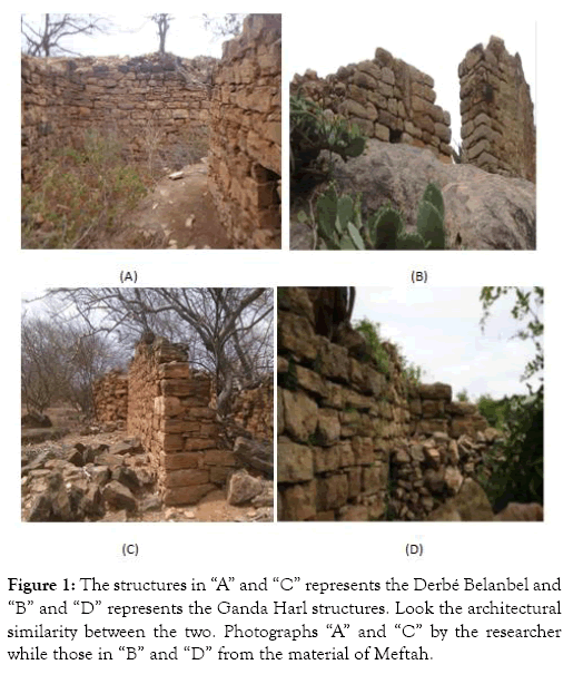
Figure 1: The structures in “A” and “C” represents the Derbé Belanbel and “B” and “D” represents the Ganda Harl structures. Look the architectural similarity between the two. Photographs “A” and “C” by the researcher while those in “B” and “D” from the material of Meftah.
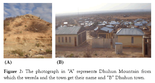
Figure 2: The photograph in “A” represents Dhuhun Mountain from which the wereda and the town get their name and “B” Dhuhun town.
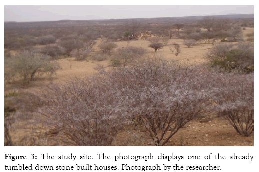
Figure 3: The study site. The photograph displays one of the already tumbled down stone built houses. Photograph by the researcher.
As stated at the beginning, this historical site is located about 200 kilometers away from the town of Degahbur. It consists, among others, of an ambitiously planned Mosque, more than 40 ruined stone built houses together with their refuse heaps, and megaliths. The selection of the site seems a very calculated move in that it still has a quarry from which the people cut out and shaped stone for the construction of the houses as well as that of the Mosque. However, unlike many of the medieval structures found in Ethiopia, the site left no sign of defense. We have at least two reasons to argue so. The first one is that the town had flourished in an almost lowland area as compared with the uplands and mountainous areas that pretend to be natural defensive formations erected by providence that squarely surround the site. Secondly, there is no protecting structure or walls like the Jegol Gemb of Harar and the castles of Gondar, constructed for defense purpose. Therefore, the size and number of stone built houses, one of these a lavishly constructed Mosque, and the absence of defensive precautions show the existence of prosperous and peaceful communities, an assumption confirmed by informants.
Neither scholarly studies nor widely held traditions provide precise information as to when this civilization thrived. However, the similar story in the extant literature and the oral information regarding this intriguing question is interesting in that both kind of explanations point to the medieval period. Informants maintain that these ruined houses flourished 600 years BP. When we deduct 600 years from 2017, we get 1417, a period in Ethiopian history that obviously falls in the medieval period. Similarly, scholars have speculated that ruined towns of the Derbé Belanbel types, that were located in the Zeila, Dire Dawa, Harar, and Jigjiga regions, had flourished between the 12th and 15thcenturies.The major argument that they have maintained to substantiate their position is that they had flourished in the period mentioned above because they had enjoyed a relatively peaceful period to thrive while the Christian highland kingdom and the several Islamic Sultanates and principalities were pitting against each other for supremacy. Besides, both the existing literature and informants attribute the entire marine as well as the inland ruined towns to the Harla. Nevertheless, the other controversial issue that scholars who have developed interest in the study of historical and archaeological sites in this part of Ethiopia asked is whether the Harla people are Somalis or not. While the Ethiopian Somalis unanimously confirm that, as we shall see the short genealogy after a while, the Harla were an almost extinct Somali clan, the literature show a sense of skepticism over their Somali origin. Leaving this contested issue for further investigation, let us now focus on the subject of our interest, Derbé Belanbel.
According to informants, the Harla Somalis who used to practice mixed farming established the ruined town of Derbé Belanbel. For them, it was a religious settlement where the Sheiks set out for the “Great Commission” of preaching Islam among other Somali clans. The Ethiopian Somalis in general and the residents of the area in particular relate the genealogy of Harla with the Darod clan, one of the two major clans of the Somali peoples. Darod, they recount, had a son by the name Keblala who gave birth to Kombé, the father of Harla. Now, let us give an analysis of the ruined stone built houses, the Mosque, the stone slabs and other related developments (Table 1).
| S/N | Name | Age | Place of Interview | Date of Interview (E.C) | Occupation/Social Standing |
|---|---|---|---|---|---|
| 1 | Ahmed Abdulahi | 55 | Dhuhun Town | 3/12/2009 | Driver |
| 2 | Abdulahi Hassan | 65 | Dhuhun Town | 4/12/2009 | Member of the regional polis force in the rank of Shambel |
| 3 | Badal Abdulahi | 67 | Jigjiga | 20/11/2009 | Director of Somali language and poet in the CTBES |
| 4 | Dugsiye Ahmed | 34 | Jigjiga | 19/11/2009 | My translator who works in Cultural Case Studies of the ESCTB |
| 5 | Hassan Ismael | 70 | Dhuhun Town | 4/12/2009 | Sheik and elder who has good knowledge about the Harla civilization |
| 6 | Haybe Nur | 82 | Dhuhun Town | 4/12/2009 | An elder and resident of the town |
| 7 | Ise Osman | 83 | Dhuhun Town | 4/12/2009 | Sheik and elder who has good knowledge about the Harla civilization |
| 8 | Mahammad Ahmad | 45 | Dhuhun Town | 4/12/2009 | Qebele official in the town |
| 9 | Mahammad Muhummed | 35 | Dhuhun Town | 4/12/2009 | Resident of Derbé Belanbel qebele who showed us to the very site |
| 10 | Mahamed Mosse | 26 | Dhuhun Town | 4/12/2009 | A militia who told us the precarious situation of the site |
List of Informants
Table 1: Details of the informants
The ruined stone built houses
Before we set out for the site, people told us that there were above 50 stone built ruined houses. On having visited the site, however, we realized that they told us a somehow inflated figure, as we were able to count only around 40 including the Mosque. In a mixed feeling of excitement and regret, we lost no time to observe that all the stone built houses left no trace of roofing and a significant portion of the structures had already collapsed presumably many years before. All the houses built in the shape of a rectangle are of different sizes. The largest of this, situated at the hillock of the site, has six classes. As compared with the other houses, it displays walls in all its sides that measure 2 meters above the ground. The structure measures10 meters in length and 7 meters in width. Its strategic location and relatively large size make us to deduce that the house might have been the residence of those in charge of leadership role, a palace in modern times. Immediately in its southern side of the wall, a square displays sitting stones laid down east and west in the shape of a semi-circle. Outside the square, we observed some fallen stone slabs that measure 2 meters. The still standing external and internal walls of the house also suggest that the builders took utmost attention obviously to satisfy and please the authorities. Few meters, west and east, away from this structure are two ruined houses, may be the houses of those who had helped the leader in advisory and administrative as well as judicial roles. The presence of a stone slab engraved in the shape of a lion strengthens our speculation as to the ownership of the house because lions are often associated with leadership, power, audacity, reverence, and royalty.
The plans of the houses in this site indicate that there was the difficulty of obtaining local supplies of roofing timber, a difficulty that the exotic eucalyptus tree has solved now. The smallest of the houses has a single room measuring 3 meters width and 5 meters length. Unfortunately, the greater parts of these houses had already collapsed to the extent that some of them became heap of fallen stones. Some others are covered with trees, bushes, shrubs, and anthills (Figure 4).
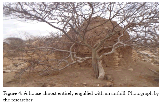
Figure 4: A house almost entirely engulfed with an anthill. Photograph by the researcher.
The walls built of roughly dressed stones laid in alternate courses of large and small material seem to be bounded with mud instead of lime mortar. The partition walls inside the house stood detached from the outer wall. It is difficult to measure the original height of the rooms, but in some cases, they would appear to have been about 3 meters high. There were no windows in the modern sense of the word, and lighting and ventilation, other than from the door, must have come in through small rectangular holes, about 30 cm in height, set in the walls about 2.4 meters height from the ground. The floor was of flattened earth in all the houses investigated. The roof, though totally collapsed at the time of investigation, was probably formed of brushwood, laid over a framework of roof beams of local wood, made probably from any of the species of acacia trees which even today is the dominant tree there, and covered with earth; a tradition of roof making among the Ethiopian Somalis that has continued to our days. We have observed square or rectangularheaded niches or inner windows in many of the still surviving walls and must have served as cupboards where they placed different materials like knives, swords, and Holy Scriptures inside. There were no signs of doors fixed and it is probable that a cloth or skin, attached to fairly long rectangular stone slab placed horizontally, serving as a curtain, covered the opening.
Before we move to the discussion of other aspects of the site, let us devote few lines for a structure located North West of the Mosque. We render special attention for this house because it displays, as compared with the many stone built houses, a somehow different architectural style. For a better understanding of the things about which we shall discuss, let us first display a photograph of the house here under (Figure 5).
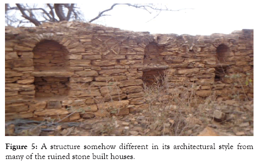
Figure 5: A structure somehow different in its architectural style from many of the ruined stone built houses.
The house is located southwest of the Mosque. As we can see from the above photograph, unlike other houses in this site, the greater part of the structure survived the perils of nature as well as human interference. One reason for this is perhaps the greater care that the builders had given at the time of construction. Another unique feature of this structure is that it has many large seized cupboards portioned in the middle with stone slabs laid down horizontally. In addition to the seize, the cupboards forms an arch at the top, a shape which we see only in the Mosque. Moreover, the part of the inside walls between the two cupboards as shown above are decorated with engravings in the shape of a diamond and floral as well as perhaps rather oddly a star instead of the crescent which add a measure of elegance to the structure. Its proximity to the Mosque and the similarity in their architectural style all suggest that the structure must have been the house of religious leaders or the Sheiks.
The mosque
Of all the structures found at Derbé Belanbel, the Mosque was the most elaborate and energetically constructed building. This appears the only occasion in all the efforts exerted there where the masons if not the engineers had applied lime mortar to bind the stones. The ‘Mihrab’ of the Mosque had collapsed and immediately outside the southeastern corner of the wall of the Mosque proper was storage well, the depth of which we cannot measure because big stones filled its pit. There is no doubt in our part that believers had used the water from this well for ablutions before the prayers witnessing that the building was certainly a Mosque. Built in the shape of perfect circle, the water well, as shown below, displays the high level of knowledge and skill that the builders possessed in geometry (Figure 6).
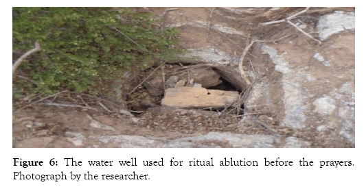
Figure 6: The water well used for ritual ablution before the prayers. Photograph by the researcher.
The Mosque roughly measures15 meters length and 12 meters width. The roof as well as the external walls, with the exception of the eastern side of the building, had already collapsed. The internal part contains about 18 pillars each connected with elegantly built arches. Unfortunately, except the four arches, two of these located in the south and the other two in the east, and nine pillars, the rest had totally ruined.
The Mosque at Derbé Belanbel depicts Gothic architecture. The pointed arch as one defining attribute of Gothic architecture is reflected in the several arches built in the inner part of the Mosque, an architectural style employed in medieval palace and Christian as well as Islamic sacred constructions in many parts of Ethiopia. It is common knowledge that the Jegol Gemb and the castles of Fasiledes in the historic cities of Harar and Gondar respectively display such architectural style as the one in the Mosque at Derbé Belanbel. If we take what informants have said for granted, this settlement predated both the Jegol Gemb and the castles of Fasiledes (Figure 7).
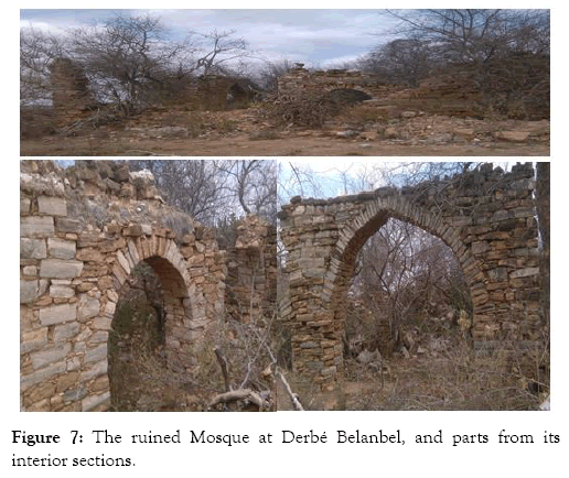
Figure 7: The ruined Mosque at Derbé Belanbel, and parts from its interior sections.
Another fascinating test we observed in this structure is that, unlike what is common to the several stone built houses, the builders had used very beautiful sedimentary rectangular stone slabs that give the Mosque a graceful and attractive look. Almost the entire body of the Mosque was built with this stone, an indication of the high regard that the people had displayed for their religion. However, unless the concerned bodies would take immediate action to protect them, at present, the entire structure is in a perilous state and undoubtedly will totally collapse in the near future (Figure 8).
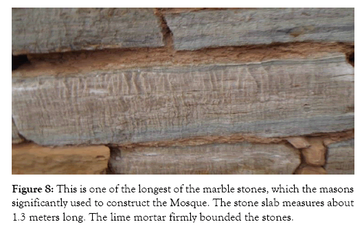
Figure 8: This is one of the longest of the marble stones, which the masons significantly used to construct the Mosque. The stone slab measures about 1.3 meters long. The lime mortar firmly bounded the stones.
Between the water well and the southern right corner of the building, we find a rectangular structure that is attached from the main building but oddly projected to the east that roughly measures 5 meters length and 2 meters width. Few meters east of the Mosque, there is an open space perhaps a market place because the flattened ground displays pieces of cobblestones scattered over the surface of the earth, may be a coping mechanism of the rainy season. The fact that the structure about which we were talking above is projected towards the open space means that there might have been a shop attached to the Mosque, a tradition that has continued down to this day.
The steles
Like the entire settlement, the steles at this site are of uncertain age. As far as we have tried to investigate, both the fallen and the sill standing stone slabs numbered above 40. They are not located in one place. Situated around the southern stone built houses especially near the big one built in the hillock, they form a bunch from some six in one place, the biggest number in one cluster, to two in another. Geometrically speaking, many of the structures are flat and are rectangular and conical in shape. There is a striking geometric similarity between these at Derbé Belanbel and Ţiya megaliths located in the Guraghe Zone of Southern Ethiopia (Figure 9).
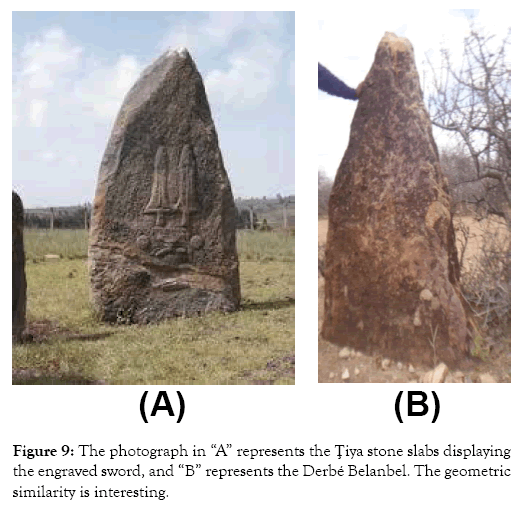
Figure 9: The photograph in “A” represents the Ţiya stone slabs displaying the engraved sword, and “B” represents the Derbé Belanbel. The geometric similarity is interesting.
The major difference between them is in the kind of engravings, paintings, decorations, and symbols they feature. For example, unlike the ones in Ţiya, none of the structures in Derbé Belanbel features the symbol of a sword. Again, we do not find paintings in Ţiya that feature fauna while we find at Derbé Belanbel, at least in two occasions. One of these is a fascinating painting that displays a lion chasing after different wild animals and the other an impressive engraving that clearly depict a lion and its mane. The paintings and the engravings are live witnesses of the skills that the people had possessed in fine arts. They tried to represent the physical world of their time with the help of the artistic skill they had possessed. Such productions of art is a pointer to the kind of wild animals found in the area at the time and a very interesting portrayal of the prey and predator game among the animal world. There are also other stone slabs painted with enigmatic pictures, as it is difficult to decipher the meanings from the already faded away paintings (Figure 10).
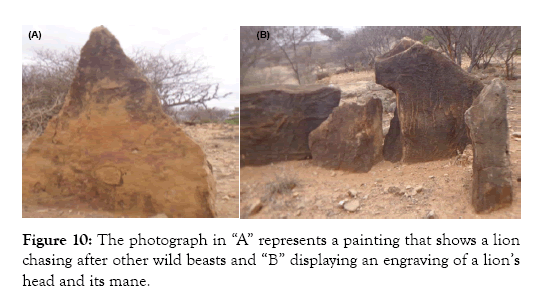
Figure 10: The photograph in “A” represents a painting that shows a lion chasing after other wild beasts and “B” displaying an engraving of a lion’s head and its mane.
As noted earlier, the typical tree of the area is acacia. In one of the fallen stone slabs, we see an engraving that features an interesting floral pattern, which resembles acacia trees found in the study site. Another difference is that the surface of the stones at Derbé Belanbel is harder than the ones at Ţiya. This is perhaps one reason for the absence of many engravings here at Derbé Belanbel and presumably the main reason to resort to painting. Informants told us that the artists had extracted the ink used for painting from Qedon (Qadhoon in Somali tongue) tree, which is still available in the area and even at the site, which produces red color (Figures 11-13).
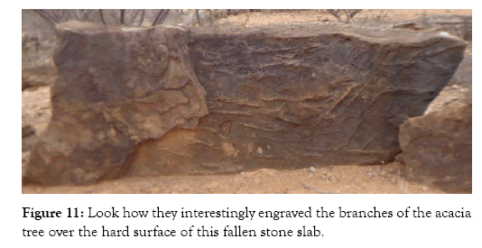
Figure 11: Look how they interestingly engraved the branches of the acacia tree over the hard surface of this fallen stone slab.
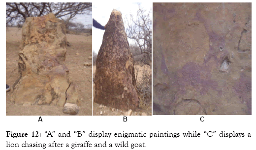
Figure 12: “A” and “B” display enigmatic paintings while “C” displays a lion chasing after a giraffe and a wild goat.
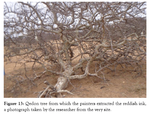
Figure 13: Qedon tree from which the painters extracted the reddish ink, a photograph taken by the researcher from the very site.
Other objects found at the site
As is often the case with such settlement sites, we have recovered different objects scattered on the surface of refuse-heaps and amongst the ruined houses. We have collected four kinds of objects. These are fragments of pottery, glasses, beads and bones. It is impossible to date the fragments. Therefore, we have to wait for further historical and archaeological studies that would come up hopefully with new findings with the help of radio carbon dating method.
Of all the material objects recovered at the site, coarse hand-made pottery fragments figures prominently followed by beads, bones and glasses. The fragments are mainly black and reddish in color (Figure 14).
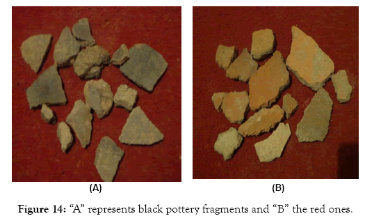
Figure 14: “A” represents black pottery fragments and “B” the red ones.
Very few of these feature different incised floral decorations and one of these display very interesting painting both on the inner and outer part of the fragment. This was more appropriately a fragment of a drinking vessel. Some of the fragments give hints as to what kind of objects they originally were. A fragment of handle, for example, suggests that the object was undoubtedly a pot. Depending on the size of the fragment, this might have been a coffee pot or a pot used for containing water, butter or paprika. Those that feature floral decorations, some featuring the feathers of birds, might have been used to keep invaluable luxuries or for burning incense. Pottery products might have also used for storing grain, boiling water, roasting grain, cooking food and baking injera or bread (Figure 15).
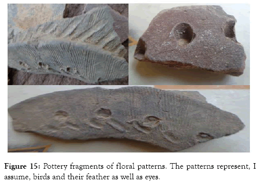
Figure 15: Pottery fragments of floral patterns. The patterns represent, I assume, birds and their feather as well as eyes.
Another remarkable pottery product is a small round ornament made from clay with a hole at the middle, which, according to informants, was used for ornamentation put around the necks of women and children (Figure 16).
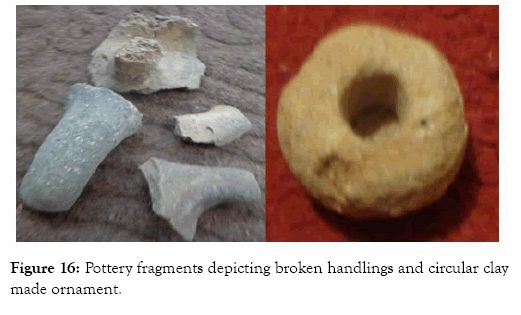
Figure 16: Pottery fragments depicting broken handlings and circular clay made ornament.
The site also produced a number of fragments of thin green and black glass vessels. We have also recovered beads, which, according to informants, were imported from Arabia and were used for ornamentation, which women and children put around their neck. The bones found on the refuse heaps show that domestic animals like camel, sheep, or goats formed important items of diet (Figure 17).
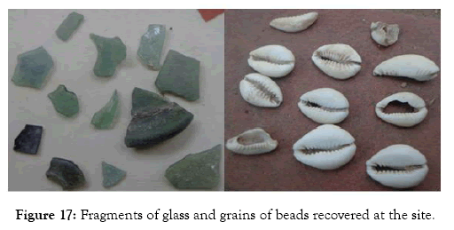
Figure 17: Fragments of glass and grains of beads recovered at the site.
No one speaks with certainty as to why this civilization collapsed. We have three reasons for the destruction of the Harla culture in general. Informants from that very area told us that these people had lived on mixed farming and trade and were very rich. The Harla, informants add, once got good harvest of teff, something that we need to verify with further archaeological findings, and sorghum, baked it, spread on the ground and sat on the Injera. They even had mounted on their horses and had walked on it. Because of their inordinate pride, God punished them with drought and famine, which in turn caused them to vacate the area and disappear. The second assumption relates their destruction with the expansion of other Somali clans who subsequently swallowed them. Finally, the 16th century Oromo population movement and expansion was regarded as the cause for the destruction of Harla civilization who in the process had assimilated them. However, the last argument seems erroneous because the site about which we are talking about is located deep in Somali territory, the Ogaden, an area that may not be easily affected by the Oromo population movement and expansion.
Though Dhuhun wereda hosts the historical site we have discussed above which in some respects resembles the country’s UNESCO world heritage sites like Tiya megalith, the ancient city of Harar, and the castles of Gondar, we have observed the following challenges that heavily hamper the efforts of researchers to study the site. The major challenges include lack of transportation, electricity, and accommodation such as hotels and lodges. The nearest asphalted road that passes through Degahbur to Gode is far from the wereda by about 200 kilometers. The only transport service between Degahbur and Segag wereda is an Isuzu bus that shuttle on daily basis. Segag town is far from Degahbur by about 125 kilometers. However, because of the absence of an all-weather road, it takes the Isuzu bus 10 hours to arrive. The journey is precarious at least for two reasons. One is that the bus transports both human beings and merchandise often beyond its capacity. Secondly, the road is not paved. Therefore, the drivers, who have good knowledge of the topography of the area, have to choose the good grounds to move forward often at the snail’s speed.
The worst is yet to come. On having arrived Segag town, unless it happens in a very rare and lucky occasion, one has to stay there even for weeks depending on the availability of transportation. There is no public transportation from Segag to Dhuhun wereda. So, one has to win the willingness of the local administrators to use their Land Cruiser which sometimes goes to the weredas whenever there are meetings. Besides, cooperation and willingness significantly wan as one move from Jigjiga to the remote weredas.
The other major problem is the attention that stakeholders give for the conservation of the historical site. As we have observed, the site received little or no protection from both the local level administration and the residents of the wereda. One manifestation of this is that, informants told us, people have continually used the blocks of stones from the ruined heaps to construct their houses with no one from the local level administration prohibiting them doing so. Therefore, natural factors like whirlwind and lightening, heavy showers of rain and bushes, shrubs and trees grown over the houses coupled with anthropogenic causes would undoubtedly hasten the total destruction of the historical site. This is a huge loss for the history and tourism industry of the region. Generally, poor conservation of the potential resources and absence of promoting them to the public are the main challenges.
Nevertheless, despite the above challenges, we are not very desperate in this direction. There are opportunities, which we need to use to do research, preserve and promote the historical site in question. One such opportunity is the presence of friendly communication between regional, zonal and wereda level administrators and workers. Had it not been the willingness and cooperation that we received from all levels of administrators, the success that we have so far would have been a mere dream. Equally important is the warm welcome and cooperation that the people of the wereda displays whenever there is such a demand. The relative proximity of the wereda to the asphalted road that passes through Degahbur to Gode and the relative security of the area also render an easy and safe access to the site.
As much as we have tried to investigate in this very study and from the existing literature, the Ethiopian Somali Regional State has a huge potential of historical and cultural sites. One of these is Derbé Belanbel that, according to a widely held tradition, came into being 600 years BP. Both oral data and scholarly contributions ascribe the several stone built houses, Mosques, and necropolis to the Harla. Harla, according to informants, was forth from Darod. Therefore, the cultural and historical remains at Derbé Belanbel are probably the achievements of these people. The fact that this site is located deep in Somali territory removes our suspicion as to whether this cultural achievement is truly a Somali or not. Further archaeological studies will sufficiently answer the confusions, if any, as to the agency of the Derbé Belanbel civilization. Therefore, if what we have suggested above is to be believed, the assumption that all the Somalis have been pastoralists who have no traditions of stone building technology is wrong. Derbé Belanbel is but one testimony.
When we look into its historical significance, both the period of its establishment and the different cultural remains found there gives it the standard that some of the country’s historical sites has attained. Chronologically, it predates both the Jegol Gemb and the castles of Gondar. The variety of still standing remains outshine other cultural sites because they display fine architecture, sculpture, and art, a collection of cultural achievement that we hardly find in other historical sites in one place. The architectural skill reflected in the construction of the Mosque, and the artistic skill that the people had demonstrated on the steles give the site a special place in the country’s historical and cultural studies.
The study, therefore, shows that the cultural site is of huge contribution for the reconstruction of the history of the Ethiopian Somalis of medieval Ethiopia. However, to make use of its full potential, the region has to consider the following recommendations very seriously.
• To prevent further destruction, the area must be reserved. This could be done by the immediate wereda in collaboration with the local community where the site is located.
• All the trees, bushes, and shrubs that grow out of the walls have to be carefully removed because they would exacerbate the collapse of the still precariously standing structures.
• The local level administrators with the collaboration of the Zonal and Regional authorities should create awareness among the residents of the weredas about the significance of the site. By doing so, it is possible to involve the community in the protection of the site from further destruction.
• The wereda must give direction to the effect that people would no longer transport the ruined stones from the site to build their houses.
• The site must be temporarily fenced to prevent people, cattle, and other domestic animals from entering into the site.
• With the collaboration of the Federal and Regional Culture and Tourism Bureaus, an all-weather drive way has to be constructed from Degahbur to Dhuhun wereda so that things would be easy for researchers and visitors in the future.
• The regional press and media have to do works of promotion.
• If it fulfills the preconditions necessary to that end, it has to be registered in UNISCO as world heritage site.
Citation: Bogale W (2020) A History of Derbé Belanbel Historical and Cultural Site. J Tourism Hospit 8:422. doi: 10.35248/2167-0269.19.8.422
Received: 17-Oct-2019 Accepted: 26-Dec-2019 Published: 03-Jan-2020
Copyright: © 2020 Bogale W. This is an open-access article distributed under the terms of the Creative Commons Attribution License, which permits unrestricted use, distribution, and reproduction in any medium, provided the original author and source are credited.