Journal of Pollution Effects & Control
Open Access
ISSN: 2375-4397
ISSN: 2375-4397
Research Article - (2015) Volume 3, Issue 3
In Nigeria, over a score of urban water agencies depend on rivers and other surface water bodies for their raw water intakes. But many of these rivers are currently under unregulated threat from inadequate catchment management. The persistent failure to regulate and take advantage of the work that healthy watersheds perform naturally is currently overwhelming the ability of public water agencies to mitigate catchment sourced contaminants at a fraction of the cost of conventional treatment and guaranty safe drinking water to water consumers. This paper reviews a case study drawn from the Anambra-Imo River basin (one of the twelve River Basins in Nigeria) where intensive agriculture and poor land management activities, especially on catchments of key rivers serving water utilities, has increased pollution threats by non-point pollution; both organic and chemical. Human induced catchment activities, especially agriculture and deforestation has left sloping lands susceptible to rapid flood runoff and massive mudslides. However, an initiative by a Non-Governmental Organization (NGO) developed a collaborative liaison for land management leveraged by catchment sensitive farming, knowledge sharing and awareness creation amongst farmers and landowners etc. aimed at restoring quality on the fragile water bodies of the expansive river basin, particularly the Otammiri River, thus bolstering its resilience to diffuse pollution from agricultural nitrates and phosphates. The emerging result from the pilot was reduced risk of contamination breaching the drinking water system hence supporting the provision of the human population with safe drinking water, which is one of the most important issues in public health.
Keywords: Nigeria; Owerri; River; Agriculture; Pollution; Catchment; Runoff; Farming; Farmer; Water utility
Otammiri River is the primary raw water source for the Imo State Water Corporation (ISWC), a public water supply agency. The Corporation supplies drinking water to the residents of Owerri, the capital city of the State. The Otammiri River is one of the many rivers in the larger Anambra-Imo River basin. However, upstream agriculture and deforestation activities have continued to diminish the ability of the river to continue to play this role in the future. The combination of intensive agriculture and deforestation, in addition to sand mining and residential activities continued to pose enormous threat to the over 2 million Owerri residents who depend on ISWC for their long term water needs.
Agriculture poses the greatest threat based on the enormous amount of fertilizer (organic and inorganic) used on commercial and private farms. The result is widespread Nitrates, a by-product of nitrogen-based farm fertilizer, animal manure, wastewater and leaky septic tanks. On top of these are wasteful and inefficient agricultural practices, including very low knowledge of fertilization application. For example, it was observed that many vegetable farmers can apply as much fertilizer as they want, within feet of the river.
Further observations and surveys in the course of this study showed that the leading source of nitrate pollution in many parts of the larger Anambra-Imo River basin-nitrogen fertilizer - is not regulated. For example, agriculture nitrate and phosphate has in combination to the region’s high intensity sunshine and warmth, triggered blue-green algae bloom in the utility’s reservoir [1-3]. The result has been incidents of toxic compounds released by the algae such as cyanotoxins gradually inundating the city’s water-treatment plants. Already taste and smell has been reported by consumers. Such toxins especially Microcystins and nodularins are feared and can be dangerous for humans and animals [4]. As at the time of the pilot, it was already posing technical challenge for ISWC managers, for example, many purification methods used by the ISWC was incapable of removing the nitrate contaminants from the water. The result is that the quality of water supplied by ISWC became a public health challenge. An incident of poorly managed catchment has also been reported by [5] and the resultant expensive cost of water treatment which it posed.
The consequence is that the alternative reliance of city residents on waters provided by vendors sourcing from elsewhere, has come at the high cost of between US$0.92 -US$4.80 per 100 gallons thus taking clean drinking water above the reach of the average poor. Beyond drinking water concerns, eutrophication has also produced so much vegetation that recreational use of the Otammiri River and other neighbouring surface water bodies such as the Oguta Lake; a wetland of international importance is now constrained. Reference [6] notes that toxic blue-green algae in water used as drinking water or for recreational purposes poses a hazard to humans but has long been neglected or at most been treated on a local level. Scums of blue green algae or cyanobacteria accumulating along the shores of ponds and lakes also present hazards to wild and domestic animals [6]. Reference [4] notes that prevention of bloom formation is the most efficient method for avoiding cyanobacterial toxin contamination of drinking water because the presence of cyanobacterial toxins in drinking water supplies poses a serious problem to water treatment facilities, since not all technical procedures are able to effectively remove these toxins to below acceptable levels.
Project location and background
The Project location lies within the tropical rain forest belt of Nigeria. It is found within the Owerri area (Figure 1) in Imo State, Nigeria and is bounded by latitudes 5°26’ and 5°45’ and longitudes 658’ and 7°10’ E. It covers an area of about 740 km. The Anambra-Imo River Basin is the largest river basin (Figure 2) in southern Nigeria and encompasses five states of Nigeria - Imo, Anambra, Enugu, Abia and Ebonyi states; with a whopping population of well over 15 million people. Another strategic importance of this basin is that it hosts the Oguta Lake, a wetland of international importance (Ramsar listed site) that measures 572 ha and can be located on coordinates 05°42’ N 006°47’ E.
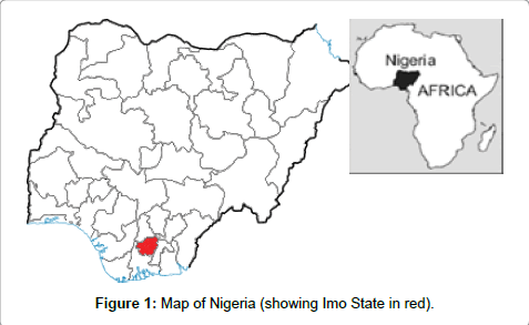
Figure 1: Map of Nigeria (showing Imo State in red).
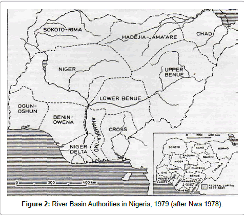
Figure 2: River Basin Authorities in Nigeria, 1979 (after Nwa 1978).
All rivers in this region empty into the Imo River, including the Otammiri River. Agriculture and deforested lands account for more than half of the land use in the entire basin (Table 1). In this basin, agricultural activities, especially those on farmlands in both rural and urban area are located on critical watersheds and therefore use rivers as final discharge points for their non-point pollutions; both organic and chemical. Hundreds of indigenous plants and animal species such as large populations of antelopes, Buffon’s kob (kobus kob rob), Bohor reedbuck (Redunca redunca) and the waterbuck (kobus ellipsiprymnus defassa) etc., are found in the basin, though eutrophication has joined the threat list of game hunting and bushfires to diminish their diversity.
| Land Use Characteristics | Northern | Southern | Central |
| Farmland/fallow areas Industrial, educational area Residential areas Nature conservation areas Erosion sites Others Relative population distribution |
65% 1% 25% 8% 0.1% 0.9% Moderate |
55% 5% 35% 2% 0.2% 3.8% Moderate |
5% 10% 80% 1% 0.3% 4.7% Dense |
Table 1: Land Use characteristics of the Watershed.
Water pollution is getting critical in the study area. It is noted that upstream agricultural activities exacerbates non-point pollution through nitrates, while deforestation made sloping lands susceptible to rapid flood runoff and massive mudslides, in addition to increasing the economic and human toll of floods and other economic and social disasters, a toll almost certain to increase as climate change challenges the water cycle.
Another key problem posed by deforestation is the increased concentrations of soil particles washed into the stream by land disturbance, which sink to the bottom of the river and increase the bed loads while, depending on the stream velocity, smaller particles remain in suspension. Suspended matter in the Otammiri River obstructs the penetration of light and limits the photosynthetic zone to less than 1 m depth. Suspended sediments in the river in addition to nutrient loadings from nitrates and phosphates have become a serious concern for the water supply authorities in Owerri because they exert huge water treatment costs.
Studies by [7] shows that the Otamiri River has a maximum average flow of 10.7 m3/s in the rainy season (September-October) and a minimum average flow of about 3.4m3/s in the dry season (November- February). The total annual discharge of the Otamiri is about 1.7 × 10⁸ m3/s, and 22 percent of this (3.74 x 10⁷m3) comes from direct runoff from rainwater and constitute the safe yield of the river. However, recent preliminary studies by the author shows that these are no longer the case as the average flow has shrunk by as much as 55% in both the raining and dry seasons.
Eutrophication by nutrients (especially nitrates and phosphates) has given rise to accelerated rise of algae and higher forms of plant life which has consequently led to the undesirable disturbance to the balance of organisms present in and dependent on the water and its quality. The resulting disturbed aquatic ecosystem is rapidly becoming an unsuitable habitat for other species such as fish and invertebrates. The threat to biodiversity of both the aquatic habitat and of other species in the food chain in the Otammiri ecosystem is not fully studied but it is believed that it poses very low oxygen levels for some species to tolerate, especially the local fish species. Threatened biodiversity includes those of fish, Cichlid and Tilapia etc. Small population of roan antelope (Hippotragus equinus) and the red-fronted gazelle (Gazella rufifrons) also exist in this watershed.
The blue-green algae bloom in ISWC reservoirs has been linked to the high intensity sunshine’s and warmth of the watershed. [6] Posits that algal growth is influenced mainly by water composition, temperature and light intensity. Lowland water storage reservoirs, where the abstracted river water carries treated sewage effluent and agricultural run-off, contain relatively high levels of nitrogen and phosphorus compounds that promote the growth of algae. In many nutrient rich or so-called eutrophic waters, the growth potential of algae is determined by the dissolved phosphate concentration in the water [6]. Notes that a characteristic of algal blooms, which contributes to their nuisance value, is the tendency to form a surface scum. Cyanobacteria have a buoyancy control mechanism that maintains their vertical position in relation to the wind-induced circulation in the water column. Under calm conditions, when natural circulation within the water ceases, algae float and produce a scum that accumulates in the margins. This presents a possible health risk for recreational activities that involve water contact and for animals that drink from the margins of reservoirs. Another significant adverse effect of algal blooms is their propensity to cause de-oxygenation. During daytime, algae use carbon dioxide from the bicarbonate ions in the water and respire oxygen into the water. At night this process is reversed and the carbon dioxide respiration can cause localised oxygen depletion and consequent fish mortalities.
Some species of cyanobacteria produce toxins within their cell structure. These toxins can be released when the algae die and decay. Toxin release can also occur during the growth phase of young algae. The implications of toxic algal blooms are significant and likely to become more so if global warming results in reduced flow in rivers with correspondingly less dilution for effluents and agricultural run-off.
In its 2003 Background Document for the Development of WHO Guidelines for Drinking-Water Quality, WHO noted that recreational use of water contaminated with toxic algae had been linked to incidents of human illness in many countries. Symptoms ranged from sickness with diarrhoea to muscle and joint pains and irritation of the skin, eyes and throat. WHO also considered reports of illnesses associated with the consumption of contaminated drinking water reported in the USA, Australia, South Africa and China. In China incidence of liver cancer was related to consumption of contaminated water from ponds and ditches [6].
Project design and ownership
To meet the water challenges of the future in Owerri, there is the need to figure out how to deal with nitrates and one of the options is the collaborative project described in the paper.
The lead NGO responsible for the initiative was the Rural Africa Water Development Project (RAWDP). RAWDP is a community development program funded through open challenge funds. RAWDP’s goal was to engage communities and its people in the protection of their water sources and the promotion of broad-based pro-poor growth in water and sanitation access delivery. To pursue this goal, RAWDP drives systemic change by mapping and delineating water resources pollution points, and widening the distribution and accessibility of appropriate clean water and sanitation infrastructure through active partnership with water resource management institutions, communities and entrepreneurs. Such partnerships aim to support innovative ideas, investment and regulatory reform that will bolster resource resilience, improve business performance, stimulate economic growth and ultimately provide benefits for the poor.
Other NGOs includes the Pan African Vision of the Environment (PAVE) and the Organised Centre for Women Empowerment (OCEAN) in addition to government institutions such as the Anambra- Imo River Basin Authority, the Imo State Water Corporation and other groups.
The project used a six step process methodology that comprised of the following, with (Table 2) illustrating the steps, activities and timelines.
| STEPS | Activities | Timeline |
| One | Stakeholders’ mapping and engagement | May-December 2013 |
| Two | Identification of critical acres and designation of Nitrate Vulnerable Zones | January-March 2014 |
| Three | Formulation of intervention and cost | April-July 2014 |
| Four | Implementation of selected interventions | Aug 2014-December 2014 |
| Five | Monitoring and Evaluation activities | January 2015-March 2015 |
| Six | Learning lessons | April 2015-Continuing |
Table 2: Schedule of activities and timelines.
Stakeholders’ mapping and engagement
The project used a 3 step approach to identify and bring key stakeholders on board. The first step was stakeholder mapping, which enabled the project to identify existing farmers, land owners and occupiers/tenants etc. The second step involved building awareness of these stakeholders on the need to address at source the poor land management challenges that impact water quality in the watershed [8]. The third step involved building-in support and systems for change in on-the–farm practices and other associated issues such as the shortlisting and cost analysis of possible interventions.
Identification of critical acres and designation of nitrate and phosphate vulnerable zones within the catchment
The identification of the sources of nitrogen was the first step towards remediation of nutrient pollution in aquatic ecosystem. Water samples were collected during both the wet and dry seasons from different parts of the Otamiri River and the Oguta Lake. This was followed by their analysis with focus on the seasonal and spatial variations of nitrate concentration and sources. This enabled the project to determine critical acres and designation of Nitrate and Phosphate Vulnerable Zones within the catchment. To effectively do that, the project employed the Oxygen Isotopic composition as an additional marker of nitrate sources due to the large variation of δ18O ranges among different sources [9,10]. The key objective underpinning the use of the dual isotopic approach in tracing the nitrate dynamics was to investigate the spatial and seasonal variations of nitrate concentrations in the principal waters of the catchment. This approach is unlike the both the use of the Nitrogen Isotope and the traditional analysis of nitrate sources. While the later determines nitrate concentration in freshwater systems and potential nitrate sources of fresh water supplies. However, it suffers from the possibility of multiple nitrate sources and some biogeochemical processes. On the other hand, the former, specifically, δ18O informs the sources of nitrate due to the distinct isotopic characteristics of main nitrate sources such as septic systems, animal waste, commercial fertilizer and decaying organic matter [11,12]. However, its efficacy is constrained by the difficulty associated with differentiating these sources because of some significant overlaps in δ15N-NO3- ranges. Moreover, fractionation process may constrain the accuracy of NO3- source identification. For example, kinetic isotope effects during microbial de-nitrification can cause the enrichment of the heavy isotopes in the remaining NO3- [13]. The dual isotopic approach used in the project as described by the paper has successfully been used to investigate the nitrate sources of Mississippi Rivers and the Illinois River in the US [9,10] as well as the Yangtze [14] and the Yili Rivers [15], both in China, and the Han River in Korea [16]. Those studies reported high levels of sensitivity and reliability of using dual isotopic technique for tracking nitrate sources.
Formulation of intervention and cost
Considering the huge contribution of agriculture in the overall pollution of water resources, there was the great urge to curb its continued impact. But to do this effectively, the project needed to be sure of its shortlist. It therefore opted for interventions that are solution – effective, cost – efficient and ecologically green. Participatory approaches were adopted in the promotion of best practices in land use and farm infrastructure design and development. These were shortlisted in tandem with potency in overall soil, livestock, pesticide, fertilizer and organic manure management to control diffuse water pollution from agriculture in the catchment. Apart for the technical infrastructures that were paid for; all of the advisory services to the farmers was free of charge and were delivered through workshops, demonstration events and farm visits.
Implementation of selected interventions
Some of the interventions included the establishment and maintenance of artificial wetlands and use of riparian buffer strips. Others were in-field grass buffer strips, use of drills across the slopes, reduction of dietary Nitrate and Phosphate intakes by livestock, phase feeding of livestock, use of fertilizer recommendation system, non application of fertilizer on high risk areas as well as the use of concrete surfaces in storing solid manure and simultaneously collecting the resulting effluent as well as supporting large farms to install and use Biogas plants etc. The project also provided at least 10,000 local farmers and residents within the watershed with adequate skills and awareness relevant in pollution prevention especially those emanating from local farms in this intensively farmed watershed.
Monitoring and evaluation activities
The Monitoring and Evaluation process chiefly used data collected on water quality indicators at their current (benchmark) levels (both ecological and social), and tracked changes in these indicators over time. The project had followed a systematic process of monitoring the achievements of the project operations, collecting and analysing farm activities to track progress toward planned results; using output information and evaluation to influence decision– making and resource allocation; and communicating results achieved, or not attained, to advance learning. In a nutshell this translates to learning from the on-the-farm real world experiences to improve effectiveness, efficiency and knowledge critical in achieving results. Results were often derived from rigorous investigation and analysis of farm activities; applying multi-disciplinary expertise and relying upon well-informed participatory insights from target farmers and land owners etc., The hierarchy of results captured within this iterative cycle occurred at the Activity Level, Project Level, Intermediate Level and the highest Level Strategic Level. In other words these are also categorized as Input, Output, Outcome and Impact Results. For example, the artificial wetlands built in the catchment had fences and channels that were sufficient to capture run-off and sediment from a field or group of fields that regularly discharge run-off water and sediment. The result at this level is that the wetlands are used for the “treatment” of wastewater generated from hard-standing areas and to intercept run-off water from a field or group of fields. These were useful in trapping sediment and through the retention of run-off, reduce Nitrate and Phosphate (soluble and particulate) and free inorganic loads in water exiting the wetland. At the utility level, effective monitoring indicates that nitrate concentration limits of 10 mgN/L in drinking water is no longer breached as was the case on the baseline in utter contravention of both the National Drinking Water Quality Standard (NDWQS) as well as those of the World Health Organisation (WHO).
Lessons learned
Effective mobilization and engagement of farmers and land owners is key: The active involvement of key stakeholders-farmers and land owners; at all stages of the project ensured that water quality deterioration was checked and mitigated. This requires adroit skills in social engagement. Excellence in managing relationship with stakeholders is essential to achieving success. In doing this, the project was able to effectively identify key stakeholder groups and designed appropriate communication strategies for each group. It created a favorable ground for the promotion of the desired change.
To maintain freshwater biodiversity, it is necessary to manage the physical processes in rivers properly: These include water quality, sediment dynamics, and, of course, flow. Flow is the main driver of biodiversity in rivers–it creates the aquatic habitats, it brings the food down from upstream, it covers the floodplain with water during high flows, and it flushes the sediments and poor water quality through the system. It has been observed that a fish which is sensitive to flow conditions, insects which lay eggs in the river, or water chemistry will give the first indication that the river is changing. Ecological components of a river can be used to indicate incipient problems, before they reach the stage of endangering people and their livelihood.
Restoring watersheds restores ‘‘Ability to Produce Clean Water’’ (APCW): The ‘‘Ability to Produce Clean Water’’ - an index used in measuring severe pressure on watersheds [17] is a desired input in water utility water safety plans. The project is in tandem with the multibarrier approach for achieving drinking water safety as argued by [18]. The framework offers source protection to keep the raw water as clean as possible in order to reduce the risk of contamination breaching the drinking water system. Forested watersheds reduce storm runoff, stabilize stream banks, shade surface water, cycle nutrients, and filter pollutants [19]. For example, private companies that operate the water concessions in Manila are investing in catchment management to preserve the quality and quantity of the water on which the city depends [20]. Also, in countries with degraded water catchments, development of water storage infrastructure needs to be accompanied by improved protection of watersheds to sustain the investment [20].
Use of novel appropriate technology to advance knowledge: Through the sharing of experiences and the creation of networks across geographic regions and disciplines in Nigeria and overseas, the project hopes to access more tools, models and motivation to continue its activities. It acknowledges that emerging technologies offer unprecedented opportunities to advance water resource knowledge and information, using some of the most promising technologies such as the Thermal infrared (TIR) imagery; Digital Temperature Sensing (DTS); advanced automated samplers with telemetry; high–resolution digital topography; and spatially explicit, process–based hydro ecological models. These new technologies could help to enormously reduce present costs for soil and water resource inventories and monitoring, and provide broad geographic and temporal coverage. Expanded application of these technologies and collaboration with partners will enable the project to improve the characterization and monitoring of water resources and better understand the processes controlling them. Such data could significantly improve the ability to forecast stream flows, predict changes in vegetation, assess threats to forest health, quantify wildfire risks, identify vulnerable and resistant landscapes, and provide early warning systems for threats to people, fish, and wildfire. It could greatly facilitate the implementation of more strategic, effective and robust watershed management practices.
By adopting the catchment sensitive farming approach to improve River water quality the paper has illustrated a concerted local effort to improve the management of the freshwater resource by forging a more effective connection among people, nature and the government. Particularly, the adoption of agricultural practices that are sensitive to the water ecosystem, the change in paradigm will empower hundreds of farmers to grow more crops without exacerbating river pollution or environmental damage. The paper recognises agriculture as the dues ex machina that triggers shared prosperity and inclusive growth. Land and water resources management in this context therefore are related first and foremost to the integrity, vitality, and resilience of ecosystem structures and processes. It is acknowledged that the key to ecosystem management is the goal of ecological sustainability–protecting and restoring critical ecological components, functions, and structures in perpetuity so that future as well as current generations will have their needs met, in this case–clean drinking water.