Journal of Geography & Natural Disasters
Open Access
ISSN: 2167-0587
ISSN: 2167-0587
Research Article - (2018) Volume 8, Issue 1
Since rice is one of the important crops not only in Iran but also in the world, it is vital to determine the paddy rice field as accurately as possible using fast and economical methods such as remote sensing and GIS. Accurate and timely rice paddy field maps with a fine spatial resolution would greatly improve our understanding of the effects of paddy rice agriculture on greenhouse gases missions, food and water security, and human health. In the past, the accuracy and efficiency for rice paddy field mapping at fine spatial resolutions were limited by the poor data availability and image-based algorithms. The unique physical features of rice paddy fields during the flooding/open-canopy period were captured with the dynamics of vegetation indices, which are then used to identify rice paddy fields. In order to prepare information about spatial distribution of rice fields, Multi-Spectral and Multi-Temporal data can be helpful because in addition to the rice, all fields could be covered by mixture of water and soil regarding the time of crop calendar. The Landsat 8 data with 11 bands has visible, near infrared, shortwave infrared as well as thermal bands; and therefore, different vegetation indices can be calculated, including Normalized Difference Vegetation Index (NDVI) and Land Surface Water Index (LSWI2105) which is sensitive to leaf water and soil moisture. In this study, special mapping algorithm that uses NDVI and LSWI2105 time series data derived from LANDSAT8 16-days 30-meter vegetation indices product of LANDSAT imagery developed to identify paddy rice fields. This algorithm works based on the sensitivity of LSWI2105 to the surface moisture and NDVI to the vegetation chlorophyll content. In this research method has been developed to define the relationship between the NDVI and LSWI2105 to detect the location of paddy rice fields in North part of Iran in 2014-15. The results, a validated with ground field works data at 56 well-distributed sample points. The overall accuracy of the method was 69.0909%.
Keywords: Paddy rice; Mapping; Landsat 8; LSWI2105; NDVI; Caspian Sea
The essential importance of remote sensing over the past decades is unavoidable. Earth observation from space through various remote sensing instruments has provided a vantage means of monitoring land surface dynamics, natural resources management, and the overall state of the environment itself [1]. The earth surface materials that are considered here are vegetation, soil and water. Basically, a material can be identified from its spectral reflectance signature if the sensing system has sufficient spectral resolution to distinguish its spectrum from those of other materials. This premise provides the basis for multispectral remote sensing. Detection and making the decision of location selection of paddy rice fields’ area is an important component of obtaining more accurate information about agricultural water use to effectively manage fresh water resources [2].
Vegetation mapping also presents valuable information for understanding the natural and man-made environments through quantifying vegetation cover from local to global scales at a given time point or over a continuous period. It is critical to obtain current states of vegetation cover in order to initiate vegetation protection and restoration programs [3].
At the global and regional scales, several early studies of ecosystems and land cover have involved mapping paddy rice fields based on agricultural census data. In the late 1980s and early 1990s, several paddy rice datasets with coarse spatial resolution were produced to analyse global climate and greenhouse gas emission [4,5]. In recent years, several studies on paddy rice planting areas were conducted by combining agricultural census data at the national scale [6,7]. Although most of the crop datasets were produced with input from multiple sources, these datasets were developed mainly by relying on statistics with coarse spatial resolution that were supplied by administrative units.
In order to estimate the rice production, self-sufficiency potential should be determined. Conventionally, calculation of rice production is usually performed after harvest by collecting information from farmers. Another way of rice production can be determined by taking a rice grain from a sample area and then converting it to total of the harvest area. Both methods of rice production estimation are conducted during rice harvesting periods. These methods frequently take a long time; therefore, it would be beneficial to gain information about rice production more quickly prior to harvest to make better judgments related to rice self-sufficiency and rice import. Therefore, knowing the shape and arrangement of rice fields is vital for management of water resources and estimation of gas emissions [8].
Rice plants have specific land cover properties. Rice land coverage changes during the rice life circle. Almost all land coverage in irrigated rice fields is dominated by water during the growth period. As the rice ages, rice vegetation coverage grows and reaches a maximum (rice age=2 months) and then gradually decreases until harvest time [9].
Satellite remote sensing has been extensively applied and has been recognised as a powerful and effective instrument in detecting land use and land cover changes [10]. Peng et al. estimated separation and harvesting of paddy rice using MODIS data. The study area extended 211800 Km2 that 18 percent of agriculture used MOD09A1 8-day composite data with spatial resolution of 500 m between 2000-2007. Separation and study of early and late rice paddies has been done individually [11].
Uchida monitored rice plant with a complex culture in West Java, Indonesia, with Landsat and MODIS data. This study aimed at the development of method of monitoring paddy rice planting applicable to areas located in the tropical humid climate region. The method was integrated with two steps of procedure. As the first step, we attempted to produce land use map which discriminated paddy field using multitemporal Landsat data. In order to remove the effect of cloud cover, a new method of land use classification was introduced. This method employed five indices, which could represent the specific condition of ground surface on soil, vegetation or water, derived from Landsat data, and discriminated land use by using maximum values of indices for multi-temporal scenes. The results showed meaningful improvement in accuracy of discrimination compared to conventional method of land use classification using spectral information of Landsat data. Paddy field extracted by this step was used as paddy mask data in the following step. The second step was to construct a method to judge the time of rice planting using MODIS data. In this study, we examined the time series of EVI (Enhance Vegetation Index) and NDWI (Normalized Difference Water Index) obtained from 16-day composite MODIS vegetation product dataset in combination with statistical information obtained from local administrative offices. They developed a scheme that could estimate the place of paddy rice planting after about two months from planting. The result showed a capability of identifying time of planting rice for extensive part of West Java using MODIS data and contributed to analyze the pattern of spatial transition of area of planting for recent years [12].
MODIS sat imagery applied to find out a relationship between rice spectral (NDVI) and rice yield. The result shows that a quadratic equation is the best relationship form between NDVI and rice age with the R 2 ranging from 0.916 to 0.973. From three growth variables evaluated in this study, total of the rice NDVI during its lifetime (ΣNDVI) showed the highest exponential relationship with the rice yield (R 2=0.9203) and it has the lowest the standard error of estimation (SE=0.076). Two other variables NDVI max and Age NDVI max presented lower R 2 and higher SE of estimation, which is 0.8919, 0.5776 and 0.089, 0.175 respectively. Therefore, estimation of rice yield can be done by using equation:
y=0.4745e 0.0504x.
Where y is the rice yield and x is calculated using this equation [13]:
ΣNDVI.
A paddy field is a flooded parcel of arable land used for growing rice and other semiaquatic crops. According to its water source, paddy field can be categorized to irrigated and rain fed paddy field. During the rice transplanting period and the early part of the rice growing season, paddy fields are a mixture of green rice plants and open water [14,15]. A new generation of advanced optical sensors, including the Moderate Resolution Imaging Spectroradiometer (MODIS) on-board the Terra and Aqua satellites, provides opportunities to develop and generate improved vegetation indices that are sensitive to vegetation moisture and soil water, such as Land Surface Water Index (LSWI) and Normalized Difference Water Index (NDWI) [16-18].
A number of studies have explored the potential of satellite images for detecting seasonal vegetation changes. Optical remote sensing is often used to identify paddy rice phenology and cropping schedule. Identifying crop phenological stages from MODIS data may enable us to estimate crop growth under various regional weather conditions. A number of researches has been attempted to detect paddy rice phonological stages in wide extent of Asian region using MODIS data, e.g. Xiao et al. [8,15], Sakamoto et al. [19,20] and Uchida. They employed a kind of indices derived from MODIS data (e.g. Enhanced Vegetation Index (EVI), Normalized Difference Vegetation Index (NDVI), LSWI, and NDWI). Each researcher applied different approaches and algorithms to identify paddy rice phenology.
Sakamoto et al. [19,20] used time-series EVI data. They smoothed EVI data by time-frequency analysis to specify the paddy rice phonological stages by detecting the maximum point, minimal point, and inflection point from the smoothed EVI time profile. By applying the method to MODIS data, they determined the planting date, heading date, harvesting date, and growing period of paddy rice. Xiao et al. [8,15] used time series of two vegetation indices (LSWI and EVI or LSWI and NDVI) derived from MODIS images to identify initial period of flooding and transplanting in paddy rice fields for the purpose of paddy rice fields mapping. Application of such methods to paddy fields with complex cropping pattern has not been much examined. Uchida [13] has performed such attempt by applying Landsat and MODIS data in West Java region by using EVI, NDVI, and NDWI indices. He focused on the determination of paddy rice planting time.
Study area
Amol County is a county in Mazandaran Province in Iran. The capital of the county is Amol. The Amol city located in 36°23'N latitude and 52°20'E longitude. Figure 1 presents the location of the study area. At the 2006 census, the county's population was 343,747, in 93,194 families. The county is subdivided into three districts: the Central District, Larijan District, and Dabudasht District. The county has four cities: Amol, Rineh, Gazanak, and Dabudasht. Amol's neighbor counties are Babol in the east, Mahmudabad in the north, Babolsar in the northeast, Noor in the west in Mazandaran province and Tehran province in the south.

Figure 1: Amol County is a county in Mazandaran Province in Iran.
Amol city due to having over 38450 hectares of land under rice cultivation, diversity of culture, diversity of rice varieties (hasty, mid, serotinous) and being the city in terms of Haraz plain rice cultivation conditions are favorable, as the study area was chosen in order to identify and select rice paddy [21].
Data collection
In this study, multi-temporal imageries of a 30-m resolution Landsat TM/OLI satellite were utilized. A systematic archiving of data gathered was obtained from the United States Geological Survey (USGS). Nine series of Landsat images were acquired (Table 1).
| Image Date | sensors | Image Purpose |
|---|---|---|
| 12-Apr-2014 | OLI | Calculate vegetation indexes |
| 14-May-2014 | OLI | Calculate vegetation indexes |
| 30-May-2014 | OLI | Calculate vegetation indexes |
| 15 -Jan-2014 | OLI | Calculate vegetation indexes |
| 17-Jul-2014 | OLI | Calculate vegetation indexes |
| 02-Aug-2014 | OLI | Calculate vegetation indexes |
| 18-Aug-2014 | OLI | Calculate vegetation indexes |
| 03-Sep-2014 | OLI | Calculate vegetation indexes |
| 19-Sep-2014 | OLI | Calculate vegetation indexes |
Table 1: Landsat images acquisition.
In this research, due to higher spatial resolution of Landsat 8 comparing to MODIS, these data are used for paddy mapping. Landsat 8 data include 11 bands in visible, near infrared, short wave infrared (30 m spatial resolution), panchromatic (15 m spatial resolution), and thermal infrared (100 m spatial resolution).
Methodology
In this study, we developed an algorithm for mapping to identify and separate the rice paddies using time series data and vegetation indices (LSWI2105, NDVI) derived from the 16-day LANDSAT8 with 30 m spatial resolution. The overall separation of rice paddies process, can be seen in Figure 2.

Figure 2: Flowchart of the process.
Cloud mask
In paddy detection process, clouds existence even in sub pixels can cause uncertainties Xiao et al. [15]. Therefore all of the clouds should be excluded from further analysis. In this research bands red (0.66 μm), NIR (0.870 μm), and blue (0.470 μm) are used to gain proper cloud mask. Owing to the higher reflectance of clouds, bands red and NIR more than 0.2 and band blue more than 0.25 was used to mask cloud contaminations.
NDVI and LSWI
As mentioned before, two indexes that are mostly used to paddy mapping are NDVI and LSWI [15-17]. First one indicates greenness of vegetation and the other one is sensitive to Soil and leaf water. In equation 1 and 2 these indexes are expressed:
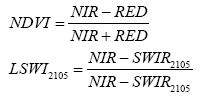
ρ NIR=reflectance of band NIR (0.870 μm)
ρ RED=reflectance of band RED (0.66 μm)
ρ SWIR2105=reflectance of band SWIR (2.105 μm).
Methodology and algorithm
This algorithm is based on indicators LSWI2105 sensitive to moisture level in the flooding and transplanting and NDVI by increasing chlorophyll content and cover the rice plant. The results showed that during rice planting due to flooding land LSWI2105 index rises and after growing its value decreases So that at the same time NDVI shows the opposite behaviour. At first t, pixels of five primaries image that LSWI2105 index was higher than NDVI isolated by using the first condition. In this condition, where LSWI2105 has been more than NDVI at time t is selected in the picture and this will continued until 4 times later. Thus the areas those reflective indexes were more sensitive to moisture isolated. So in this area we have had Paddy rice, blue areas (wetlands, ponds, etc.) and other areas that have a lot of moisture. As a result of this process produced a mask as an image. In conditions (4) and (5) of the algorithm pixels that had Minimum NDVI values between 5 primary images to be considered as flooding and transplanting pixel and The second image after that NDVI values should reach more than half of the maximum NDVI of pixels, That the condition (5) was isolated. In this condition NDVI value at time t is less than 2 images before and after, As well as NDVI value in the second image after time t is over half the maximum NDVI. Figure 3 shows the algorithm of the method used in the current study.

Figure 3: Algorithm used in this study.
Isolation paddy rice
According to the hypothesis presented in this section in order to identify the rice paddy, the algorithm has been developed for the separation and isolation of these regions. There are many factors that can be effective in the implementation of identification paddy rice algorithms which include snow cover, the body of water and vegetation. Therefore, these factors should be the mask of time-series images.
Permanent water
Standing waters are one of errors in the identification of paddy rice. The first two months of growing season paddy rice and water body are not separable. Rice paddy fields are as flooding only a short time during the period of growth, however the rest of the growth period paddy fields are with water but most reflect its canopy due to high density. At The first two months of growing season value of LSWI 2105 index is more than NDVI index and then the difference is shifted So that by the end of the growing season value of NDVI is more than LSWI2105, while LSWI 2105 for permanent water throughout the growing season is more than NDVI . The mask was produced using the following equation to remove the permanent water. Therefore, we have this result: [NDVI (t5)
Evergreen cover
In order to avoid errors caused by flooding natural vegetation in the separation of paddy rice, Evergreen vegetation were separated by NDVI and LSWI2105 indexes. Natural evergreen Coverage are normally combination of evergreen trees and shrubs. The first step is to identify evergreen forests. Forests of evergreen had high NDVI values over the year; while pixels of agricultural land (such as rice) a little period and the end of the harvest have had high levels of NDVI. Evergreen forest pixels can be detected from pixels that have a higher NDVI value of 0.6 during the year. The second step is to identify evergreen shrubs that normally the leaf area index (LAI) or NDVI is less than evergreen forests. Agricultural land usually are with bare soil such as (postharvest or time to prepare the ground),the index LSWI2105 value is very low at this time. After testing the hypothesis of LSWI2105 on the types of vegetation of Amol city throughout the year, the results showed that areas with vegetation fixed (with green cover during the year) have LSWI2105 rarely less than 0.15. Therefore, in this study pixel that LSWI 2105 value not less than 0.15 throughout the year known as natural evergreen vegetation [22].
Algorithm
Pixels in the first five years of images that were the LSWI2105 values more than NDVI identified and those pixels that the NDVI index has a minimum value considered as saturated and transplanting pixels. If these pixels in the second image after transplanting date had values more than half of their maximum NDVI, identified as pixels rice (Figure 4).

Figure 4: Results of Algorithm.
Digital elevation model (DEM)
Digital elevation model (DEM) with a spatial resolution of 30 meters derived from Aster satellite were prepared to determine the height of regions in the study area. DEM data were used to reduce the impact of altitude and to estimate the slopes in the paddy rice fields. Most paddy rice cultivated areas are located in areas with low slopes. So the mask is made of a digital elevation model and by using it areas with elevation higher than 1000 meters were removed. According to Haraz Basin Agricultural Development Project, the height to 100 meters is Plain region, from 100 to 500 meters above sea level is central zone, and more than 1,100 meters altitude are among mountain regions. So the mask is prepared with digital elevation model and the areas with altitude above 1000 m are removed (Figure 5).

Figure 5: Digital elevation model (DEM).
Permanent water
The mask was produced using the following equation and permanent water was separated by using it (Figure 6).

Figure 6: Permanent water.
[NDVI (t5)
Evergreen cover
According to the explained assumption, pixel that did not have had LSWI 2105 value less than 0.15 throughout the year known as natural evergreen vegetation and result is shown in Figure 7.

Figure 7: Evergreen cover.
Isolation rice paddy
Finally, after these factors were masked the result of the algorithm, rice paddy areas were identified and results are shown in Figure 8.

Figure 8: Rice paddy areas.
The distribution maps of rice paddy were separated from LANDSAT based on assumptions provided. Since the Map of agricultural land with separated crops does not exist from the provinces on a national scale, thus, the spatial distribution of rice paddy field in the province of Mazandaran and Guilan is not available.so Assess the accuracy of these maps were madeby using the control points that taken with GPS. During field operations there were a total of 56 field control point for the city of Amol in 1393 Including 26 control points of rice paddies and 30 control points of non-rice lands. At first the pixels of five initial images that LSWI2105 values were more than NDVI separated.
In the next step of the algorithm, pixels that had minimum NDVI values between 5 the initial image separated as flooding and transplanting pixel and in the second image after the picture if values of NDVI has been more than half the maximum amount of NDVI that pixel will be identified and isolated pixels as rice.
Our results were validated with ground field works data at 56 well-distributed sample points. The overall accuracy of this method is 69.0909% respectively. The results of this study indicated that the paddy rice mapping based on LANDSAT8 could potentially be applied at moderate spatial scales to monitor paddy rice agricultural fields on a timely basis.