Journal of Geography & Natural Disasters
Open Access
ISSN: 2167-0587
ISSN: 2167-0587
Research Article - (2025)Volume 15, Issue 1
This study assessed at the same time determined participatory land use planning in resolving resources use conflicts in Hai and was guided by three objectives, which were: To examine people perception about participatory land use planning, to assess the problems facing leaders in solving land resource conflicts and to identify measures to be taken in order solve land resource conflicts. The study was employed both quantitative and qualitative research designs. Data and information was obtained through administration of questionnaires at Hai district. The data collections were through questionnaires and interview.
Conceptual frame work; Research questions; Scope
UNEP: United Nations Environment Programme; GIS: Geographic Information Systems; GPS: Global Positioning System; M and E: Monitoring and Evaluation; NGO: Non-Governmental Organization; PLUM: Participatory Land-Use Management; PLUP: Participatory Land-Use Planning; RB-COSOP: Results-Based Country Strategic Opportunities Programme; VLUM: Village Land Use Management
This chapter deal with background, statement of the problem, research questions, significance of the study, scope and delimitation of the study, theoretical frame work, conceptual frame work and operational definition of the key terms [1].
Background of the research problem
Ramankutty et al., point out that people have been involved in inducing land cover change since the beginning of human history. Today, about one-third of the world’s land cover was devoted to agriculture, one third to forests and one-fifth to savannas, grasslands and shrub lands. While the global area devoted to crops has changed only modestly in the past 50 years, the distribution of these croplands has changed much more dramatically.
Indeed, global land cover change accelerated to unprecedented levels during this time period and this, in turn, has had consequences for the associated ecosystem services available at local, regional and global scales. Much of the cropland expansion during the past half century has been in the tropics.
There is evidence that the cropland expansion in the tropics has come at the expense of closed tropical forests. These areas are particularly rich in biodiversity as well as carbon. And others still rely on hunting and gathering for a significant portion of their income and/or sustenance. Efforts to increase the provision of land-based public goods affected these households directly, when they are either displaced or when they are paid for providing these services themselves. There are also important indirect effects that arise when the overall availability of land is altered, thereby affecting food prices and rural employment opportunities.
This paper begins with an overview of how global land use and the associated public and private goods and services are likely to change over the course of the 21st century. It then offers an in-depth analysis of key, land-based public goods, including carbon sequestration, bioenergy, biodiversity and institutions to facilitate climate adaptation, including information and analysis tools to adapt to the changing environment. The paper focuses on areas where under-provision of these public goods was likely and in such cases, it discusses the potential for public policies, research and development assistance to enhance their provision.
A report from Chiang Mai University indicates that recent population growth in the middle zone has created pressure on the region's natural resources (forest, land and water). During the last two decades, there has been a migratory flow away from both the highlands and lowlands into the middle ecological zone. This phenomenon has been experienced in many areas within the nine provinces of the upper north. The karen, being the major group of this zone, is particularly affected. They have been driven into ever more marginal highland slopes and narrow valleys. All ethnic groups are now competing with each other to survive under these harsh environmental conditions.
A resettlement programme and some highland development operations have created a flow of Hmong, Lisu, Lahu and Yao into the intermediate areas, some ethnic families who traditionally cultivate swidden crops, opium and corn, have resettled in the deserted villages of the Karen. The migration of these groups is a gradual process. After a few years, the migrants tend to change their pattern of forest/land-use. Many Hmong have bought irrigated rice fields from the Karen and have eventually occupied whole villages. A pattern of migration of poor and landless lowlanders into the middle zone is also apparent. For karen communities, this process has created a sandwich like condition. An over exploitation of forest land and disputes between ethnic communities is becoming increasingly aggressive and obvious.
Across much of Africa, participatory land use resources was concern about growing over an emerging ‘land grab’, whereby local communities loosed control over and access to the territories and natural resources upon which their livelihoods depends on. This surging competition over land and resources amongst local, national and international groups of people was being driven by a range of political and economic forces operating at these multiple scales. Development strategies that reconcile emerging conflicts over land and natural resource use and which provide local communities with secure rights and tenure, will be increasingly critical in the near future in light of these trends.
In Africa land conflicts existed in South Africa known as Apartheid Africa nation in1980-1990's where former president of Tanzania involved in solving conflict then led to social, political and economic development in South Africa. Land continues to have major historical, cultural and spiritual significances.
Northern Tanzania, with its rich savannahs, grasslands and montane landscapes and diverse array of farmers, pastoralists and hunter gatherer communities, has long been subject to competition amongst groups of people over land and resources. During the past century, the loss of extensive areas of land to external interests such as large scale commercial farms or state protected areas devoted to wildlife and tourism has had a major impact on northern Tanzania’s indigenous communities. Legal and policy measures propagated during the colonial and post-colonial periods have often served to expropriate local resources or have failed to recognize traditional systems of land use based on common property management, such as transhumant pastoralism. Promoting external commercial investment remains a major national policy objective and often comes into conflict with local livelihoods dependent on the use of natural resources such as water, soil, pasture, forests and wildlife. Local communities in northern Tanzania, as in many other parts of sub-Saharan Africa, need means of securing rights and access to land and resources and of resolving conflicts over resource use. Since the late 1990's, the Ujamaa Community Resource Team (UCRT) has worked with a wide range of communities across northern Tanzania to help local people secure 4 gatekeeper 147: December 2010 rights over lands and resources and to strengthen local management institutions. One of the main strategies for pursuing these aims has been through a process of Participatory Land Use Planning (PLUP), based on Tanzanian laws and policies.
Also in Tanzania they used to introduce land use planning with different sectors. For example agriculture policy 1997 whose aim to promote your integrated and sustainable use and management of natural resources like land, water and vegetation so as to conserve environment. National land policy 1995 which states land use planning will be done in participatory manner to involve beneficiaries. Tanzania forestry policy 1998 aimed at enabling participation of all stakeholders in forest management and conservation. Therefore through introducing policy that favor the users and stakeholders to involve in decision making on certain land use in Tanzania.
In local level the villagers participate fully in agenda setting resource allocation and controlling the planning process. Capacity of local decision making is built through mobilization of local institution and knowledge. The process of information gathering and analysis, priority setting) and the formulation of village plans local people centered, flexible and fosters collaboration both all sectors. This help the users to be aware on the issue of land ownership as each get his or her defined area this help to avoid conflicts among the users.
In Hai district the land is as important as many people depend much on land for production. Huge populations are farmers and pastoralists. Through increasing of demand to the farmers and pastoralists this accelerate to land use conflicts. In Hai district also land conflicts occurred starting from June to November in 2009 this is among the farmers and pastoralists this caused by lack the right to own land through that conflicts UNDP as well as Tanzania introduce land use planning so as to conserve the environment [2].
Statement of the research problem
The problem of this study was the role of participatory land use in resolving resources use conflict in Hai district. Participatory land use planning introduced to improve management on land resource use. The driving force in planning is the need for change the need for improved management or the need for a quite different pattern of land use dictated by changing circumstances. Participatory land use planning involve the local leaders and local people that was farmers and pastoralists in decision making in Hai district involve district leaders, ward leaders and village leaders with pastoralists and farmers in decision making about land use. Through implementing participatory land use planning in Hai district help to resolve conflict that occurred in 2009 where by people fight due to land resources so through participatory land use planning all the users participate in decision making and get their defined area this make an end of conflicts.
Objectives of the research problem
General objective of the research problem: To assess the participatory land use planning in resolving land resource use conflicts at Hai district.
Specific objectives of the research problem
• To examine people perception about participatory land use planning at Hai district.
• To assess the problems facing leaders in solving land resource conflicts at Hai district.
• To identify measures to be taken in order solve land resource conflicts at Hai district.
Research questions
• How do know about participatory land use planning at Hai district?
• What are the problems facing leaders in solving land resource conflicts at Hai district?
• What are the measures to be taken in order solve land resource conflicts at Hai district?
Significance of the study
This study helpful to the government or local government or village government and stakeholders or users that was farmers and pastoralists in taking action to solve different resource use conflicts as well as the ways use by the farmers, peasants and pastoralists to participate in land use planning. The engagement of the land users enable the researchers to acquire effective information concerning the role of participatory land use planning in resolving resources use conflicts. The inclusion of the local leaders in this study provided the researchers to get genuine information on the importance of participatory land use planning because are the responsible on conflict management.
Scope and delimitation of the study
The study was conducted at Hai district because they faced with land resource use conflicts in July to November in 2009 between peasants, farmers and pastoralists. The participants are the users of land resources and the leaders of that place, through using participatory land use planning helped to solve land resource use conflict. The engagement of the land users enabled the research to acquire effective information concerning the role of participatory land use planning in resolving land resource use conflicts.
The inclusion of the local leaders in this study provided the researchers to get genuine information on the importance participatory land use planning because are the responsible on conflict management.
Conceptual framework
This section was detailed with conceptual frame work that guide researcher. Land users mostly farmers and pastoralists as well as local leaders. Therefore there is close relationship between participatory land use planning and resolving land resource use conflicts. The independent variables influenced the success of dependent variables as illustrated in frame work (Figure 1) [3].

Figure 1: Conceptual framework.
Definition of key terms
Participatory land use planning: Is an interactive process in which local communities could discus and determine how to manage the land and other natural resources in their locality?
Land use planning: It involve the allocation of land to different use across a landscape in a way that balances economic, social and environmental values [4].
Conflict resolution: Is the a way for two or more parties to find a peaceful solution to a disagreement among them.
Natural resource conflicts: Are the disagreements and disputes over access to and control and use of natural resources, examples of natural resources are forest, water pastures and land [5].
Participatory development theory
According to Washboard participatory theory criticized the modernization paradigm on the ground that it promoted atop down ethnocentric and paternalistic view of development. They argued that the strategies model proposed a conception of development associated with a western vision of progress. The approach of persuading model implicitly assumed that the knowledge of government and agencies was corrected that indigenous population went either ignorant or had incorrect beliefs, Cypher and Diethz [6].
A host of development scholars have begun to answer this challenges articulating a concept known as active involvement of people in making decision about implementation of process, programmes and projects which affect them.
Roodt and Dodds have voted that the participatory development approach stressed the participation of the majority of the population especially the previous excluded components such as cobs, women and illiterates in the process of development program. This theory views development as a process which focuses on community's involvement in their own development using variable resources and guiding the future development of their own community. This concept involves capacity building, empowerment, sustainability, equal partnership [7].
Strength of participatory development theory
Building democracy through participatory development theory people be involved in decision making on the issue of land use planning since people living in a certain community be aware. About land resources and the measure to control that resources also help to increase high productivity this can be achieved after offering awareness on land use planning on different resources in a certain community as the farmers or pastoralists can be able to practice agriculture in a specified area which is favorable to that agriculture activities also it help to reduce cost and increase efficiency through participatory theory help to avoid losses since activities performed according certain land use in given community.
Weaknesses of participatory development theory
The theory failed to show other groups who are not involving in decision making those groups include women and their children in allocating land resources in their areas as they become discriminated when a people of a certain village or place make a decision about land use resources.
Also this theory failed to show the challenges facing those people involved in participatory land use. For example the occurrence of conflicts if land use planning not managed well or presence of biasness.
Relevant to the study
This theory is so relevance also so current to my study since explain more about participatory as the tool to sustainable development simply because through participatory in land use planning this will help to avoid conflicts and improve sustainable development. Also this theory explain the cooperation among the leaders and the stake holders when they participate equal in decision making about land use planning.
Institutional land use planning theory
The institutional land use planning theory is described by north as the role of institutions set up by municipalities to manage land use present in their respective areas. The theory was developed by North. North observed institutions from land use point of view that were the rules of the game in a society. The theory based on the conception that individuals are socially constructed identities. The theory challenged the neo classical theory which assumes that the political, economic and social surroundings is composed of groups of independent individuals, each practicing their own preference in order to get hold of material fulfillment.
The theory relate with this study by showing the role of municipalities in managing land use in cooperation with the other institutions where the high number of people or population may be found such as schools, markets, hospitals and industries.
Strength of the theory
The theory provides different ways of seeing and knowing the land use planning and ways of acting in it are understood or constructed in political, economic and social relations with others. Also the theory tries to assess the understanding that no institution that can exist on it’s entirely but through interaction with others.
Weaknesses of the theory
The theory did not show the contribution of the institutions in controlling and management of land use. Although in other side the institutions and other sectors played a role in land use management through payment of land fee collection.
Empirical review
Kisiza conducted a study on empirical analysis of resource use conflict between small holder’s farmers and pastoralists in semiarid areas in Mkata Plains Eastern Tanzania. He explained that presence of resources use conflict. This attribute to the face that village government had recently formed conflict resolution, also he discovered that crop damage, excessively large herds of cattle’s, herds violating boundaries, farmers disregarding village boundaries, government officials favor farmers those are the issues that caused conflicts.
Gelas Rubakula conducted a study on land conflict management through the implementation of national land policy in Tanzania evidence from Kigoma region analyzed that male and female participating in land management issues like holding titles owning surveyed land, engage in land use planning and performing socio-economic activities analyzing the factor associating conflicts possessing land title, shifting cultivation and the nature of the land acquisition.
Nsia Humprey and Peter A. Kopoka conducted a study in contribution if local leaders towards land conflict management in Tanzania a case study in Monduli district. He discovered that the conflict occurred due to increase of population is weak awareness campaigns and lack of clear boundaries. Therefore he suggested that the information about land use planning should not be biased all people in a community should participate equal so as to avoid conflicts conducted a study on participatory land use planning and conservation Northern Tanzania range lands. Through his finding discovered that people were not involved in planning process also they don't know what land use planning mean. Also discovered that all these caused by factors like lack of plan implementation, lack of kind use zone law, lack of sustainable planning process and preparation plan according to the wishes of clients those are the major problem in Tanzania.
Ndimo report that most of the developed countries have well organized land use systems, by setting area special for collection of solid waste and provided in curb to collect solid waste. Different colored collection bins are placed in curbs for different types of waste materials. These collection bins are also provided for recyclables such as glass, cans, plastic bottles etc. Communities carry waste and put in these containers. These recyclables are later removed and used for recycling industries, curbside collection. System is efficient in many developed countries. Wastes are carried out from house and are placed in curb with different colored bins. These wastes are later picked by collection vehicles. These vehicles are single compartmented and multi-compartmented to collect recyclables separately.
Satihal was conducted a study in Karnataka state, India on impact of population growth on land utilization, which offers an appropriate case study, for it has been under the influence of rapid demographic and agricultural changes for the last several decades. The analysis of the demographic data revealed that the population is growing rapidly with fluctuating growth rates in different decades. The population in the state had quadrupled during the last century. Though it has been noticed that there are some indications of declining growth rate, the current population of the state is still growing every year by 2.01 percent per year this will leads to the increase of land resources conflicts. In view of the limited natural resources in the state, further increase will have serious consequences on land use. The researcher studies based on the impacts of population growth on land utilization and defining how the increase of human population is differing from other decade and cause the impacts on land use. The researcher did not tell us about those impacts caused by human population growth on agriculture and show it globally.
Currently there is the high number of land use conflicts compare to the past and this can lead to the impacts in agriculture sector which are negatively and positively such as innovation of tools like tractors which can be simplify work and increase land conflicts (Table 1) [8].
| Author | Year | Themes | Strength | Weakness | Relevance |
|---|---|---|---|---|---|
| Gelas | 2019 | Conducted a study on land conflict management through the implementation of land policy in Tanzania | He explain the presence of resource conflict | Not true that all male and female participate equally in land management issues | Objective number 2. To assess the problems facing leaders in solving land resource conflicts |
| Abiud Kiswahili | 2018 | Conducted a study on participatory land use planning and conservation in northern Tanzania land. A case study Monduli | Explained the factors that cause people to be unaware on land use planning | Failed to explain the techniques of solving the problem of land us conflict | Objective number 3 |
| Nsia Humprey and Peter A. Kopoka | 2016 | Conduct a study of the contributions local leaders towards land conflict management in Tanzania | Explained that conflicts occurred due to increase of population and lack of boundaries | Failed to explain the role of government policy and laws in solving land use conflicts | Objective number 1 |
Table 1: Summary of empirical review.
Demonstration of knowledge gap
King, he conducted a study on conflict management among the farmers and pastoralists in Tanzania qualitative case study design has been used to explain the period when conflict occurred. Also use interview where the leaders tried to explain the source of conflict and the measures taken. Kisoza, conducted a study on empirical analysis of resources use conflict between small holder’s farmers and pastoralists in semi-arid areas in Mkata plains Eastern Tanzania. He used a simple random sampling where 55% accepted that in the area there are resource use conflicts [9].
The above literature review tried to show the sources of conflicts in land use resources like large herds of cattle’s, government officials favor farmers and absence of clear boundaries between farmers and pastoralists also the measurement taken in resolving land resource conflict. They use qualitative case study design, structured interview also empirical analysis. The study will be conducted in Kilimanjaro region specifically at Hai district in assessing the participatory land use planning in resolving resource use conflicts [10].
This research design and methodology of the study which comprise of research design, description of the study area, targeted population, description of sample and sampling techniques, description of data collection instruments, description of data collection procedures and description of data analysis procedure, ethical consideration and rationale for selecting the study area [11].
Research design
Research design was the plan of the research study, it was the overall strategies that used by researcher to gather different data about the study in order to solve the problems. The study used a descriptive survey design. This is because the study requires collecting quantitative and qualitative data and thus researching questions which guided the study to capture both qualitative and quantitative information.
According to Kombo, descriptive design attempt to collect data from a sample of a population in order to answer questions concerning the current status of the population with respect to one or more variables. Hence the descriptive survey design was appropriate since the aim of the study was to assess participatory land use planning in resolving resource use conflicts in Hai district.
Description of the study area
Hai district is one of the seven districts of the Kilimanjaro region of Tanzania. It is bordered to the south and west by the Arusha region, to the west by the Siha district and to the east by the Moshi Urban district and Moshi rural district and the Rombo district (Figure 2).

Figure 2: Location of the study area.
Target population
This is the group of people or population which researcher was intended to gather information about the study undertaken, therefore in this sturdy the target population was households in Hai district are main users and interrupters of the land. Land planner officers that are main concerned of planning, conserve and protect as well as individuals whose interact with the land in one way or another in daily activities.
Description of sample and sampling process
The unit of analysis for this study was the household, land officers and individuals, sample was the small portion selected from whole population.
Sample size
Sample size was the total number of the selected respondents. It is selected depends on some factors like size of population, the nature of population and the kind of the sturdy. Therefore the study carried out at Hai district with sample size of 10% of total population. The sampling process based on the people who are conducting different social and economic activities together with the land planner officers in order to accumulate reliable information [12].
The sample size determined by the following:
This formula was applied to total population of Machame East ward so as to determine the sample size reliable to provide the information of the research.
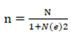
Description of the formula
n=Sample size
N=Total number of house holds
e= Precisions level
Data of the total population in the ward Machame East 13084, which includes three villagers which were,
• Lyamungo Kati
• Lyamungo Sinde
• Lyamungo Kilanya
General total of population of those three villager are=13084.
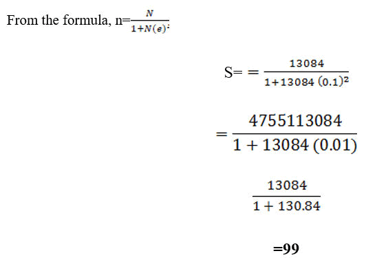
Therefore, this research used the sample size of 99 respondents
Description of sample and sampling procedures
A sample of sixty participants was selected through simple random sampling and stratified random sampling, the sample included 3 land officers in which one was selected from each village and 3 village leaders was selected from each ward and 93 villagers were selected randomly from each ward and gave the total of 99 people.
Data presentation and interpritation
This chapter consists of general characteristics of the examined respondents which included, gender, age, marital status and level of educational. Also this chapter consists of the specific objectives such as to examine people perception about participatory land use planning, to assess the problems facing leaders in solving land resource conflicts and to identify measures to be taken in order solve land resource conflicts to examine people perception about participatory land use planning.
Demographic information of the respondents
This section present demographic characteristic of respondents in terms of gender, age, marital status and level of educational, this information is important to know as it provides the general information about the land resources stakeholders and the participatory land use planning in resolving land resource use conflicts.
Gender of respondents
The research study was done by the population of both sex, male and female, the research aimed to secure information about gender and how it influence to the participatory land use planning for resolving resources use conflicts (Figure 3).

Figure 3: Genders of respondents.
From the Figure 3 above show that 47 (47.47%) of the respondents in the study area were male whereby about 53 (52.53%) of the respondents were female. The study noted that the majority of the respondent in the study area were female indicating that female are mostly involved in those activities related to land resources rather than male [13].
According to Tessema, the genders of the people living at the particular area have a great influence on the condition of the land, female tend to conduct very destructive activities such as agriculture and compared to male.
Age of respondent
This research study was supported by the respondents of different ages from 20 years and above, the table below shows the age distribution (Table 2) [14].
| f | % | |
|---|---|---|
| 20- 29 years | 32 | 32.3 |
| 40-59 years | 43 | 43.4 |
| 60 years and above | 24 | 24.2 |
| Total | 99 | 100 |
Table 2: Age of respondents.
The results from above Table 2 shows that the majority of respondents were aged between 40-59 years age group which represent 43 (43.4%), followed by 20-29 years representing 32 (32.3%) the next age group was 60 years and above which represents 24 (24.2%), of 99 respondents used in this research study. This implies that the age groups of 40-59 years have more encouraging in land resource and understanding than other age groups.
Furthermore according to Waeber, at the household level demand for land resources products is determined by d emographic factors including household size, composition and age structure, whereas the middle age tend to utilize land resources than the younger and older ones.
Marital status and level of education
The respondents involve in this study comprised of different marital status and education level, the table below show this (Table 3).
| Marital status | Single | Married | Divorced | Separated | Widow | Total | |
|---|---|---|---|---|---|---|---|
| Level of education | Primary | 4 | 10 | 1 | 2 | 9 | 26 |
| 4.0% | 10.1% | 1.0% | 2.0% | 9.1% | 26.3% | ||
| Secondary | 6 | 33 | 0 | 3 | 1 | 43 | |
| 6.1% | 33.3% | 0.0% | 3.0% | 1.0% | 43.4% | ||
| Colleges/University | 13 | 11 | 1 | 3 | 2 | 30 | |
| 13.1% | 11.1% | 1.0% | 3.0% | 2.0% | 30.3% | ||
| Total | 23 | 54 | 2 | 8 | 12 | 99 | |
| 23.2% | 54.5% | 2.0% | 8.1% | 12.1% | 100.0% | ||
Table 3: Show marital status and level of education.
From above the field research found that about, single were 4.0%, married were 10.1%, divorced were 1.0%, separated were 2.0% and widows were 9.1% at education level of primary, at secondary schools single were 6.1%, married were 33.3%, divorced were 0.0%, separated were 3.0% and widows were 1.10%, at college/university single were 13.1% married were 11.1%, divorced were 1.0%, separated were 3.0% and widows were 2.0%. The study noted that the majority of respondents were married which about total of 54.5% of the respondents, furthermore the find found that majority of respondents were secondary level of education were by total were 43.4%. This imply that married one they use at large the land resources this may be due to the high need of consumptions by their family which tend to utilize at large quantity the products of land resource, apart from that respondents who have second education they utilize land resources at large than other groups.
The similar study was conducted by Mayeers, who said that land resources contributes to the provision of fuel wood for the about 80% of the population in Tanzania and the most extractor of that fuel wood are married and the people who have low income level.
According to Odgaard, the allocated rights are customary in the sense that they are not formally registered and that rules for use are in accordance with local norms and customs and village bylaws. They are considered as secure as other customary rights as long as they are locally recognized and seen as legitimate by the villagers in general. Married women are generally not allocated land without the consent of their husbands. Some single and divorced women have though been allocated land by the authorities, but generally claim that it has been a very difficult process.
Perception on participatory land use planning
This research study used to investigates the perception on participatory land use planning at Hai district as seen in the questions below.
Participatory land use planning
This part aimed at examining if the participants know about land use planning (Figure 4).
From Figure 4, show that the data collected from the field area majority about 84.8% of the respondents they know about the participatory land use planning and few respondents about 15.2% they dint know about participatory land use planning. The study revealed that the majority of the respondents in the study area have wide knowledge of participatory land use planning. Also the similar data was provided by the land officer and villager leader who said that is different seminaries which communities get about land use planning. This study is likely to be similar with the study conducted by HADSON, who said that seminaries is major to the communities for changing their attitude about land use planning it makes them more aware about the good ways of land use planning.

Figure 4: The participatory land use planning.
Source of knowledge about participatory land use planning
The respondents were asked where they got knowledge of participatory land use planning. Figure 5 shows the response of respondents.

Figure 5: The source of knowledge of participatory land use planning.
Results in above Figure indicate that, 38.4% of respondents got knowledge of participatory land use planning through television, 24.2% got through and office and planners and 37.4% got through village leader. The study noted that many of respondents are watching television and is the sources were they get that knowledge. This implies that they are lack of expertise that can provide the knowledge of participatory land use planning to the communities. This was not surprising as, Nazari and Hasbulallah, also found that, the television and radio is an effective source for disseminating the latest knowledge and information or technology to communities.
Participation in land use planning
The research was investigating if the community participates in land use planning in their area; the figure below shows the respondents of participators (Figure 6).
Results in Figure 6 above indicate that, 75.8% of the respondents were participated in the land use planning in their area while 24.2% were not participated. This imply that community have a knowledge of land use planning and also the leaders are encouraging their people to participate in land use planning in order to avoid some unnecessary conflicts. Likely results were obtained by Lwoga who reported that land use participatory method must be applied in order to improve productivity and the quality of their produce, farmers must have wide knowledge and must participate in their area for the land use planning to plan for agricultural activities. Development strategies that reconcile emerging conflicts over land and natural resource use and which provide local communities with secure rights and tenure, have increasingly critical in the near future in light of these trends. Furthermore interview with land officers and village leaders said now day’s minister concerned the land have a programs of providing education to the communities about land tenure and registration of land to the owners which help to reduce the land conflicts.

Figure 6: The participation in land use planning.
The problems facing leaders in solving land resource conflicts
This section focused on assessing the problems facing leaders in solving land resource conflicts (Table 4).
| There are any land use conflicts in your area? | Yes | No | Total | |
|---|---|---|---|---|
| Is already solved? | Yes | 69 | 1 | 70 |
| 69.7% | 1.0% | 70.7% | ||
| No | 23 | 6 | 29 | |
| 23.2% | 6.1% | 29.3% | ||
| Total | 92 | 7 | 99 | |
| 92.9% | 7.1% | 100.0% |
Table 4: There are any land use conflict in your area is already solved?
The field research from above Table, found that 92.9% of the respondents said there was a land use conflicts in their area while 7.1% said there is not land conflicts in their area. Furthermore 69.75 they said the land conflicts in their area were already solved and 29.3% they said the land conflicts was not yet solved. The study noted that now day’s government leaders were trying the best level to solve land conflicts in the country, hence make to have few conflicts in the study area. Wehrmann, observes that there was few land conflicts in Kongwa district at Dodoma this is due to the power of the one of the pillar of government which involved in resolving that lands resources conflicts between pastoralist and farmers.
Problems facing leaders in solving land resources conflicts
The researcher was aimed to secure the information from the participants about the problems facing leaders in solving land resources conflicts from participatory land use planning and below were the responses of respondents (Table 5).
| Strong agree | Agree | Neutral | Disagree | Strong disagree | Total | |
|---|---|---|---|---|---|---|
| f% | f% | f% | f% | f% | f% | |
| Shortage of knowledge | 65 | 27 | 6 | 1 | 0 | 99 |
| 65.7% | 27.3% | 6.1% | 1.0% | 0.0% | 100.0% | |
| Scarcity of land tenure | 64 | 20 | 14 | 1 | 0 | 99 |
| 64.6% | 20.2% | 14.1% | 1.0% | 0.0% | 100.0% | |
| Lack/inappropriate land use policy | 38 | 38 | 22 | 1 | 0 | 99 |
| 38.4% | 38.4% | 22.2% | 1.0% | 0.0% | 100.0% | |
| Unavailability of fertility land | 15 | 30 | 39 | 12 | 3 | 99 |
| 15.2% | 30.3% | 39.4% | 12.1% | 3.0% | 100.0% |
Table 5: The problems facing leaders in solving land resources conflicts.
Shortage of knowledge
The study from above Table, found that about, 65.7% of the respondents strongly agreed that shortage of knowledge is among the problems facing leaders in solving land resources conflicts, 27.3% agreed, 6.1% were neutral, 1.0% disagreed and 0.0% strongly disagreed. The study noted that there is lack of knowledge to the communities which makes it difficult for leaders to solve land resources conflicts. Like the study conducted by WHO, they said that communities are not involved in land resource management due to the lack of knowledge among tropical countries. Moreover, interviews with land officers revealed that it is difficult to cover the whole area because of funding constraints, leading to knowledge gaps in the community regarding land resource management.
Scarcity of land tenure
From above Table results also show that 64.6% of the respondents strongly agreed that scarcity of land tenure is among of the problem facing leaders in solving land conflicts to the communities, 20.2% agreed, 14.1% were neutral, 1.0% disagree and 0.0% were strong agree. This study noted that land tenure is the big problem facing community which leads to the conflicts between pastoralists and farmers in many areas, furthermore this implies that there is shortage of education to the community about the importance of having land tenure. Wily and Shem, reported that due to the fact that the President serves as a legal trustee for others, he cannot act like an ordinary landowner and the actions he can take are formally limited to those that are in the public interest that is something that helps the nation but in other side it lead fear to the community to have land tenure because there are not sure at if government cannot interfere.
The similar data was provided by land officer and village leaders who said that there is little participation of the local people for finding the land tenure or land titled deed this also increase the land resources conflicts to the community.
Lack/inappropriate land use policy
Results from above Table also show that 38.4% of the respondents strongly agreed that lack/inappropriate land use policy is among the problems facing leaders in solving land conflicts in the study area, 38.4% agreed, 22.2% were neutral, 1.0% disagreed and 0.0% strongly disagreed. The research noted that land use policy does not correspond with the current realities in communities, making it difficult for leaders to resolve land resource conflicts. A similar result was obtained by Ogboma, who noted that farmers do not know where to get help because government leaders follow outdated land policies that do not reflect the real situation.
Furthermore, the Land Acts of 1999 distinguish between two types of registered land rights: granted right of occupancy (usually urban) and customary right of occupancy (usually rural). While both are secure, customary rights may be indefinite, whereas granted rights are limited to up to 99 years.
Unavailability of fertility land
Result in above Table shows that 15.2% of the respondents strongly agreed that unavailability of fertile land causes the occurrence of land resource conflicts, 30.3% agreed, 39.4% were neutral, 12.1% disagreed and 3.0% strongly disagreed. The study noted that increasing scarcity of fertile land and conflicting interests among land users have led many people to migrate in search of arable land and pastures elsewhere. Marginal lands in semi-arid regions with erratic rainfall are now increasingly being used for cultivation. The problem is worsened by the inability of people in these areas to afford inputs to maintain or improve soil fertility. Nielsen et al. and Odgaard et al. reported that the unavailability of fertile land leads to cultivation spreading into marginal areas and reduced access to grazing land, which in turn increases conflicts between different interest groups and land use types.
Measures to be taken in order to solve land resource conflicts
This part aimed to identify measures to be taken in order solves land resource conflicts. The study concentrated on the following questions.
Participatory land use planning helps in resolving land use resource conflicts
The question was asked to the respondents if participatory land use planning helps in resolving land use resource conflicts in their area. Figure 7 shows the responses of the respondents.
Research findings from Figure 7 above show that 70.7% of the respondents said participatory land use planning helps in resolving land use conflicts in their area, while 29.3% of the total respondents said participatory land use planning does not help. This study noted that, to a large extent, communities are aware of participatory land use planning. This implies that there is good direct involvement of the community on issues related to land use in their places. Furthermore, an interview with one of the village officers stated that there is a good system established by the government which enables communities to be involved in all land-related issues at the village level. This study aligns with findings by HADSON, who stated that the current reduction in land conflicts is largely due to increased awareness and the extensive participatory system established by the government.

Figure 7: The respondents on participatory land use planning helps in resolving land use resources conflicts.
Measures to be taken in order to solve land resource conflicts
The respondents were asked to indicate the measures to be taken in order to solve land resource conflicts. Table 5 and Table 6 show the responses of respondents.
| Strong agree | Agree | Neutral | Disagree | Strong disagree | Total | |
|---|---|---|---|---|---|---|
| f% | f% | f% | f% | f% | f% | |
| Provision of education | 73 | 19 | 6 | 0 | 1 | 99 |
| 73.7% | 19.2% | 6.1% | 0.0% | 1.0% | 100.0% | |
| Policy implementation | 58 | 27 | 12 | 2 | 0 | 99 |
| 58.6% | 27.3% | 12.1% | 2.0% | 0.0% | 100.0% | |
| Legal security | 37 | 36 | 24 | 2 | 0 | 99 |
| 37.4% | 36.4% | 24.2% | 2.0% | 0.0% | 100.0% | |
| Land use master plan | 23 | 38 | 33 | 5 | 0 | 99 |
| 23.2% | 38.4% | 33.3% | 5.1% | 0.0% | 100.0% |
Table 6: Measures to be taken in order to solve land resources conflicts.
Provision of education
Findings in Table 6 above show that 73.7% of the respondents strongly agreed that provision of education is a major tool for resolving land resource conflicts, 19.2% agreed, 6.1% were neutral, 0.0% disagreed and 1.0% strongly disagreed. This study noted that a large portion of respondents (73.7%) said education is the key starting point for changing community perception on how to resolve land resource conflicts and understand their importance. This implies that leaders should focus more on educating the society. Kariuki stresses that land conflicts affect different groups in varying ways—having a stronger impact on the livelihood of the poor than the rich—and also affect men and women, urban and rural populations, farmers and pastoralists differently. Groups such as squatters, ethnic minorities or orphans are extremely marginalized, and these issues were minimized when education initiatives began to take place.
Policy implementation
The research findings in Table 6 above show that 58.6% of the respondents strongly agreed that policy implementation is among the effective measures for resolving land conflicts, 27.3% agreed, 12.1% were neutral, 2.0% disagreed and 0.0% strongly disagreed. This study noted that proper policy implementation within the society helps minimize land resource conflicts because policy establishes land use boundaries for communities. A similar study by Cavendish discussed how land resources contribute to community support. His work mentioned that land policy enabled good land management, which helped to eliminate some conflicts.
Legal security
Result from table above shows that 37.4% legal security like land titled deed, land Rights, legislations, respondents strong agreed that used to as measures in resolving land resources conflicts, 36.4% agreed, 24.2% were neutral, 2.0% disagreed and 0.0% strong disagree. This study noted that legal security is the strong measures to minimized the land resources conflict, apart from that the research imply that government have been using more power and have been employed many workers who are dealing with land resources management and the outcome it that the land conflicts are reduced.
Also this study revealed with Woodman, reported that the bodies of law related to land rights observed in Tanzania are unwritten customary laws on the one hand and on the other hand the ‘modern’ laws and policies, namely state laws written down in law books and government policies as they appear in written instructions, the press. Legal pluralism implies that when these bodies of law are legally applied in for example resolving cases of land disputes, the normative orders (local rules, norms and codes of conduct) observed by people in the empirical context where the dispute has occurred have to be taken into consideration and used as sources of law.
Land use master plan
The findings from the table above show that 23.2% of the respondents strongly agreed that the land use master plan is used as a measure to solve land resource conflicts, 38.4% agreed, 33.3% were neutral, 5.1% disagreed, and 0.5% strongly disagreed. This implies that a master plan helps society by allocating land for specific uses such as markets, hospitals, and sports grounds, which in turn helps resolve land resource conflicts.
Ojalammi reported that the land master plan program aimed at resettling people in villages with communal or cooperative production. In areas where the program was effective, local customary rights were formally extinguished, and traditional settlement patterns were radically altered. This resettling process helped resolve land resource conflicts in affected villages.
Citation: Syonga E (2025) Assessment of the Participatory Land Use Planning in Resolving Land Resource Use Conflicts at Hai District, Kilimanjaro, Tanzania. J Geogr Nat Disasters. 15:330.
Received: 14-Nov-2023, Manuscript No. JGND-23-28026; Editor assigned: 17-Nov-2023, Pre QC No. JGND-23-28026 (PQ); Reviewed: 01-Dec-2023, QC No. JGND-23-28026; Revised: 06-Jan-2025, Manuscript No. JGND-23-28026 (R); Published: 13-Jan-2025 , DOI: 10.35841/2167-0587.25.15.331
Copyright: © 2025 Syonga E. This is an open-access article distributed under the terms of the Creative Commons Attribution License, which permits unrestricted use, distribution, and reproduction in any medium, provided the original author and source are credited.