Journal of Geography & Natural Disasters
Open Access
ISSN: 2167-0587
ISSN: 2167-0587
Research Article - (2014) Volume 4, Issue 2
The purpose of this research paper is to identify watersheds with high flood potential based on watershed characteristics for formation of surface runoff. The SCS-CN method relies on remote sensing and GIS data for obtaining watershed characteristics. A 30 m raster grid size digital elevation model (DEM) has been generated from field survey using Global Positioning System (GPS) of 3 m accuracy integrating with Survey of India topographical maps of 1: 50,000 scale having 10 m contour interval. The undisturbed soil samples from field have been collected and laboratory analysis was carried out using modified proctor compaction test as per ASTM D1557 and sieve analysis as per ASTM C136. This has helped in establishing hydrological soil map while land use map has been prepared using Landsat 7ETM+ image band 2, 3, 4 [30 m] merged with PAN band 8 [15 m] for classification. The supervised classification approach using maximum likelihood classifier has been employed for preparation of land use map for Varekhadi catchment having 442 km2 of geographical coverage. The major land use categories classified on 10 Nov 2001 Landsat 7ETM+ image have been agriculture (32%), forest (29%), wasteland (20%), fallow land (14%), built-up (4%) and water bodies (2%). The hydrological soil groups generated in GIS environment have identified two soil groups viz. group B and group C that exist under study area. The Varekhadi catchment has been delineated into five watersheds viz. Amli, Zankhwaw, Visdaliya, Godsambha and Wareli delineated using DEM and stream network. The SCS-CN model was applied for estimating of daily run-off for each sub-watershed. The results obtained on the flood potential analysis shows that Wareli watershed has highest flood potential while the Amli watershed lowest. It should be noted that highest value of flood potential belongs to lowest part of watershed, where high population density can be found. This analysis reflects an increased vulnerability and risks to floods and inundations for Wareli watershed. Stream gauge data has been used for result validation with a common event of 2010 and it shows good fit with the model. The flood potential analysis within the lower Tapi basin tributary suggests that the SCS-CN method with hydrological parameters derived using remote sensing and GIS data can be applied to predict run-off in poorly gauged watersheds
Keywords: SCS-CN method; Remote sensing and GIS; Landsat 7ETM+; Runoff; Ungauged catchment
Surface runoff generation has been dependent on climatic, geo-morphological, topographical and landuse characteristics of a catchment or watershed. Of above, the topographical characteristics, and soil types with land use as hydrological soil group have been of immense importance. A combination of characteristics favourable for runoff generation and runoff concentration increases the flood potential in a watershed. Most of the watersheds in India have been poorly gauged or un-gauged, as they do not have adequate records of runoff generation for a rainfall event to understand the hydrological response. In the flood prone catchments, it is needful to calculate peak flood discharge or flood potential from each watershed. A number of discharge estimation methods available in the literature namely Rational method, Soil Conservation Service- Curve Number (SCSCN) method, Cook’s method and Unit hydrograph method. However, the SCS-CN method for predicting direct run-off or discharge from rainfall excess of ungauged watershed is extremely important. This method allows the identification and zoning of watersheds with a high risk of generating floods and of those exposed to runoff generation processes. Soil and landuse parameters which control surface runoff can be evaluated and mapped significantly through remote sensing satellite images. Sharma and Singh [1] in their research work for Luni river catchment have successfully used Landsat TM and SCS-CN model to estimate runoff potential. Katimon et al. [2] estimated flood potential of two small watersheds of Salengor and Pontian in Malaysia using SCS-CN method and GIS based empirical approach to predict daily event storm runoff. They have been of the opinion that SCS-CN and GIS has limitations of accurate flood estimation in absence of accurate hydrologic soil group data. They have noted large variations in the surface runoff if hydrological soil group changes. Later, Behzad et al. [3] used SCS-CN method for estimating flood potential for different return periods. They emphasised more on geomorphologic characteristics of Tarik flood basin in Iran. Several other methods on peak flood discharge and associated parameters estimation have been suggested in the literature for ungauged basins. Zhan et al. [4] has developed Arc-CN tool integrated with ArcGIS and applied SCS-CN method for estimating run-off and preparing CN and run-off maps. However, the parameter reliability between various methods varies to a large extent and none found to be suitable universally. In spite of few limitations SCS-CN along with hydrological soil group and land use remain to be a popular method for estimation of flood potential under poorly gauged or ungauged catchments due to its performance and reliability.
Soil Conservation Service-Curve Number model (SCS-CN) has been applied in the present study for the estimation of run-off from five watersheds of Varekhadi catchment- a tributary of Lower Tapi Basin. This SCS-CN requires information on numeric catchment characteristics related to DEM, land use, and hydrologic soil group for estimation of catchment runoff. The purpose of this method is to determine the curve number of the catchment accurately that assesses the estimated runoff potential. Hydrologic soil group, land use type, vegetation cover have been important physical characteristics of a watershed used for the calculation of curve number. Thus, the most important step in estimation of surface runoff or flood discharge is to calculate watershed characteristics accurately. Remote sensing and GIS data together with field surveys and field measurements have been input for classification of watershed characteristics. Landsat7 ETM+ image band 2, 3, 4 (30 m resolution) have been merged with PAN (15 m resolution) data for supervised classification of land use classes using Gaussian maximum likelihood classifier. Hence, the runoff curve numbers for different watersheds were determined using land use and hydrological soil group map within the study area.
Tapi river basin covers three states viz. Madhya Pradesh (9804 km2), Maharashtra (51504 km2), and Gujarat (3837 km2) having a geographical area of 65145 km2 and is the India’s second largest interstate westward draining River in Arabian Sea. The Tapi river basin can be classified in three zones, viz. Upper Tapi basin, Middle Tapi Basin, and Lower Tapi Basin (LTB). The area between Ukai Dam to Arabian Sea has been considered as LTB, mainly occupying Surat and Hazira twin city along with tens of small towns and villages along the river course. LTB have a geographical area of 2920 km2 which has been experiencing periodic floods in urban settlements of Surat and Hazira. The Surat city is almost 106 km downstream of Ukai Dam while Hazira approx 122 km. Both cities have been affected by recurrence floods during last 5-decades and flood frequency in the basin has been estimated to be decreasing once in 6-years. One among the major causes of flood in LTB attributes to formation of peak discharge early from various tributaries such as Varekhadi, Anjana khadi, Serul khadi, Mau khadi, and Gal khadi. The recent flood occurred during August 2006 in LTB caused greater damage to personal and property resulting into 300 people being killed and US$ 4.5 billion value property damage [4].
Varekhadi catchment is a tributary of LTB having a river length 50 km covering a geographical area is 442 km2 (Figure 1) which confluences near Mandvi town. The Varekhadi catchment has been divided into 5-watersheds consisting of lone urban centre Zankhwaw along with almost 150 rural settlements. It has 2 major surface water reservoirs viz. Issar and Amli dams which are located in the study area. The dam storage is mainly used for flood control during monsoon season and for irrigation during the post-monsoon through gravity canal system. The right bank canal from Kakrapar weir located 30 km upstream of Varekhadi confluence, also passes through watershed and is being predominantly used for irrigation purpose.

Figure 1: Study area.
The geographic coordinates of the study area are 21°14’N 73°07’E to 21°30’N 73°30’E as lower left and upper right corners. The study area receives an average yearly rainfall of 1376 mm and relative humidity values as 89% maximum and 32% minimum over the year. The temperature in the catchment is variable which has a range of 40°C and 22°C as minimum and maximum temperature. Major land use categories are built-up area as settlements, agriculture, forest, fallow land, water bodies and other uses. Considering the definition of land use curve number and soil types, the hydrological soil groups available in Varekhadi catchment are B and C. And major problem in study area is flood in low laying areas near Wareli village at the confluence of Varekhadi catchment with main Tapi River.
The proposed research methodology can be considered to have two parts. The part one has been the modeling of the spatial variability of topographical parameters using remote sensing and GIS. While the part two involves analysis of the digital data base to derive hydrological model parameters. The research methodology used for estimation of surface run-off vis.a.vis flood potential using SCS-CN method consist of five steps viz. Sub-watershed delineation, land use map and hydrological soil group map generation, curve number calculation and run-off estimation. The flow chart of methodology has been given bellow in Figure 2.

Figure 2: Flow chart of Methodology.
In this paper hydrological data related to runoff estimation such as DEM, Landsat 7ETM+ satellite imagery, global positioning system (GPS) for level points, soil map for grain size and soil moisture, land use for CN, and hydrological soil group as AMC, and rainfall have been used. A DEM of 30m raster grid size has been generated over Survey of India from field survey using Global Positioning System (GPS) of 3m accuracy integrating with Survey of India topographical maps of 1: 50,000 scale having 10 m contour interval. The calibration of DEM for Varekhadi catchment has been carried out using 24 ground control level points using GPS.
Watershed delineation
A digital elevation model (DEM) of 30 m raster cell size and 0.5 m vertical accuracy has been used to delineate 5-watersheds for Varekhadi river basin using BASIN hydrological model. The steps followed in a given sequence can be (i) creating a depression less DEM; (ii) Calculating flow direction based on 3×3 cell neighborhoods algorithm; (iii) Calculating flow accumulation and identify cell having given area; (iv) Delineation of watershed outlet points leading to delineation of watersheds for a given threshold area. Five such watersheds have been delineated named as Amli, Zankhwaw, Visdaliya, Godsambha and Wareli and watershed parameters such as flow length, river length, watershed outlet point, watershed area, river length and river slope using GIS database.
Generating land use
The Land use map of Varekhadi watershed has been generated be remote sensing satellite data. The image of Landsat7 ETM+ (10 Nov 2001) Band 2, 3, 4 with (30 m) spatial resolution and PAN with (15 m) ground resolution have been selected for land use mapping. False color composite (FCC) image of 30m resolution has been merged with PAN band of 15 m resolution to create new FCC image with 15 m Resolution.
Image geometric correction has been done and land use map were derived using Gaussian maximum likelihood algorithm of supervised classification with field sample. Land use categories considered in the study area are built-up land, agriculture, forest, fellow land, water bodies and other as shown in Figure 3 and statistics in Table 1. SCS-CN method related land use description as an input for runoff generation process. The curve number (CN) can be empirically determined based on SCS [5] land use description, hydrological soil group and AMC conditions.

Figure 3: Landuse/landcover map.
| Land use category | Agriculture | Forest Area | Fallow Land | Wasteland | Built-up land | Water bodies | Total |
|---|---|---|---|---|---|---|---|
| Area [in km2] | 142 | 128 | 60 | 87 | 17 | 7 | 442 |
| % of total area | 32 | 29 | 14 | 20 | 4 | 2 | 100 |
Table 1: Spatial distribution of land use statistics for 10 November 2001 image for Varekhadi catchment.
Generating hydrological soil group map
To create hydrological soil group map, soil survey of study area was conducted. 30 points were selected for soil sample in study area and soil samples have been analyzed in the laboratory. Soil properties have been identified and prepare a GIS map of hydrological soil group. There are two type of soil is available in study area group B and C as shown in Figure 4.

Figure 4: Hydrological soil map.
Generating CN map
The curve number value has been used to estimate potential maximum soil retention. The value of CN varies between 100 for impervious surfaces and between 0

Figure 5: Curve number map.
Run-off estimation
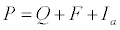
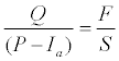
The SCS-CN method assumes that surface runoff will be generated once initial losses are satisfied. The SCS-CN method explaining the water balance can be given by equation 1. The main hypothesis in this method is that the ratio of direct runoff to the rainfall depth minus initial losses (P- Ia) is equal to the cumulative infiltration as given in equation 2 [7].
 (1)
(1)
 (2)
(2)
Where the terms P is total precipitation (mm); Ia is the initial abstraction (mm); F is cumulative infiltration (mm); Q is direct runoff (mm); S is the potential maximum retention or storage capacity of soil (mm). As per USDA-SCS (1985) guidelines the initial abstraction (mm) is assumed to be abstraction fraction (usually λ=0.2) of the potential maximum retention as shown in Equation 3.
 (3)
(3)
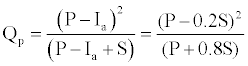
The direct storm runoff Q (mm) can be related to the effective rainfall and actual retention through the water balance equation 4 (Yu 1998). Equation 4 is valid only when Ia = 0.2 Sand generally Ia = 0.2S , hence Equation 4 can be written as
 (4)
(4)
If effective rainfall P ≤ λS , then direct storm runoff Q (mm) is taken as zero
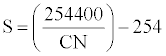
In practice, the potential maximum retention S (mm) of the soil is determined using the curve number (CN) defined by U.S. soil conservation service (1964) given in equation 5.
 (5)
(5)
The term CN is determined from a table based on land use, hydrological soil group, and AMC. The hydrological soil group has four classes A, B, C and D based on infiltration rate of soil. AMC has three classes I, II and III according to rainfall limits for sowing and growing season.
Stream gauge installation
Varekhadi has no discharge measurement gauging station and is classified as un-gauged watershed. This is being a remote location it has been proposed to install automatic sensors with data logger capabilities. WL-16U stream gauge sensors of 25 m cable from Global Water USA were procured and installed in field during June 2010. The sensor has 0.1 mm measurement accuracy, and can record 10 reading per second. Three discharge sites viz. Amli, Visdalia and Godsamba have been selected for installation of stream gauge. The output data has been used for result validation for deferent sub watershed.
The direct storm runoff depends on land use, soil type, and hydrological soil group and curve number. Landsat 7ETM+ data of 10 Nov 2001 has been used for supervised classification of 5-land use classes. A merge product of Landsat7ETM+ band 2, 3, 4 of 30 m cell size with PAN band of 15 m spatial resolution was used for classification. The land use distribution within Varekhadi catchment shows that it is primarily an agriculture catchment as 32% of study area is under agriculture, 46% of area under agriculture and current fellow; 66% of area under wasteland, fellow land and agriculture.
The hydrological soil group within the basin is determined based on physical parameters such as land use pattern and soil properties. The focus of this paper is to predict the quick and practical approach to mapping and analysis of surface runoff with the help of remote sensing & GIS data. The runoff amount depends on some physical parameters such as land use pattern and soil properties. Flooding potential of each sub-watershed was estimated using SCS-CN method. The value of Volume and surface runoff were calculated for extracting percentage flood contribution for each sub-watershed which is shown in Table 2.
| Location | Zankhwaw | Amli | Godsamba | Vishdalia | Wareli |
|---|---|---|---|---|---|
| Area [in km2] | 100.52 | 91.85 | 78.85 | 71.05 | 99.73 |
| Retention S [in mm] | 83.40 | 114.12 | 100.6 | 75.95 | 41.11 |
| Weighted CN [-] | 75.28 | 68.95 | 71.63 | 76.98 | 86.07 |
| Rainfall [mm] | 277.0 | 267.5 | 251.0 | 251 | 252 |
| Runoff [mm] | 197.15 | 166.68 | 160.81 | 178.77 | 201.73 |
Table 2: Estimation of runoff for each watershed (1999-2008).
It was found that sub-watershed wareli is high flooding potential having. It was also observed that sub-watershed Amli is low flooding potential having low percentage of contribution. Flooding potential depends on curve number and curve number is also depends landuse and soil properties of watershed which is clearly reflected in results found out.
It is required to estimate a coefficient that reduces the total rainfall to runoff potential after losses in terms of evaporation, absorption, transpiration and Surface Storage. It can be stated that the higher the CN value leads the higher runoff generation. Wareli watershed has 86.07 weighted CN so that wareli is a high flooding potential watershed and Amli has 68.95 weighted CN so that it gives low run-off. The details run-off depth map has been given below in Figure 6.

Figure 6: Runoff depth map for study area.
Figure 7 suggests that a graph of runoff vs. rainfall data will conform to a simple linear relationship with a good polynomial trend line. The 10 years rainfall data from 1998-2008 run-off has been used to calculate runoff for each sub-watersheds and graphs was drawn. The correlation coefficient R2 values are similar for all 5 sub-watershed.

Figure 7: Rainfall-Runoff modeling for five sub-watersheds; Zankhwaw, Amli, Visdalia, Godsamba and Wareli.
Stream gauge data ware used for result validation (Figure 8) for a common event of 2010 and It is found that model can give a good and more accurate result for ungauged catchment

Figure 8: Result validation of predicted or calculated with stream gauge data.
Conclusion Remote sensing and GIS data are of great use for surface runoff estimation when conventional methods of runoff estimation are inadequate. Both data bases have been used as model input for determination of physical characteristics of watershed such as land use, hydrology soil group and CN number. Gaussian maximum likelihood classifier has been used for classification of land use and shows good field acceptability. It has been integrated with SCS-CN method for identification of watershed, estimation of flood potential for a part of Lower Tapi Basin. The data calculation gives good results for rainfallrunoff modeling. Output results have been validated with stream gauge data and the results are satisfactory. It will be useful for flood forecasting, flood contribution of each watershed and flood discharge measurements. The method may be good tool for runoff estimation for lower Tapi basin and un-gauged catchment like Varekhadi catchment. It can also state that higher the CN value of catchment leads to more runoff and gives highest contribution for flood.
The authors express their sincere thanks to State Water Data Centre officers Mr. MG Golawala, Superintending Engineer and Mr. SG Shah, Deputy Executive Engineer for supplying daily rainfall data of 8-stations in and around study area. We acknowledge assistance rendered by graduate students of Department of Civil Engineering, Nirma University for carrying out field surveys and soil analysis in laboratory.