Journal of Geology & Geophysics
Open Access
ISSN: 2381-8719
ISSN: 2381-8719
Research Article - (2015) Volume 4, Issue 4
The goal of this study is to develop different scenarios of water resource availability in near upstream of Kaligandaki River basin, under climate change-induced parameters such as precipitation and temperatures variability, considering a potential doubling of the atmospheric CO2 concentration in the next 100 years. Climate models suggest that global warming could bring warmer, drier conditions to Nepalese high Mountains due to the large topographical differences of the climate parameters. Although precipitation increases are projected by some models, on the glaciers of the Nepalese high Mountains, a detailed knowledge of mass-balance observation and discharge measurement are considered and the combination of both will be analyzed by means of either Water Balance Model (WatBal) or General Climate Model (GCM) with multi criteria model performance evaluation. To obtain reasonable and ensemble result, the discharge measurements should be taken during the melting season which demonstrates that timing of runoff. In most cases, the Water Balance Model CLIRUN3 was combined with 20 years of basic climate information records (precipitation, potential evapotranspiration and water flow) to simulate monthly river runoff in the river basin. Ultimately the flow of river is part of the watershed while the others belong to forest lands. The model will be calibrated and run for both watersheds under scenarios with temperature increments of +1 and +2°C, while the precipitation changes considered were ±15% for the locality and ±20% for the overall river basin. It was observed that the monthly runoff tends to considerable decrease of the mean value in the watersheds when temperature increases and precipitation decreases. If both temperature and precipitation increase, the mean runoff value in the region will be reduced by considerable amount as 5 to 35% from monsoon to non-monsoon season. In the basin of the locality, this will also cause to potential evaporation. Thus, soil moisture and water availability may decrease over much of Kaligandaki river basin with serious consequences for rained and irrigated agriculture, urban and water supplies, hydropower and ecosystems. However, the assessment of global warming impacts on locality is an uncertain task because the projections of different models vary widely, particularly for precipitation, and because it performs poorly in reproducing the observed climate condition of Kaliganadaki. At the end, this will help to formulate numerical flow line glacier model on high Mountains of Nepal at upstream of Kaligandaki river, also this paper concludes with a brief discussion of some other areas of uncertainty in the hydrological modeling of Kaligandaki River flows and possible alternative, external forcing mechanisms for flows in the next few decades.
Keywords: Precipitation variability; Climate parameters; Evapotranspiration; Reproducing
In the past few decades, global climate change has had a significant impact on the high mountain environment such as: snow, glacier and permafrost are especially sensitive to changes in atmospheric condition because of their proximity to melting conditions. The formation and growth of glacier lakes is a phenomenon closely related to deglaciation. Valley glaciers generally contain supra-glacial ponds. Due to warming climate, these ponds grow bigger and merge. This process is accelerated by rapid retreat of glaciers; the above aspects will strongly favor for climate change pattern. In fact climate warming remains a fairly debated issues in the Himalayas region with its consequences. The higher warming rates (0.03-0.07°C) per year have been observed in the central Himalayas and the whole of the Tibetan Plateau and average temperature increases of 0.025°C per year have been recorded around glaciers in the Dhaulagiri Himal [1]. The nature (rainfall, snowfall), amount (<300 mm/a) and seasonality of precipitation have also been considered resulting in more uncertainty about their evolution and hence their impacts. It has been seen the contribution focus on the impacts that climate change might have a natural hazards such as gulling and mass wasting in the Himalayas. The specificity of the central part of the Northern Himalaya in the Mustang area in central part of the Nepal, the type of hazards increasingly arise from the climate change, and potentially threaten the population and their current efforts to develop infrastructures and new sources of income.
Upper kaligandaki river basin
The upper Kaligandaki River Basin is located in the trans-Himalayan region of Nepal (Figure 1). And is boarded with Tibet Autonomous Region of China to the north, east and west. Himalayas are geologically young, fragile and hit by continuous denudation. Basin covers an area of 3573 square kilometers with the elevation ranging from 2000 m to 8168 m from the sea level. Due to steep slopes and cuts by river gorges, settlements are not dense, arable land is limited. The Lomanthang (Mustang Valley) is the upper part of the basin is likely to arid and the major farming system in the basin is confined to the middle and upper slopes below 3500 meters.
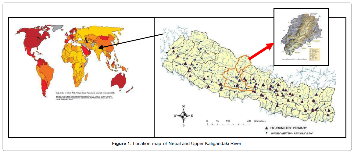
Figure 1: Location map of Nepal and Upper Kaligandaki River.
The Thakkhola Formation, characterized by granite casts and significantly higher amounts of andalusite, indicating source area expansion and erosion of the Mustang-Mugu granites to the northwest; the Upper Pleistocene/Holocene Kaligandaki Formation, bearing higher amounts of epidote/klinozoisite and ophiolite and highpressure/ low temperature detritus as indicated by chrome spinel and blue amphiboles, derived from the north-lying Indus-Tsangpo suture zone [1]. The composition of caustic sediments in general not only depends on the source rock type but also depends on distance and type of transport, size and setting of source region, climate and resulting weathering effects had significantly occurred in the Thakkhola Mustang area.
Climate and vegetation
Kaligandaki River basin lies in the rain shadow area and receives less than 300 millimeters rainfall annually. The climate is generally dry with strong winds and intense sunlight. Area between from 2000 meter to 3000 meter altitude has cold temperate climate which is the wettest part of the district and is dominated by coniferous forest. Alpine climatic zone varies from 3000 m to 4500 m. The area is dominated by shrub, thorny vegetation cover and rich in non-timber forest products. Tundra region ranges above 4500 m and is covered with snow all year round.
The vegetation cover is affected by this northward trend in aridity. Near Marpha, Pinus wallichiana forms dense forests, whereas going further north the vegetation altitudinal belt narrows due to both dryness (downslope) and coldness (upslope). It ranges from an open forest of cedar trees (Cupressus torulosa) in the south to a xerophytic Caragana gerardiana (‘‘porcupine heath’’) steppe with Juniperus indica in the north. The exceptionally harsh environment and dissected topography of Mustang make the geo-ecological conditions of irrigation and the potential natural hazards particularly severe.
Climate change: Annual precipitation and temperature trend
Climate change is one of the hot issues of 21st century. The direct and indirect effects of climate change have been observed in many parts of the world. It is predicted that one degree temperature raise at sea level will correspond to two degree temperature raise in high altitude region like Himalaya (Figure 2). Studies have indicated alarming temperature trends in Nepal which varied roughly between 0.06°C to over 0.08°C. Spatial variation of the annual mean temperature trend analysis showed the increasing trend in almost entire country except on few isolated places. The mean temperature of basin has a rising trend by about 0.02 per year [2]. The average annual rainfalls in the basin and on overall western regions of Nepal have a positive trend. Lower part of the basin which is the wettest part has an increasing trend in annual precipitation with the rate of about 0.70 millimeter per decade. The northern part of the basin which is the lowest precipitation region has been experiencing decreasing trend in snowfall.
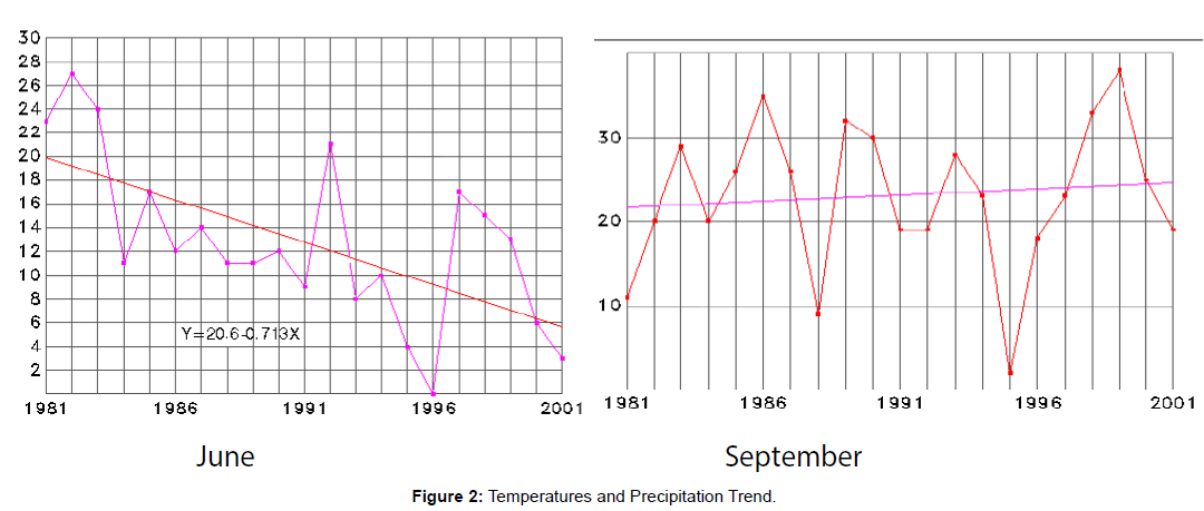
Figure 2: Temperatures and Precipitation Trend.
Precipitation Change Trends of annual as well as seasonal precipitation are presented for different agro-ecological zones and for the whole Gandaki River Basin (GRB) (Table 1). The data sets were analyzed statistically. Annual precipitation showed a decreasing trend for Trans-Himalaya, Mountain and Terai whereas it showed increasing trend for Hill, though none of the trends were statistically significant. The Mountain region shows the largest decreasing trend (−6.293 mm/ year) in annual precipitation. Averaging over the entire basin, monsoon precipitation showed an increasing trend whereas winter, premonsoon, post-monsoon and annual precipitation showed decreasing trends. The decreasing trends in winter and pre-monsoon were found to be statistically significant, the post-monsoon precipitation in Trans- Himalaya, winter and pre-monsoon precipitation in Mountain and winter precipitation in Hill showed significantly decreasing trends. Interestingly, monsoon is the season which shows increasing trend in all the zones, although none of these trends were statistically significant. [3].
The precipitation anomaly maps for different decades were consistent with the winter and post-monsoon precipitation decreasing but the monsoon precipitation increasing, although with changing spatial patterns of anomalies. The post-monsoon precipitation was high in the 1970s and 1980s compared to the 1960s, suggesting that our analysis of the station records beginning in 1981 may miss some longer-term precipitation variability that is not necessarily linear in time.
Snow and glacier melt
There is about 8.46% contribution to annual flow from snow and glacier melt, a maximum monthly contribution of 22.52% in May and a minimum monthly contribution of 1.86% in January in Kosi River in Nepal. The assessment made on Upper Kaligandaki river basin indicated that the snow melt contribution could reach up to 40% (Figure 3) Bhusal and Chapagain [4]. The worst scenarios as per the present projection are that future flow characteristics of snow fed rivers could appear to be like that of present pattern of nonsnow fed rivers., and the reduction in river flows in the basin could be up to 40% if all snow dries up. However, the situation would be more miserable if temporal and spatial variations become wider due to climate changes in future [5].
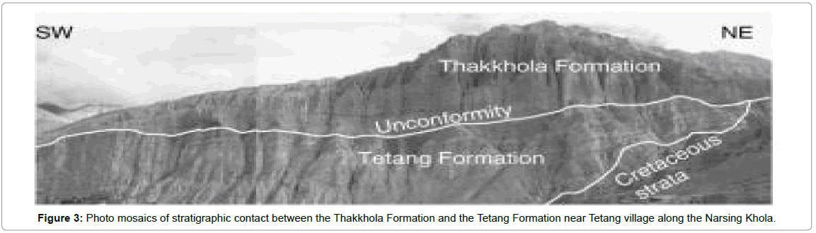
Figure 3: Photo mosaics of stratigraphic contact between the Thakkhola Formation and the Tetang Formation near Tetang village along the Narsing Khola.
The groundwater contribution is also major issues occurred in the particular study. By analyzing 30 years of daily precipitation and discharge within major catchments. The estimated snow and glacier melt contribution to be ~14 Km3/yr (~10% of the annual river discharge, so that groundwater storage in fractured basement constitutes an important compartment of the Himalayan River discharge [6].
The utmost changes in temperature and precipitation in the high mountains of Nepal showed a significant effect on hydrologic processes and the ecosystems. The main objectives of this research were as follows:
1. To estimate the snow and glacier melt from Kaligandaki River basin and to develop adaptive strategies that will help to mitigate the adverse impacts due to climate change on high mountains of Nepal.
2. To determine quantitatively the expected changes on precipitation, evapotranspiration, temperature and runoff due to climate change.
Image processing will be done by using ERDAS IMAGINE or other reliable software. The results from remote sensing (RS) and Geographical Information System (GIS) were applied to link for a Snow melt runoff model. On the basis of studies conducted on glaciers of different parts of world, several models have been developed to assess the responses of glaciers under different climate scenarios, especially from the perspective of melt water [7]. The present study showed comparatively one of the following models such as Degree day model, Energy balance model, which were then used to simulate glacier melt runoff model. By using various parameters such as temperature and precipitation (these parameters will be obtained by Regional Climate Model “RCM”) [8]. The modeled result will be carefully interpreted to gain insight on how the melt water responds with changing climatic elements. The available data sets were also analyzed statistically for getting remarkable decision.
Geological setting
The sediment fill of the Thakkhola-Mustang Graben comprises >870 m of Miocene to Quaternary continental deposits. The graben developed in different successive stages on top of the Tibetan-Tethys sedimentary rocks [9]. The Tetang and Thakkhola formations, of Middle to Upper Miocene age, are disconformably overlain by the Upper Pliocene to Upper Pleistocene Sammargaon and Marpha formations, respectively (Figure 3). The best-estimate of the Tetang Formation age is between ca. 11 and 9.6 Ma, whereas the maximum age of the Thakkhola Formation is 7–8 Ma, based on magnetostratigraphy and C4 vegetation appearance; deposition of Thakkhola Formation continued for at least 2 Ma, and lasted up to the Pliocene. The Upper Pleistocene to Holocene Kaligandaki Formation has a cut-and-fill relation with the older formations and is overlain by modern alluvial gravels.
On the basis of above methodologies and techniques were used and then got desired climate change scenarios. This case study ultimately helped information about the point of recession of snow and glacier melt runoff and adaptive strategies that to mitigate the adverse impacts due to climate change over water resources of Kaligandaki river basin (Figure 4). The basin is highly vulnerable to the changing climate by increasing anthropogenic activities, vehicles and road networks have been deteriorating the local environments further. Preliminary assessments indicated that most of the trapped water sources are going to be dried in future.
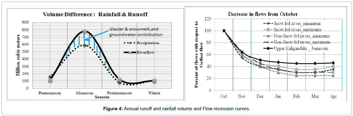
Figure 4: Annual runoff and rainfall volume and Flow recession curves.
Traditionally, villages are agglomerated with maximum care to preserve productive lands. But in the changing context, farmers have a trend to build houses within lands which has been disintegrating the settlements clusters and diminishing productive land systems.