Journal of Geology & Geophysics
Open Access
ISSN: 2381-8719
ISSN: 2381-8719
Research Article - (2015) Volume 4, Issue 1
The main objective of the study is to assess the seismic hazard of different areas of Pakistan in order to ensure earthquake safety of existing and new structures. Try to, describe the Seismicity of Pakistan, carry out Seismic Hazard Assessment of the region and compute Ground Motion of the geographical regions of Pakistan. I have used the PSHA approach of McGuire is adopted to compute the ground motion. Due to collision of Indian plat and Eurasian plate, active faults systems exist in Pakistan. Due to these fault systems, earthquake ground motion analyses are needed to review the Seismic Hazards of the region. For this purpose, GSHAP data is used to map Seismic Hazard of Pakistan. The Scheme of Study follows the Mapping of Seismo-tectonic from Earthquake Catalogue, Earthquake Source delineation Map, and Ground Motion Map from GSHAP data.
Keywords: Ground motion; GSHAP; Seismic hazard
Since creation, the humans are under the influence of natural forces, which have resulted mostly in the benefit of mankind but sometimes nature has induced catastrophes on the societies due to one or the other reason. In natural disasters, earthquakes are the major contributors towards the loss of life as well as the destruction of property. Since the beginning of 21st Century, the increased seismic activity, technological developments and capital intensive civil structures have achieved greater significance on analysis of the structures to determine seismic forces. The dynamic behavior of a structure during an earthquake depends on the earthquake inflicted forces, which are mainly a function of peak ground acceleration. This work will help to mitigate these forces.
The study of the earthquake ground motion associated seismic hazards and risk plays an important role for sustainable development of societies in the earthquake prone areas. Ground Motions are very valuable tools for analyze the performance of structure during the earthquakes. These ground motion may be in the form of seismic hazard maps or design response spectra or their compatible time histories [1].
• In seismological engineering seismic hazard is defined as the predicted level of ground acceleration, which would be exceeded with 10% probability at the site under consideration due to the occurrence of an earthquake anywhere in the region, in the next 50 years. GSHAP has adopted this definition of seismic hazard. GSHAP adopted a computational scheme involving the following steps. Delineation of seismic source zones.
• Characterization of seismic zones.
• Selection of an appropriate ground motion attenuation relation.
We have considered a predictive model of seismic hazard. The GSHAP database is used for the current studies. Whole work consists of preparation of maps from earthquake catalogue, seismo-tectonic map and map for earthquake source delineation, and finally strong seismic ground motion map. The main element for seismic hazard assessment is the designation of the strong ground motion (ground acceleration) by specifying the ground acceleration as a function of earthquake magnitude and hypo-central distance.
Pakistan is located in a geologically active part of the world where the north-west moving Indian plate is colliding with south-eastern part of the Eurasian Plate at a rate of about 1.7 inches per year (43 mm/yr). This collision has created the world’s highest mountains and causes the slip of major faults that generated large, often devastating earthquakes. Examples are the (1) magnitude 7.6 earthquake on Oct 8, 2005 in Kashmir, Pakistan, which caused more than 80,000 fatalities and estimated 5 million people homeless, (2) magnitude 6.4 on Oct 29, 2008 in Quetta, Pakistan which caused more than 10,000 fatalities and estimated 0.5 million people homeless.
Pakistan struck by moderate to strong earthquakes ever year, and struck by a powerful earthquake once in a few decades, causing significant damage and causalities. After Kashmir earthquake, new construction and development require to be designed to accommodate the hazards posed by strong earthquakes. To assist in reconstruction efforts, Centre for Earthquake Studies has developed a preliminary seismic-hazard map of Pakistan using earthquake catalogue of (NEIC) and GHSAP data. The resultant map is detail study of ground shaking in different areas of Pakistan.
Earthquakes are more abundant in and near the northwestern and western parts of country, where the effects of the plate collision between Indian plate and Eurasian plate are most pronounced along MBT (Main Boundary Thrust) and Chaman Faults System. In this region, tectonic forces have resulted in formation of Himalayas, along with frequent moderate to large earthquakes. The map of Earthquakes in Pakistan shows that the frequency and size of earthquakes varies across country and so does the hazard.
Past earthquakes and future possibilities
Future earthquakes are most likely to occur along the plate boundary, which is seismically active area therefore have high seismic hazards. From NEIC, USGS catalog, we tried to determine the location, sizes, frequencies of significant past earthquakes, which are mostly along the plate boundary. Figure 1 is Seismo-tectonic Map of Pakistan, showing occurrence of events of Magnitude range from 5 to 10, most of earthquakes occur along margins of continent plate.
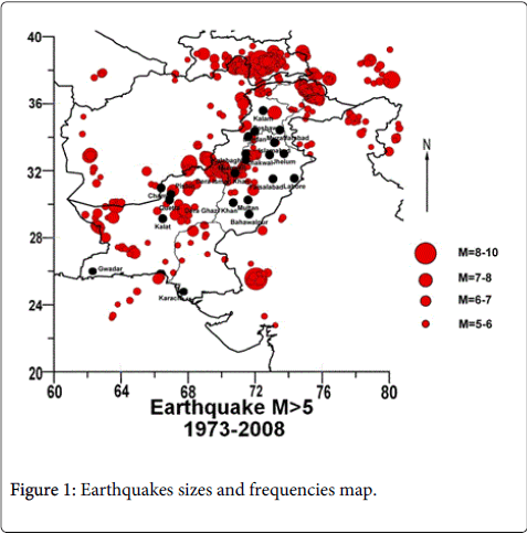
Figure 1: Earthquakes sizes and frequencies map.
The geologic and structural setting of Pakistan
The Study area basically consists of whole Pakistan, which lies between 200N to 400N and 600E to 800E. Indian Plate boundary is characterized by a continental collision along Himalaya in the north and transverse fault system i.e. Chaman faults system in the northwest. Therefore we can say that the continued northward collision of the Indian plate with respect to the Eurasian landmass causes the intense seismicity and has produced the most gigantic topographic feature of the world, the Himalaya. The major tectonic features include Main Boundary Thrust (MBT), the Main Central Thrust (MCT). These features run along Himalayan belt having NW trend. Most of the seismicity in the Himalayan region is concentrated along shallow dipping planes, which indicate underthrusting of the Indian plate beneath the Eurasian plate.
The northwestern Himalayan region also has the characteristic Himalayan tectonic features namely the MBT, MCT and is bordered by the HindukushSyntaxis and the Pamir knot region in the extreme northwest [2]. The Hindukush and the Pamir knot region are characterized by the junction of several tectonic features. This plate boundary region experience high level of seismicity varying from shallow to intermediate-depth earthquakes. Other prominent tectonic features in the north western are the transverse fault systems known as the Chaman fault, the Kirthar and Sulaiman ranges (SR). The tectonic of the Kirthar-Sulaiman ranges is influenced by transcurrent faulting. This region is also belongs to plate boundary and experiences a high level of seismicity. Figure 2 shows main plate boundaries of the study area.
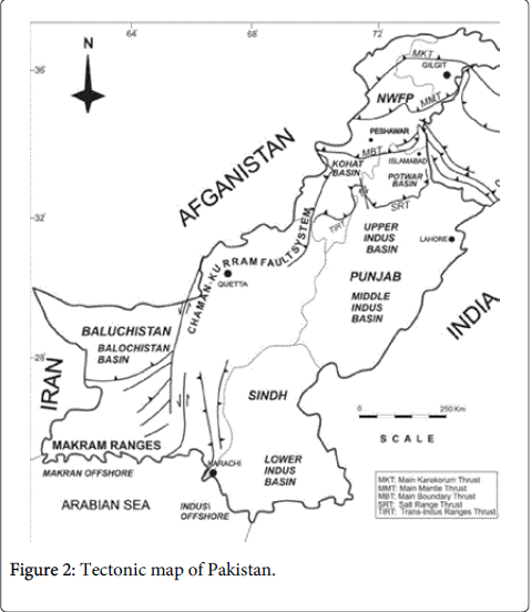
Figure 2: Tectonic map of Pakistan.
To understand the causes of earthquake activity, we must evaluate it in the context of Pakistan geologic and structural trends. For this we studied the structural map Figure 3 shows major faults systems and how they might be related to earthquakes. In this area, there are hundreds of known faults, but most of the faults have not been studied in sufficient detail to determine their current activity and how much they contribute to the seismic hazard.
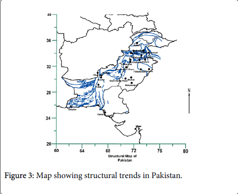
Figure 3: Map showing structural trends in Pakistan.
Studying and mapping possible quaternary faults
Faults that have moved multiple times during the Quaternary Period (the last 1.6 million years) or those that have moved in the Holocene epoch (the last 10,000 years) pose the greatest seismic hazard. The published literature contains no such detailed information on potential and possible activity in faults. The study of previous earthquakes trends, potential seismic zones map, correlating with structural map, we can say that the possibility of seismic activity along MBT and Chaman faults system. But these faults have surface features that are typical of active faults, but for them detailed field studies are needed to confirm the activity and determination of slip rates of these faults.
Seismic hazard analysis
The Calculation of the risk to specific structure from future earthquakes involves the assessment of probabilities of occurrence of the future earthquake (hazard) and the resulting response of the structure due to those earthquakes (response). Seismic Hazard analyses entail the quantitative estimation regarding ground shaking hazards at a specific site. Seismic hazards lead to the development of design ground motion [1].
Peak Ground Accelerations (PGA) is the parameter which is referred to the attenuation characteristics of a region. Earthquake resistant designing of structures and facilities involves the estimation of ground shaking level, which they will experience thereafter. Since the level of shaking is most conviently illustrated by ground motion parameters, thus the methods to estimate the ground motion parameters are utilized. Predictive relationships, which express a particular ground motion parameter in terms of the quantities that affect it most strongly, are used for this purpose. Predictive relationships have a significant role in conducting seismic hazard analyses [1].
The earthquakes records of Pakistan require understanding the level of seismic hazard in along of the country. Many international researchers and institutions have worked on the subject matter. The most notable work was done under the project “Global Seismic Hazard Assessment Program” (GSHAP). The GSHAP embodies many of strategies and priorities of the UN International Decade for Natural Disaster Reduction (UN/IDNDR). Originally in a five year program it was coordinated on a global as well as regional level. It shows the global seismic hazard in the form of Peak Ground Accelerations (PGA) corresponding to a probability of exceedance level of 10% in 50 years (return period of about 475 years). The GSHAP project continued from 1992 to 1999. By using the GSHAP PGA data (peak ground acceleration data), we tried to forecast the probable levels of future ground shaking. The likelihood of this shaking is represented on seismic-hazard map, which shows the probability of exceeding a certain strength of shaking in a 50-year time period. The hazard map shows that the likelihood of strong shaking in the 50 years is highest in northwestern and western part of Pakistan (i.e. MBT and Chaman faults system). Therefore the sever hazard zones are roughly confined to plate boundary region i.e. the Himalayan Frontal Arc in the north, the Chaman fault region in the northwest. As shown in Figures 4 and 5.
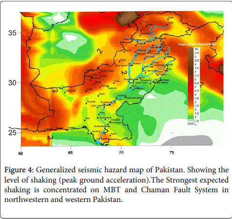
Figure 4: Generalized seismic hazard map of Pakistan. Showing the level of shaking (peak ground acceleration).The Strongest expected shaking is concentrated on MBT and Chaman Fault System in northwestern and western Pakistan.
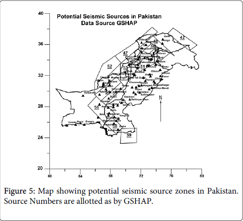
Figure 5: Map showing potential seismic source zones in Pakistan. Source Numbers are allotted as by GSHAP.
Even though the seismic-hazard map is generalized, it provides government officials, engineers and all concern stake holders, information about the location and nature of seismic. The devastating Kashmir (2005) and Quetta (2008), earthquakes shows that social and economic impacts of major earthquakes are catastrophic and can last for decade or more. These maps will allow officials to make informed decisions about the designs and locations of critical structures. This will also allow facilities to be constructed that can better withstand strong earthquakes.