Journal of Geology & Geophysics
Open Access
ISSN: 2381-8719
ISSN: 2381-8719
Research Article - (2015) Volume 4, Issue 5
Detailed palaeocurrent and palaeohydraulic analyses of the fluvio-deltaic Proterozoic Kolhan siliciclastic unit has provided new insights into the sedimentological knowledge of the fan delta deposition, allowing for the reconstruction of paleogeographic and paleoclimatic conditions prevalent in the Chaibasa-Noamundi intracratonic basin of India. The azimuth reading of cross-bed stratifications of fluvial deposits and the preferential grain orientation of different lithofacies have indicated at least two major paleo-flow systems, NW and NE trending. The local occurrence of sedimentary structures of high energy depositional environments has indicated the superimposition of retrogradational strata pertaining to an older progradational fan complex. The fluvio-deltaic Proterozoic sedimentation has followed the emplacement of volcanic dykes, basic in composition, indicating a thermal rejuvenation of the continental crust. Finally, the partial development of limestones and dolomites in the Kolhan succession has pointed out the peneplanation of the cratonic areas and the development of carbonate sedimentation on stable carbonate platform.
Keywords: Paleocurrents; Paleohydraulics; Proterozoic kolhans
Growth of the fluvio-deltaic deposit is driven by the supply of sediment to the basin and the efficacy of its transport and deposition. Together these produce an increase in the elevation of the depositional surface and an overall lengthening of the fluvio-deltaic system. This lengthening is attenuated by tectonic subsidence, which lowers the depositional surface and creates space that must be filled for continued growth. Fluctuations in base level can affect profoundly this balance by influencing the partitioning of sediment between the fluvial plain and the delta, which in turn determines the growth rate of one section relative to the other. A basin’s strata record the complex superposition of these boundary conditions over its lifespan. It is difficult to differentiate the basin-scale stratigraphic indicators when observed at the outcrop scale and thus subject to the bias of human interpretation. Mapping of these features requires the correlation between outcrops, and the certainty of such correlation depends strongly on the frequency of outcrops, which in many locations is limited.
The directional properties from the primary grain orientations (apposition fabrics) and the sedimentary structures are important not only for the reconstruction of paleoenvironment, but also for a better understanding of the basin geometry. Generally the grain orientations represent the paleocurrent direction and the paleoslope at the time of deposition. The dimensions and the type of sedimentary structures are intimately related to the sediment hydraulics as a result of flow variations. Therefore the sedimentary structures are often used as clues to the understanding of the geometries and hydraulics of paleochannels. By analyzing the direction of flow in fluvial paleo-channels and deltaic systems, the sedimentary facies whether upstream or downstream may be predicted. Reconstructions developed using paleocurrent data along with lithofacies are important in exploration for mineral deposits (e.g., gold and tin placer deposits) and in petroleum exploration (e.g., the trend of channel sandstone reservoirs). Such paleogeographic reconstructions are often simplistic and limited to general statements about the direction of flow and probable position of the source area.
Earlier statistical approaches to paleocurrent analysis have concentrated generally on calculation of the mean directions and subsequent analysis of variance [1]. These methods assist in the analysis of the direction of flow, the degree of divergence of flow, and the determination of differences and/or similarities between data sets. Paleocurrent data are used frequently in large scale paleogeographic reconstructions as a means of predicting relative positions of facies belts and basin margin, but only in a semi quantitative way [2]. Lithofacies changes and their characteristics behave as a perceptive depositional environment indicator, which further enhances its utility in understanding ancient sedimentary records.
The Kolhan basin is deposited in the intracratonic basins that developed within the Singhbhum-Orissa and Iron Ore carton and are preserved as isolated outliers namely, Chaibasa-Noamundi basin (study area), Chamakpur-Keonjhar basin, Mankarchua basin and Sarappalli- Kamakhyanagar basin. After the close of the Iron Ore Orogeny, there was a phase of extension. During this phase, the eastern side of the Iron Ore synclinorium was faulted giving rise to a half-graben structure. Within this half-graben, fluvio-deltaic sedimentation took place. The overall style of sedimentation reflects a change from fluvial ephemeral pattern to a delta type. The sediment geometries and the climate exerted a major control on the processes of sediment transfer. Repeated fault controlled uplift of the source followed by subsidence and regression, generated multiple sediment cyclicity that led to the fluvio-deltaic sedimentation pattern.
The sedimentary rocks forming the bulk of the study area are composed of basal conglomerates, sandstones and shales with limestones, unconformably overlying the Singhbhum granitic rocks to the east and the Iron-Ore group to the west. The vertical section commonly shows a fining-upward sequence composed of conglomerates, sandstones and shales, including lenticular patches of limestones from the base to the top (Figure 1a).
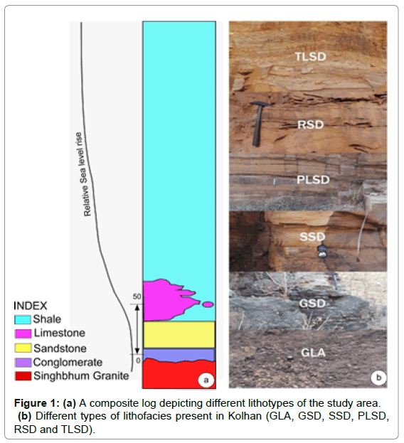
Figure 1: (a) A composite log depicting different lithotypes of the study area. (b) Different types of lithofacies present in Kolhan (GLA, GSD, SSD, PLSD, RSD and TLSD).
In the investigated area both small-scale and large-scale cross-bedding of directional sedimentary structures have been systematically measured in the field. Fabric analysis has been carried out in sedimentological laboratory. Based on standard methods a palaeohydraulic study of different lithofacies has been carried out to determine the hydrodynamic conditions of the Kolhan basin. The different type of lithofacies are (i) granular lag facies (GLA), (ii) granular sandstone facies (GSD), (iii) sheet sandstone facies (SSD), (iv) plane laminated sandstone facies (PLSD), (v) rippled sandstone facies (RSD) and (vi) thinly laminated siltstone-sandstone facies (TLSD). The lithofacies present in Kolhan basin is depicted in Figure 1b. The generalized tectonic map of the Indian continent, including the Purana Basin, the fold and thrust-belts and the cratonic regions is shown for the location of the study area (Figure 2).
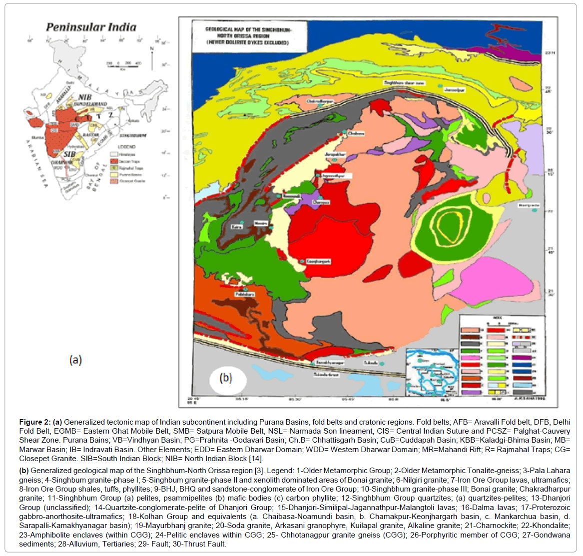
Figure 2: (a) Generalized tectonic map of Indian subcontinent including Purana Basins, fold belts and cratonic regions. Fold belts; AFB= Aravalli Fold belt, DFB, Delhi Fold Belt, EGMB= Eastern Ghat Mobile Belt, SMB= Satpura Mobile Belt, NSL= Narmada Son lineament, CIS= Central Indian Suture and PCSZ= Palghat-Cauvery Shear Zone. Purana Bains; VB=Vindhyan Basin; PG=Prahnita -Godavari Basin; Ch.B= Chhattisgarh Basin; CuB=Cuddapah Basin; KBB=Kaladgi-Bhima Basin; MB= Marwar Basin; IB= Indravati Basin. Other Elements; EDD= Eastern Dharwar Domain; WDD= Western Dharwar Domain; MR=Mahandi Rift; R= Rajmahal Traps; CG= Closepet Granite. SIB=South Indian Block; NIB= North Indian Block [14].
(b) Generalized geological map of the Singhbhum-North Orissa region [3]. Legend: 1-Older Metamorphic Group; 2-Older Metamorphic Tonalite-gneiss; 3-Pala Lahara gneiss; 4-Singhbum granite-phase I; 5-Singhbum granite-phase II and xenolith dominated areas of Bonai granite; 6-Nilgiri granite; 7-Iron Ore Group lavas, ultramafics; 8-Iron Ore Group shales, tuffs, phyllites; 9-BHJ, BHQ and sandstone-conglomerate of Iron Ore Group; 10-Singhbhum granite-phase III; Bonai granite; Chakradharpur granite; 11-Singhbhum Group (a) pelites, psammipelites (b) mafic bodies (c) carbon phyllite; 12-Singhbhum Group quartzites; (a) quartzites-pelites; 13-Dhanjori Group (unclassified); 14-Quartzite-conglomerate-pelite of Dhanjori Group; 15-Dhanjori-Similipal-Jagannathpur-Malangtoli lavas; 16-Dalma lavas; 17-Proterozoic gabbro-anorthosite-ultramafics; 18-Kolhan Group and equivalents (a. Chaibasa-Noamundi basin, b. Chamakpur-Keonjhargarh basin, c. Mankarchua basin, d. Sarapalli-Kamakhyanagar basin); 19-Mayurbhanj granite; 20-Soda granite, Arkasani granophyre, Kuilapal granite, Alkaline granite; 21-Charnockite; 22-Khondalite; 23-Amphibolite enclaves (within CGG); 24-Pelitic enclaves within CGG; 25- Chhotanagpur granite gneiss (CGG); 26-Porphyritic member of CGG; 27-Gondwana sediments; 28-Alluvium, Tertiaries; 29- Fault; 30-Thrust Fault.
The regional distribution of current vectors is shown in Figure 3. It reveals the pattern of transport towards the north-west or northeast in the central region of the area. In the southern region it shows prominent north or northeasterly paleocurrent patterns especially in its lower part. The presence of NNE and NNW paleocurrents, in addition to an important current parallel to the NW has also been indicated. The vector means calculated from grain orientation and cross-bedding indicate at least two distinct flow systems, approximately north-westerly and northeasterly directions during the deposition of the siliciclastics. However the overall polymodal nature of the current rose diagrams suggests interaction of factors during the deposition [3]. The mean directions are almost uniform although magnitude of the vector resultants exhibit frequent variation in the different facies.
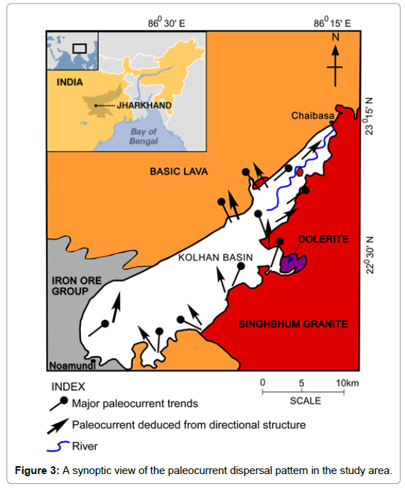
Figure 3: A synoptic view of the paleocurrent dispersal pattern in the study area.
Assessment of the channel morphology and flow characteristics of ancient fluvial system relies heavily on the empirical relationships developed from measurements taken on modern rivers [4,5]. The empirical relationships have been used to estimate average paleochannel morphology and hydrology during the deposition of the Kolhan group rocks [6-9]. At least two input variables are required, the most obvious being channel width and channel depth (bankfull).
The channel width (W), bankful depth (d), width/depth ratio, meander wavelength (lm), flow velocity (v), stream power, mean sediment discharge (Q), Froude number (F) and Reynold’s number (Re) have been calculated following standard methods [6-13]. The empirical relationships used for the present study are.
d=(H/0.086)1/1.19 in m
W=42(d)1.11 in m
lm=10.9(W)1.01 in m
Q=(lm/106.1)1/0.46 in m3/s
v=Q/A in m/s
F=v/√gd
Re=vd?/?
Where, H is average cross-bed set thickness/average ripple height.
A is cross sectional area.
g is acceleration due to gravity.
? is density difference of grain and fluid.
? is viscosity of the fluid.
Reconstruction of bank full depth ranges up to 2.03 m (average about 1.38 m) in sand-bed load streams. It is more difficult to reconstruct channel width because of fewer indicators and because erosional loss of the top of the channel deposit will have a greater effect on the width than depth. The observed average channel width was 61.59 m for sand-bedload channels. The more significant is the relatively consistent relationship of channel width to depth, being 1:43 in sand bed-load channels (r2=0.91). Estimates of average paleohydrologic parameters of the study area have been shown in Table 1. The Froude number (0.2) indicates that the basin is developed in a tranquil flow environment.
| Parameters` | Mean Estimate |
|---|---|
| Mean cross-bed set thickness | 0.13 m |
| Mean water depth (ds) | 1.38 m |
| Channel width (w) | 61.59 m |
| Width/depth ratio (F) | 42.97 |
| Meander wavelength (Lm) | 701.26 m |
| Mean annual discharge (Qm) | 94.34m3/s |
| Channel slope (Sc) | 0.00084 |
| Flow velocity (v) | 0.66m/s |
| Froude number (Fr) | 0.2 |
Table 1: Estimates of Paleohydrologic Parameters of the Study Area.
The source rocks of the Kolhan clastics can be identified by integrating the petrological, sediment dispersal, and provenance data, assuming that there has been no lateral displacement after the Proterozoic Kolhan basin stabilized [14]. This would require that the aerial relationship between sedimentary rocks and their source terrain remained essentially unchanged since early Proterozoic [14].
Both the mineralogical and chemical compositions of the sedimentary and metasedimentary rocks have been frequently used for the determination of provenance. The source rock has been identified from petrographic analysis (Figure 4) and the reasons behind the identification are given.
(a) The presence of pebbles of jasper, white chert, sandstone, banded hematite jasper (BHJ), quartzite, volcanic and granitic rocks embedded in sandy-silty matrix indicates that the sediments have been derived both from the Iron Ore Group and the Singhbhum granite.
(b) Evidence of dual provenance is also inferred from the sediment bimodality, textural and mineralogical maturity, presence of rounded and well sorted grains, and presence of fresh feldspar grains.
(c) The presence of well-rounded grains along with the subrounded and well sorted grains is indicative of sediment maturity and recyclicity. The paucity of feldspar, abundance of fine grained sedimentary lithics, and evidence of sediment diagenesis are indicative of sediment recycling.
(d) The high ratio of the stable (quartz, chert) to unstable grains (feldspar, lithic fragments) indicates a compositional maturity of the sandstones [15].
(e) The presence of clay-rich matrix, frequently replaced by silica and hematite, the reddish and grayish color of the sandstones, low content of feldspar, and presence of chert, sandstone, and granites as lithic fagments are indicative of a dual source (Figure 4).
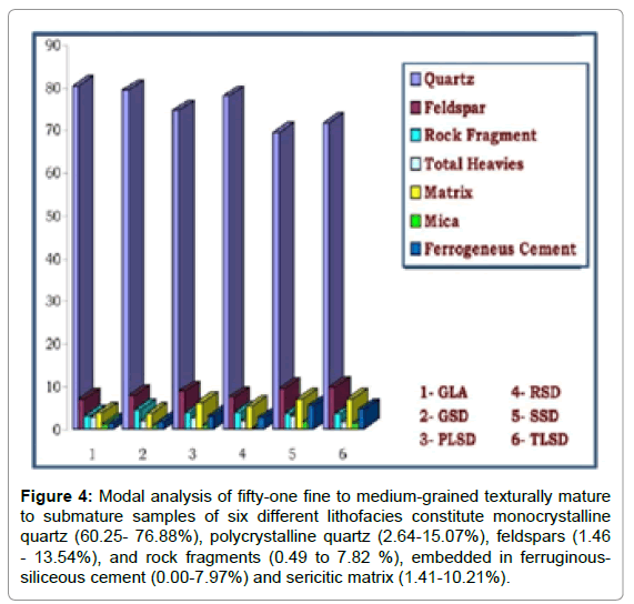
Figure 4: Modal analysis of fifty-one fine to medium-grained texturally mature to submature samples of six different lithofacies constitute monocrystalline quartz (60.25- 76.88%), polycrystalline quartz (2.64-15.07%), feldspars (1.46 - 13.54%), and rock fragments (0.49 to 7.82 %), embedded in ferruginoussiliceous cement (0.00-7.97%) and sericitic matrix (1.41-10.21%).
(f) The climatic condition may be initially humid for the development of subarkose, which later differentiated into quartz arenite [16].
(g) The high ZTR index is consistent with the mineralogical maturity, indicating a depositional complexity, as a result of rapid weathering and upliftment of the source area [17].
(h) The orthogonal nature in the major paleocurrent patterns (NE and NW directions) is indicative of a dual source [18].
This study focuses on the detailed provenance evolution of young, post-orogenic extensional grabens to trace the tectonic history of such late-stage basins. Based on logged sections within the predominantly alluvial to coarse-grained fluvial fill of the graben, the paleocurrent data and the petrology of sandstones and conglomerates including heavy minerals studies were studied to interpret provenance and source areas in detail (Figure 5). Significant changes are recorded by slight differences in heavy mineral and pebble compositions.
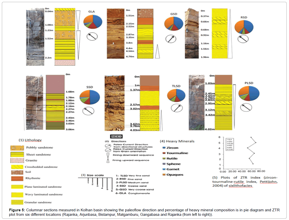
Figure 5: Columnar sections measured in Kolhan basin showing the paleoflow direction and percentage of heavy mineral composition is in pie diagram and ZTR plot from six different locations (Rajanka, Arjunbasa, Bistampur, Matgamburu, Gangabasa and Rajanka (from left to right)).
All paleocurrent data and compositional analyses of clastic rocks of the Kolhans suggest that the clasts were derived mainly from eastern source and also partly from the western margin (Iron Ore Group of rocks).
Heavy mineral analysis indicates that tourmaline, sphene, rutile, zircon, garnet and apatite constitute a significant proportion of the assemblages of all horizons through time whereas epidote, chloritoid, hornblende, chrome-spinel, rutile and amphiboles are less common. These assemblages reflect in general stable minerals and low grade metamorphic source rocks, and are principally controlled by reworking of older, passive margin sediments.
A general northward paleoflow direction brought sediments during the Proterozoic. Heavy mineral associations and pebble composition analyses indicates dual sources. First appearance of granite clasts in the Kolhans reflects the exhumation of basement granites after the deposition of the Kolhans, and is coeval with the appearence of garnet, chlorite within the heavies. High proportion of quartz and plagioclase with alkali feldspar in bulk mineral composition may indicate preexisting sedimentary and granitic source rocks. Fandelta depositional systems of the mainly followed and was dominated by northward paleoflow directions. Although large variations in heavy mineral associations are typical for such fluvial basin fills deposited in post- orogenic extensional grabens, the evolution of heavy minerals in time indicates slight differences marking changes in sources due to tectonism. A change in the sediment source from south to west justifies an expansion due to changing tectonism.
The sedimentary sequences within the Proterozoic basins of India occur in multiple unconformity-bounded sequences, and are characterized by a high degree of commonality with respect to the lithological and lithofacies associations and depositional environments. The sequences are dominated by fluvio-deltaic clastics and carbonates, occurring as facies sheets that extend over thousands of square kilometers and are arranged in an aggradational facies architectural order. These are described as layer-cake stratifications. It is believed that these are intracratonic basins that developed along the crustal weak zones and later rapidly evolved into small and large basins. The depositional systems of the thick wedges and sheets of mature clastics of the Paleoproterozoic Kolhan basin is similar in many respects with the Waterberg Group preserved in the Middelburg basin developed on the Kaapvaal craton, South Africa and Bababudan Group developed on the Dharwar craton, India, suggesting a possible Indo-African connection during the Archean – Proterozoic era.
Detailed analysis of the paleocurrent and paleohydrulic studies with respect to lithofacies and heavy mineral analyses in the Kolhan basin makes possible to interpret its general depositional environment and sedimentation pattern. Sandstone petrography clearly indicates that the basin have Singhbhum Granite in the source rocks. The high iron content in sandstone indicates input from Iron Ore group that also acted as provenance. Grain size parameters shows the sandstones be fine grained and deposited in a fan-delta environment.
Petrography and heavy minerals (high ZTR index) suggests the Kolhan sandstone to be mineralogical matured. Source area and climatic condition shows the sandstone to be deposited in a humid climatic condition. Tectonic condition prevailed during the basin deposition was passive margin basin or intracratonic basin. The studied succession represents the deposits of fan-delta systems, which were built up by sediment gravity flows. The sandy and gravelly gravityflow and stream-flow deposits are usually arranged in coarsening- to fining-upward tectono-depositional intervals. The fining-upward part represents the abandonment phase of the deposition. The interplay of several intrabasinal and extra- basinal controls possibly determined the fluvio-deltaic evolution. A large volume of sediment was then available for erosion in the source area and the fluvial systems began to prograde into the deltaic system. Differences in subsidence rates and sediment supply between different basin compartments are suggested by the distinct evolution of their tectono-depositional intervals.
Paleocurrent study reveals that the low channel sinuous flow that advanced persistently from the north-northeast to a north- northwest direction along a palaeoslope, which remained unchanged throughout the deposition of the Kolhans. The Kolhan basin was filled by fluvial system, which was individually about 61.59 m wide and 1.38 m deep. The river had a low sinuosity developed channels mostly in a north-northwest direction with flow velocity between 0.66 m/s. On the basis of uniformity in the paleocurrent directions, it is inferred that the basin continued north and westward down the paleoslope. The textural and compositional characteristics of the fluvio-deltaic deposits attest to the reworking of a sandstoneand conglomerate-bearing sequence in the source area. Therefore, the overall style of sedimentation suggest a switchover from lowsinuous avulsed channels developed within an overall fluvialephemeral streams to a delta complex under a warm humid climate system. This switchover also accounts for the carbonate platformal dominated sedimentation during the basinal closing phase. Repeated fault-controlled subsidence and subsequent transgression generated multiple sediment cyclicities led to the growth of fluviodeltaic sedimentation pattern.
As a whole, the Kolhan Group is a transgressive feature that is interpreted as having formed in a rift setting that is perhaps related to the fragmentation of the Rodinia supercontinent. The basin architecture, the spatial and temporal constraints, the framework of the basement, the basement heterogeneity, intrusive volcanic dykes and the thermal history have to be examined to develop a coherent geodynamic model for the complete process modeling of the Kolhan basin.
The authors would like to express gratitude to Prof. D. Sengupta, Head of the Department of Geology and Geophysics, IIT Kharagpur for providing research facilities.