Journal of Geology & Geophysics
Open Access
ISSN: 2381-8719
ISSN: 2381-8719
Research Article - (2022)Volume 11, Issue 5
The WON-X field was discovered in the western portion of the Beni Suef Basin in Egypt, which is now being investigated and exploited in the north of Western Desert, Egypt. Within this concession, the WON-X field is built in a way that makes it good at making hydrocarbons. One of the promising areas newly added to Egypt's strategy for future oil exploration is the West Beni Suef basin (WON-X). Interpolated seismic data-oriented NE-SW and passing through well faults, showing the faults that affected the research area, were oriented NE-SW and passed through wells. In an unconformable manner, the Lower Cretaceous, Albian Kharita Formation overlies the basement rocks. The original Nile was at the top of the seismic section, where the sediments were eroded in different ways until they reached Abu Roash E (A/R E) member. As a consequence of multiple drilled wells and the analysis of the well data such as the pressure measurement which were different in the southern and the northern parts of the field, it was possible to identify substantial lateral variations in the reservoir, such as stratigraphic barriers. Through the integration of seismic and geological well data, significant experience and a greater understanding of the Abu Roash (AR "G") reservoir potentiality have been gained in the WON-X oil field. The seismic attributes such as the RMS map may be used to detect the different compartments in the field as well as other geologic parameters whose amplitude response allows them to be isolated from background features. Additionally, the RMS map displays the stratigraphic mud barrier that formed between the wells in the study region. In addition to typical fault lines, the WON-X hydrocarbon oilfield is situated on a double plunging anticline, also known as an "asymmetrical anticline". According to maps of the AR "G" reservoir, the centre of this anticline is an ideal location for oil accumulation.
Reservoir characteristics; Seismic interpretation; A/R (G) reservoir; WON-X field
The area of research WON X is a significant oil field in Egypt's North Western Desert, located between 28° 57' 0" N and 28° 59' 0" N and 30° 53' 0" E and 30° 56' 0" E. The WON X Field is an important oil field in the north of Egyptian Western Desert (Figure 1). It is located east of the Qarun oil field and south of the Gindi basin. The West Beni Suef basin (WON) is one of the most promising places to search for oil and gas in Egypt's Western Desert [1]. It was added to the country's long-term hydrocarbon exploration strategy relatively lately.

Figure 1: Location map of WON X oil field in the Beni Suef basin (modified from Google Earth).
Geologic settings
The stratigraphic review of the northern part of the Western Desert (Beni Suef basin area) shows a sedimentary succession from recent to Pre-Lower Cretaceous and basement (Table 1). It consists of alternating depositional cycles of clastics and carbonates [2,3]. The Upper Cretaceous section is divided into three rock units, which are from bottom to top: Bahariya, Abu Roash and Khoman formations. The Miocene or recent age of the homogeneous "Clastic Deposits (ancestor Nil Valley) They were deposited by the former Nile River and are composed of sand, silt, shale, and reworked limestone. This would have a negative effect on imaging of the seismic data.
| Age | Formation | Lithiology | Source | Reservoir | |||
|---|---|---|---|---|---|---|---|
| Miocene or recent | undifferentiated classic deposits | 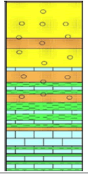 |
 |
 |
|||
| Creataceous | Upper | Camp maest | khoman |  |
|||
| Turonian | Abo Roash | A | |||||
| B |  |
||||||
| C |  |
||||||
| D |  |
||||||
| E |  |
||||||
| Cenomanian | F | ||||||
| G |  |
||||||
| U Bahariya |  |
||||||
| L Bahariya |  |
||||||
 |
|||||||
| Lower | Aldian | Upper kharita |  |
||||
| Lower kharita |  |
||||||
| Pre-cambrian | Basement |  |
|||||
Note: 
Table 1: Stratigraphic column of WON-X field.
The origin of Beni Suef basin is a more obvious explanation for the change in basin orientations during the Jurassic and Cretaceous periods. NE-SW oriented Jurassic basins are related in time and space to the opening of the Neo Tethys Ocean [1,4], whereas WNW-ESE to NW-SE oriented Cretaceous rifts are similar in age and orientation to rift basins in west and central Africa, Sudan, and Libya (Sirt Basin) during the opening of the Atlantic Ocean during Africa's break-up during the Early Cretaceous break [5,6]. With the exception that the basin is controlled by the Aptian/ Albian NE-SW extension movement, Zahran, et al. [7], pointed out that the Beni Suef basin is very similar to that of the northern areas of the Western Desert (Figure 2). As a result of this movement, the Albian Kharita Sediments were deposited directly on the Egyptian Basement Complex's crystalline rocks [8,9].

Figure 2: Simplified tectonic map showing the main basins in the north
Western Desert. Note:  Jurassic fault,
  Cretaceous fault,
  Plateau scarp,
  Cretaceous basin,
  Jurassic basin,
  basement exposures
There are thirty 3D seismic lines (15 cross-lines and 15 in-lines) and a complete set of well logs for five wells available for this study. Regarding the Seismic interpretation, there are two interpretation modules: Horizon interpretation, which is performed on the horizons of interest, and Fault interpretation for the section of interest; these seismic interpretations then are utilized for mapping surfaces. Using Interactive Petrophysics software, determine the petrophysical properties of the Abu Roash G reservoir (shale volume, net pay thickness, porosity, water saturation, and hydrocarbon saturation) and create a separation between shelf mud and intertidal channel for the Abu Roash G reservoir.
As a result of the analysis of the well data, the depositional environment for the upper Abu Roash "G" member reservoir is tidal mixed flat, which means that there is a significant heterogeneity in the reservoir. Therefore, it is a demand to integrate seismic and geological data to determine the changes in the Cretaceous reservoir.
One of the useful tools is the seismic attributes, which aims to extract as much as possible geological information from the seismic data [10]. Root mean square amplitude is one of the most important seismic attributes that could help identifying the lateral continuity hence could refer to the heterogeneity. The RMS attribute is calculated on a sample-by-sample basis without regard of the waveform. It’s a phase of a seismic trace at a selected sample, in degree or radius. This is used to highlight the continuity of weak intra-reservoir reflections.
The study's findings improve reservoir characterization of the AR "G" sandstone facies, aid in the identification of possible hydrocarbon structural traps, and hence aid in regional exploration. Seismic investigation found that the AR "G" reservoir's horizons were chosen to depict the development of structural variables influencing the reservoir. The seismic lines that were available were interpreted to represent an asymmetrical double plunging anticline with a NE-SW axis striking the research region (Figure 3). The double plunging anticline represents the structural control for hydrocarbon buildup in the WON X oil field. The most essential interpretation activity is structural interpretation, which requires constructing maps of multiple horizons as well as a 3D structural model [11]. A large folding event occurred near the northern limits of the Western Desert in the late Cretaceous–early Tertiary period [12].

Figure 3: AR "G" reservoir demonstrates the asymmetrical double plunging anticline that formed the WON X field and the interpreted seismic line.
Well X-9 recorded a pressure of 1900 psi whereas well X-29 recorded a pressure of 2300 psi, indicating the presence of two separate compartments supported by the lateral change of the reservoir sand into mud, as indicated by the well logs data of well X-5. On the other hand, the extracted RMS amplitude map of the reservoir zone showed high RMS values at certain locations where there are faults when compared to the structural map of the ARG reservoir. The RMS amplitude can not only identify the structural elements but also identify any lateral variation in the reservoir such as stratigraphic barriers. There is an anomaly which cannot respond to structural fault but could indicate the contribution of stratigraphy in the reservoir (Figure 4). This can be evaluated by integrating the well and seismic data, as the well data contains a more detailed vertical description of the reservoirs. The integration draws attention to the presence of mud barriers using the well data, but the seismic RMS amplitude map helps in delineating this amplitude away from the wells.

Figure 4: RMS surface slice extracted on top ARG reservoir illustrating the variation in the amplitude resulted from the change in reservoir properties as indicated by black arrows.
Figure 5 shows an instantaneous phase attribute map taken from the ARG reservoir, which shows the reservoir heterogeneity and it structural elements. It indicates the reservoir's continuity as well as the faults that occurred during the Albian kharita formation phase of the rift period. It also displays the stratigraphic mud barrier that formed between the wells in the study field. The RMS results and the net pay map in Figure 6 are in agreement.

Figure 5: Instantaneous phase attribute map on top ARG+50 window illustrates the lateral variation in the reservoir that caused by structural or stratigraphic elements.

Figure 6: Net Sand Isopach Map to integration with seismic data. Note:  Intertidal channel,
  shelf mud,
  ODT@-6416,
  end of data,
  actual data
A three-dimensional representation of the top of the AR "G" reservoir, exhibit the structural relationships between each grid point and the other points on its surface. The highest point in the field is located at the X-5 well, while the lowest points are located on the east and west sides. The interpretation of 3D seismic data helps identifying not only the picture of the subsurface structures, which is an asymmetrical double-plugging anticline with a NE-SW axis, but also draws our intention to the heterogeneity of the reservoir away from the well locations using the seismic attribute analysis.
Normal faults have an impact on the ARG Member in WON the rifting phase in the Late Jurassic and Early Cretaceous in the northern section of the Western Desert created the NE-SW normal faults, which were reactivated in the Late Cretaceous with normal slip in the study area. As a result, we have a strong opportunity to drill further development wells to increase the WON-X' productivity because the reservoir has good properties according to the specifications. The study suggests drilling nine new wells as part of a field development plan based on the current report's results. Drilling water injector wells in WON-X is required to boost reservoir pressure and, as a result, the oil producer wells' production rate.
The authors thank the Egyptian General Petroleum Corporation (EGPC) and QARUN Petroleum Company for permission to publish this study and for providing the data. We thank Schlumberger for furnishing the “Petrel ™” software for the seismic interpretation.
Citation: Kamel I, Abdel-Fattah M, El-Masry M, Shendi E, Ali A (2022) Integrated Seismic and Geological Data to Determine the Cretaceous Reservoir Heterogeneity in the WON-X Oil Field, Beni Suef Basin, Western Desert, Egypt. J Geol Geophys. 11:1031.
Received: 15-Jun-2022, Manuscript No. JGG-22-17347; Editor assigned: 17-Jun-2022, Pre QC No. JGG-22-17347 (PQ); Reviewed: 01-Jul-2022, QC No. JGG-22-17347; Revised: 08-Jul-2022, Manuscript No. JGG-22-17347 (R); Published: 15-Jul-2022 , DOI: 10.35248/2381-8719.22.11.1031
Copyright: © 2022 Kamel I, et al. This is an open-access article distributed under the terms of the Creative Commons Attribution License, which permits unrestricted use, distribution, and reproduction in any medium, provided the original author and source are credited.