Journal of Geology & Geophysics
Open Access
ISSN: 2381-8719
ISSN: 2381-8719
Research Article - (2015) Volume 4, Issue 6
The fluvial river is a kind of open system that can interact with its outside environments and give response to disturbance from outside on the earth. It can adjust itself to the disturbances outside the system and reflects new characteristics in the process of reaching a new equilibrium. The TGD (Three Gorges Dam) constructed at the Yangtze River Upstream was set up to operate in 2003. And it has changed the boundary conditions of the downstream reaches and has broken the long term equilibrium of the Yangtze River system. The reaches alter the river regime to response the disturbance from the TGD. In this paper, the case study Shashi Reach is selected to analyze the variations of the river regime in a river system. The discharge is becoming smoother without large peak or lower discharge for the regulation of the reservoir. The sediment diameter becomes coarser downstream of the TGD and the sediment transport rate decreases as the sediment concentration becomes lower, in spite of the sediment erosion along the reach downstream. The thalweg moves in plane dramatically to adjust itself to reach a new equilibrium. And the topography changes a lot since there are different sediment and flow conditions. The disturbed river system is in the process of reaching a new equilibrium.
Keywords: Yangtze river, Disturbance, River system, River regime, The TGD (Three Gorges Dam)
Rivers are large natural streams flowing in channels on the earth. Generally, river systems are open as other systems in the nature. The river system interacts with its outside environment. The flow, sediments, aquatic animals and plants, and other materials are transported in and out through the river boundaries. The mass and energy do exchange in the river system. River systems always try to be in equilibrium for a long time period, however, the river systems change if there are disturbances at the boundaries imposed by nature and/ or human interventions. A river basin can be seen as an open system and its reaches and tributaries are also types of open systems [1].
The Yangtze River is one of the largest fluvial systems in the world. It is famous for the large water and sediment quantity [2-10]. Shashi Reach is located in the middle Yangtze River and downstream from the Three Gorges Dam (TGD). In the history of Yangtze, the middle Yangtze River, especially Shashi Reach suffered many devastating floods. One of the purposes to construct the TGD is to alleviate and regulate the flood in the middle Yangtze River. However, most of the sediments are blocked in the reservoir after the completion of the construction of the TGD in 2003. The sediment transports through the TGP decrease dramatically and the erosion happen downstream the TGD, i.e., the middle Yangtze River will erode for a long time in order to get the new equilibrium of the river [11,12].
After the completion of the TGD, the Yangtze River System has gone into a period of Post-TGD. The quantities of water and sediment go downstream the TGD become different from that Pre-TGD. Flow regime changes as well as the sediment transports change, consequently also the river regime. Then, as a sub-system of Yangtze River, Shashi Reach system is facing the change of system boundary, i.e., the incoming flow and sediment transport. As a result of the decrease of sediment load, the river bed and bank erodes downstream from the TGD resulting in a change of the river regime along the middle Yangtze River downstream the TGD.
The operations of TGD change the regularities of sediment and flow downstream the TGD. The flow regime and sediment regime change as the operation runs, which give a continuous disturbance to the instantaneous balanced river system. And the sub-system in the river system reflects to the disturbance. One of the reflections is the change of river regime.
This paper describes the disturbance from the construction of the TGD and its influence on the Yangtze River system. The disturbance is analyzed via the comparison of river system boundary between Pre-TGD (before the Three Gorges Dam) and Post-TGD. And Shashi Reach downstream from the TGD is selected to study the river regime responses to the disturbance from the TGD’s operation.
Study area
Shashi Reach from Chenjiawan to Sanbatan Shoal is selected as a case study. It is located about 150 km downstream from the TGD and is about 20 km long [13]. For the operation of the TGD, the upstream incoming flow and sediment transport change a lot with that in the past [14]. This reach can be seen as a river sub-system. The factors in the system change while the boundaries alter for the disturbance upstream.
The river regime has been altering since the impounding water of the TGD. The yearly distribution of water and sediment has changed the downstream river system’s balance. The sediment erosion occurs along the reaches downstream the TGD. Shashi Reach meets serious disturbance from the TGD and the river regime varies every year. The reach is a typical river system suffering disturbance from the TGD. It is very valuable to study the river regime changes in the reach.
Disturbance from the TGD
The TGD was launched to construct in 1994, and it started to impound the water with the operating water level from 139 m to 135 m in June, 2006. Later the TGD started to run with dam water level from 156 m to 144 m in the primary period. The TGD impounded to the water level of 175 m in November, 2010 and started to run in the operation of 175~145~155 m.
After the use of the TGD, the monthly discharges have changed drmatically from that in Pre-TGD (Figure 1). For the TGD’s operation scheme of 175~155~145 m, the water level decreases from 175 m to 155 m in front of the dam from January to May, and reduces to 145 m till June, and keeps still at the water level of 145 m from June to September (the flood season) [15]. The water level increases to 175 m in October after the flood season and is then more or less constant. So the discharge through the TGD alters as the water level changes. The discharge is the same as the incoming discharge from upstream the TGD from May to September in the flood season. Before the flood season, the Post-TGD discharges are larger than Pre-TGD in order to empty the reservoir. Then the reservoir can impound the extra water in the flood season. However, the Post-TGD discharges are less than the Pre-TGD discharges after the flood season. The water quantities are used to generate the electricity. This operation scheme gives a continuous disturbing influence on the whole river system, and the disturbance will push the river regime to change downstream the TGD and have a long term influence.
Discharge regime
According to the operation scheme of the TGD, the discharge downstream will alter due to the change in discharge condition at the TGD site (Figure 1). In Shashi Reach, Shashi Gauge Station reveals the changes in the monthly discharge from 2001 to 2008 (Figure 2). In the dry season from January to May, most of the monthly discharges referred above are larger than the multi-year average discharge. Most of the peak discharges in flood seasons reduce to the level below the multiyear average discharge for the regulation of the TGD. But in 2001, 2002, 2003 and 2005, the peak discharges delayed comparing with multi-year average discharge. After the flood season, the monthly discharges are less than the multi-year average discharge for the impounding water in the TGD.
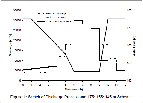
Figure 1: Sketch of Discharge Process and 175~155~145 m Scheme.
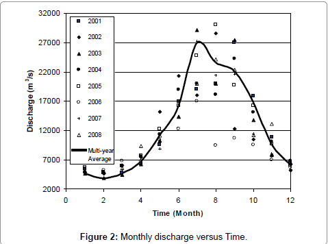
Figure 2: Monthly discharge versus Time.
Generally the discharge regime has been changed in Shashi Reach as a result of the operation of the TGD. The peak flood discharge is reduced below the multi-year average discharge, and the discharges are larger than multi-year average discharge in the non-flood season. The TGD has disturbed the discharge regime in the river system downstream. The disturbance reduces the peak discharges but increase the low discharges. This gives a profound influence on the sediment transport and river evolution.
Sediment regime
The TGD not only impounds the water in the reservoir but also blocks the sediment transport. The sediment transport in the river system was almost in equilibrium statement downstream from the TGD before its operation. However, the disturbance from the TGD broke this equilibrium. The sediment transport capacity is larger than the sediment concentration after the disturbance causing degradation of the river bed of the reaches downstream from the TGD. The sediment becomes coarser since the finer sediment is blocked in the reservoir and the bed load sediment is transported in the flow as suspended sediment.
The suspended load sediment has become coarser and coarser in Shashi Reach since the operation of the TGD, and there is a trend that the sediment diameter will further increase (Figure 3). The percentage of finer sediment will become lower and lower. The percentage of diameter less than 0.01 mm was 60% in 2002. It reduced to 49% in 2004 and reduced to 38% in 2006, to stay approximately 40 in 2008. The medium sediment diameter increased from 0.052 mm in 2002 to 0.099 mm in 2006 with 0.081 mm in 2008 much larger than that in 2002.
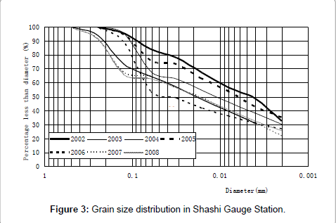
Figure 3: Grain size distribution in Shashi Gauge Station.
The sediment concentration has been decreasing since 2001 (Figure 4). In 2001, the sediment concentration was very high at Shashi Gauge Station, with a peak sediment concentration of 1.35 kg/m3 in the flood season. However, the sediment concentration reduced yearly, not only in peak but also in other situations. The peak sediment concentration is only 0.31 kg/m3, only a quarter of that in 2001. In dry seasons, the sediment concentrations have little differences in the years 2001 to 2008.
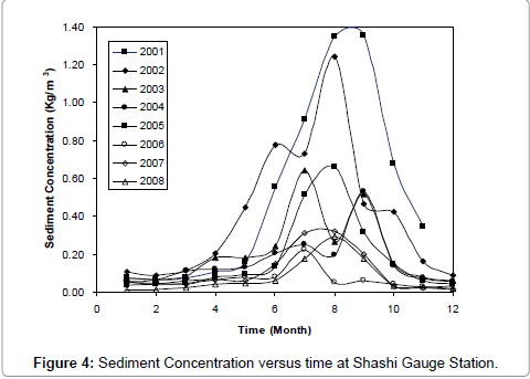
Figure 4: Sediment Concentration versus time at Shashi Gauge Station.
While the sediment concentration decreases, the sediment transport rate becomes lower (Figure 5). Due to the block of the TGD, the sediment can not go through the dam thoroughly. The sediment transport rates from 2001 to 2008 are almost lower than the multiyear average ones. Especially in the flood season, the peak sediment transport rates have been decreased significantly and are still becoming.
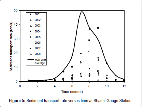
Figure 5: Sediment transport rate versus time at Shashi Gauge Station.
Changes of thalweg and topography
The thalweg reveals the river system’s momentum profile in the longitudinal direction. The change of river topography is a reflection of the response to the disturbance induced by the TGD. The changes of thalweg and topography are shown in Figures 6-10. There are two thalwegs in Shashi Reach. They change almost every year. The right thalweg moves much more dramatically than the left one. Especially the thalweg alters seriously downstream the Sanbatan Shoal. The shoals which move under the flow in the reach are reflected in topography. The change in topography goes on with the development of the shoals. The developments of the shoals are induced by the disturbance outside the river system, i.e., by the variables of incoming sediment and flow downstream from the TGD.
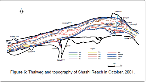
Figure 6: Thalweg and topography of Shashi Reach in October, 2001.
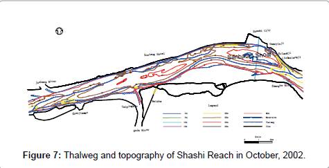
Figure 7: Thalweg and topography of Shashi Reach in October, 2002.
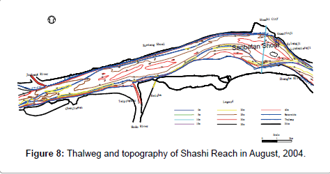
Figure 8: Thalweg and topography of Shashi Reach in October, 2002.
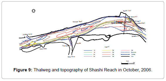
Figure 9: Thalweg and topography of Shashi Reach in October, 2006.
The river system will take a long term to adjust itself to the disturbance and to reache a new equilibrium. If there are changes in disturbance, the system will have to reflect to that and give responses. The changes of thalweg and topography indicate the process of system’s adjustment to the disturbances.
After the operation of Three Gorges Dam, the river regime of Middle Yangtze River has been changing significantly. In the previous research, Zhang et al. [16], Chen et al. [17], Dong et al. [18] and Hu et al. [14] investigated the change of sediment and discharge were affected by the operation of TGD and gave the analysis of these change. Xu et al. [19] studied the Yangtze sediment decline partly from Three Gorges Dam, which mainly focused on the sediment transport change before 2004, however, the TGD had not been completed before 2007. The present study selected the case study period till 2008. Since the launching of the TGD, it has been disturbing the discharge regime in the river system downstream, where the flood discharge reduces but normal discharge increases. The suspended sediment grain size becomes coarser than that in pre-TGD. And the suspended sediment concentration reduces in the yearly distribution, particularly in flood season the suspended sediment concentration reduces dramatically after the operation of TGD. The total sediment transport rate has become lower than those in pre-TGD in yearly distribution. Moreover, the present study analyzed the Middle Yangze River morphological change due to the operation of TGD. And the thalweg changed significantly to adjust itself to reach a new balance in the case study area.
The fluvial river is a kind of open system which can give response to disturbance from outside on the earth. A continuous disturbance gives river system influence and alters the system’s characteristics. The river system has to adjust itself to the disturbance and reflects new river regime characteristics till it reaches a new equilibrium.
The operation of the TGD is a great disturbance to the Yangtze River system not only to the downstream reach but also the upstream reach. The discharge is becoming smoother without large peaks or lower discharges for the regulation of the reservoir. The sediment becomes coarser downstream from the TGD and the sediment transport rate decreases as the sediment concentration becomes lower, in spite of the sediment erosion along the downstream reach. The thalweg moves in plane dramatically to adjust itself to reach a new equilibrium. The topography changes dramatically since there are different sediment and flow conditions. The river system adjusts itself to reach a new equilibrium via the changes of the river regime.