Journal of Geology & Geophysics
Open Access
ISSN: 2381-8719
ISSN: 2381-8719
Review Article - (2017) Volume 6, Issue 1
Pakistan is energy deficient and underdeveloped country but it contains wide resources of low quality coal. The contemporaneous models for Coal Bed Methane (CBM) in low-rank coals have changed dramatically in recent years due to the growth of commercial CBM activity in the Powder River Basin (PRB). The CBM models are still evolving because the CBM evaluation concepts are on steep learning curve based on proven and tested commercial activities. Coal is an unusual lithology in that it is both an excellent source and reservoir rock. CBM resource has also been found in commercial quantities in the Cambay Basin of India. The CBM resource of Cambay Basin and Powder River Basin (PRB) are similar in age and rank to most of Pakistan’s coal. The success in the above mentioned basins provoked geoscientists in Pakistan to re-look into Sindh`s CBM resource. Thar coal is considered as the largest reserves of low ranking coal in Pakistan. Preliminary geological investigation was carried out; results show that low ranked coal seams of class Lignite B to High Volatile B bituminous coal exists in Sindh. The rank specified above is better in quality from Powder River Coal Deposits, so it warrants further evaluation to firm up further exploration and subsequent exploitation. Interactive wireline correlations between several wells have been carried out explicitly. Results show that isolated coal seams of Bara Member (Paleocene) and Sonari Member of Laki Formation (Eocene) exists a few kilometers in sub-surface. The thickness of coal seams is thickest in Thar area with better prospect for gas adsorption capacity. The dedicated CBM studies also reveal that the bituminous coal exists in Badin, Sonda, Thatta and Jherruck areas. Depositional Model of Thar coal deposit has been prepared using plate reconstruction.
Keywords: Coalbed methane, Lower Indus basin, Sindh, Pakistan
CBM is found as trapped and adsorbed on the surface of coal seams found in the subsurface. It is used as fuel gas and is mainly composed of methane (CH4) as its name suggests. Coalbed methane (CBM) is also known as coal seam gas (CSG) in Australia suggesting that there is no unequivocal terminology for gas extracted from coals [1]. Porosity and permeability in coals exists due to the presence of matrix porosity (micropores) and natural fractures known as cleats [2]. According to Ahmad et al. [3], 10% of the world’s coal deposits are present in Sindh, Pakistan, it may be considered promising for CBM potential of the country.
Coal is located in the southern, mid-western and northern parts of Pakistan (Figure 1). Based on geological mapping, coal resources in the south (Sindh) are approximately 185 billion tones and are mostly lignitic to sub-bituminous, while the estimated resources in the north (Potwar Plateau and Salt Range) are 235 MM tones and are Lignitic to Bituminous. Analogy for the coals in the south is Powder River basin (Wyoming and Montana) where extensive CBM operations and production has been taking place.
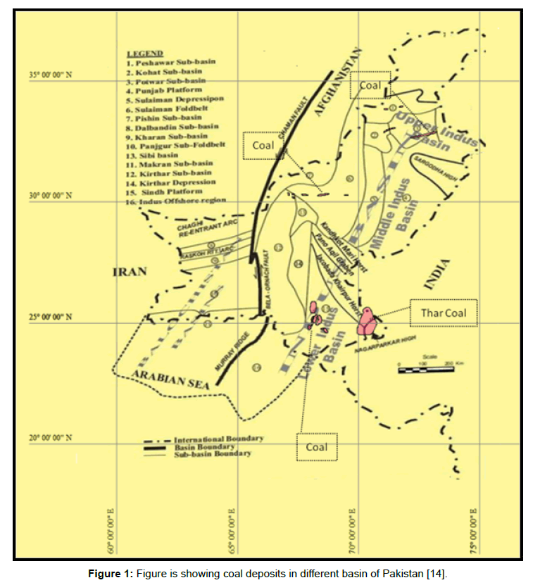
Figure 1: Figure is showing coal deposits in different basin of Pakistan [14].
This study has taken a solid step forward by initiating by evaluating CBM Resources on the basis of available Coal properties. This study shows that coals in the North are much more favorable for CBM due to their maturity and sub-bituminous to bituminous nature.
Previous work
Pakistan is endowed with large reserves of coal deposits ranging from lignite to high volatile bituminous. The 7th largest lignitic coal reserves (Figure 2); need to be exploited for provincial as well as national development. Coal assessment was first initiated by US Geological Survey with the financial help of of US Aid. The largest part of measured deposits is associated with Southern Sindh Monocline [4]. Figures 1 and 2 are explicitly depicting coal deposits of Sindh monocline. Ahmad et al. [3] presented Badin and Thar Coal as potential candidates for CBM and compared coal composition, seam thickness and confined aquifer within and below coal zone with its analog on Indian side. Ahmad et al. [3] proposed strong cooperation among industry and research and development (R & D) organizations/universities in sharing technical information and experience and recommend government support. Siddiqui et al. [2] and Siddiqui et al. [5] presented the results of detailed Scanning Electron Microscopic (SEM) study carried out on coal samples from various locations of Thar and Lakhra coalfields of Sindh to evaluate the porosity and permeability patterns. The study suggested that the Thar and Lakhra coals may have best permeability for the storage of CBM provided other geological factors required for the CBM generation are favorable. Coal deposits in Sindh are present nearby gas pipeline infrastructure (Figure 3). Biggest challenge is to appraise and produce gas at economic rates.
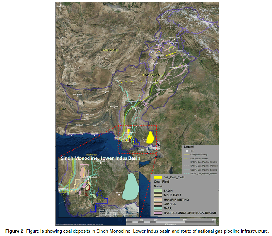
Figure 2: Figure is showing coal deposits in different basin of Pakistan [14].
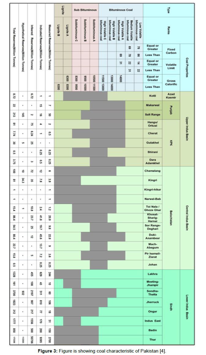
Figure 3: Figure is showing coal characteristic of Pakistan [4].
Malkani [4] presented the details of coal reserves of Pakistan along with coal properties based on various projects carried out by Geological Survey of Pakistan (GSP). CBM potential is evaluated on the basis of data used by Malkani [4]. Operational coal mines aren’t depicting the true coal potential of the country (Figure 4). However, coal reserves measured on the basis of geological mapping adds valuable addition in total reserves. Therefore total reserves of coal are 186 billion tones in Pakistan, out of which most coal is associated with Sindh Monocline. This paper also emphasizes on assessment of CBM resource based on various properties of coal. The coal resources of the major administrative units of Pakistan [4] are as under,
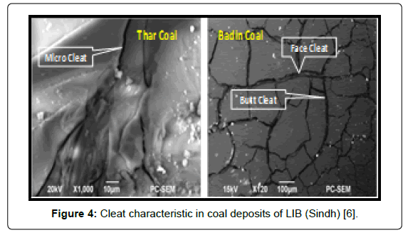
Figure 4: Cleat characteristic in coal deposits of LIB (Sindh) [6].
• Tertiary coal is being exploited from Early Paleocene, Hangu Formation (in Makerwal and Surghar areas) and Late Paleocene, Patala Formation (Central and Eastern Salt Range) in Punjab province. Total reserves of Punjab Coal are about 235 million tons [4].
• Working coal mines in Sindh are Lakhra and Meting-Jhimpir coalfields whilst non-developed coalfields are Sonda-Thatta, Jherruck, Ongar, Indus East, Badin and Thar coalfields with total reserves of about 185,457 million tones [4]. Coal seams are associated with Paleogene rocks of Sindh Monocline.
• Working coal mines in KPK are Hangu/Orakzai, Cherat, Dara Adamkhel and Gulakhel coalfields. Non-developed coal field in the same region is the Shirani coalfield with total reserves of about 122.99 million tones [4].
• The coal deposits of Baluchistan are situated between, Quetta- Duki, it is comprised of commercial deposits over a large area, roughly coincident with the eastern flank of the Sanjawi Arch, and a narrow elongate area between Quetta and Johan. Coal bearing host rock in Baluchistan province is Toi Formation (Eocene). The Eocene coal fields are, Khost-Shahrig- Harnai, Johan,Ghazoe, Ghar, Dewan, Narwel-Dab and Kingri. In the Sor Range near Quetta, the Toi Formation consists of calcareous sandstone, conglomerate, calcareous claystone and carbonaceous shale with commercially exploitable coal seams. Cretaceous or Cretaceous-Tertiary (K-T) coal is present in Maastrichtian age. Total reserves of Baluchistan Coal are about 458.5 million tones.
• Total reserves of Azad Kashmir and Kotli coalfields are about 8.72 million tones (Table 1).
| Coal bearing facies in paleogene of lower Indus Basin (Sindh) Pakistan | |||
|---|---|---|---|
| Early Eocene | Laki Group | Laki limestone | Dominantly limestone |
| Meeting shale | Claystone, sand with bed of limestone and sand | ||
| Meeting limestone | Dominantly limestone | ||
| Sohnari formation | Varicolored lateritic clay and shale with locally coal seams | ||
| Late Paleocene | Ranikot Group | Lakra formation | Limestone, sandstone, shale interbeds |
| Middle Paleocene | Bara formation | Claystone, shale, Early Eocene siltstone, sandstone, coal, carbonaceous | |
| Early Paleocene | Khadro formation | Sandstone, shale | |
Table 1: Coal bearing facies in lower Indus Basin (Sindh).
Cleats in coal deposits of Lower Indus basin (Lib)
Coal contains dual porosity; it contains micropores (matrix) and network of natural fractures, also known as cleats [6].
Analogy of coal fields in lower Indus basin and Powder River basin
The Powder River Basin (PRB) is located in northeastern Wyoming and southern Montana. It covers an area of approximately 66,822.69 square miles with majority of the potentially productive coal zones ranging from about 137 m to over 1981 m below ground surface. Gas Reserves range from 7 to 12 TCF (PPL in-house evaluation). In 2002, wells in the Powder River Basin produced about 823 million cubic feet (Mcf) per day of coalbed methane [7]. Most of the coal in the Powder River Basin is subbituminous in rank, which is indicative of a low level of maturity. Some lignite, lower in rank, has also been identified. The thermal content of the coals found in the Powder River Basin is typically 8,300 British thermal units per pound. Coal is found in the Paleocene, Fort Union Formation and Eocene, Wasatch Formation of Powder River Basin. Most of the Coalbeds in the Wasatch Formation are continuous and thin (six feet or less) although, some localized thicker deposits have also been found.
In Sindh, coal was first discovered from Lakhra in 1853. Most of Sindh’s coal fields are associated with Bara Member of Ranikot Group (Paleocene). However, in some parts, Sohnari Member of Laki Group (Eocene) hosts coal. The thickest coal beds are present in Thar coal field, where maximum thickness is 22.8 m. The average thickness of coal seams range from 0.3 to 2.5 m.
Thar coal field is considered as the 7th largest lignite deposits of world. Thar coal isn’t exclusively Lignite rather it ranks from Lignite to Sub-bituminous-A with heating values (BTU) ranging from 6,244- 11,045 BTU/lb, which is higher than Powder River basin.
The previous Geological and Geophysical (G and G) work is very limited and the true thickness of the seam can’t be concluded from these studies. Preliminary evaluation shows that coal seams distribution is in the form of isolated bodies with chances of thick coal seams in area other than Thar Coal Field. A 6 m thick coal seam is reported in Jheruck coal field and heating value of the seam is 8,800-12,846 BTU/lb which is also higher than Powder River Basin coal (PRB). A brief comparison between coal fields (characteristic) of Lower Indus Basin (LIB), Sindh, Pakistan and Powder River Basin, USA is given in Table 2 and discussed rank wise in Figure 5.
| Composition | Powder River Basin | Lower Indus Basin (Sindh) | |||
|---|---|---|---|---|---|
| Illinois Bituminous | Wyoming Sub-bituminous | Lignite | Sub-bituminous | Bituminous | |
| Heating value (Btu/lb) | 12,770 | 8,683 | 5,219 | 11 | 13,555 |
| Ash (%, dry) | 17.4 | 6.6 | 0.4-4.9 | ||
| Moisture (%) | 3.1 | 23.8 | 9-55.5 | ||
| Sulfur (%, dry) | 4.2 | 0.4 | 0.4-15 | ||
| CaO (%) | 2.7 | 28.3 | NA | ||
| MgO (%) | 1 | 4.5 | NA | ||
Table 2: Analogy between lower Indus Basin, Sindh, Pakistan and Powder River Basin (PRB), USA (Internal reports of PPL).
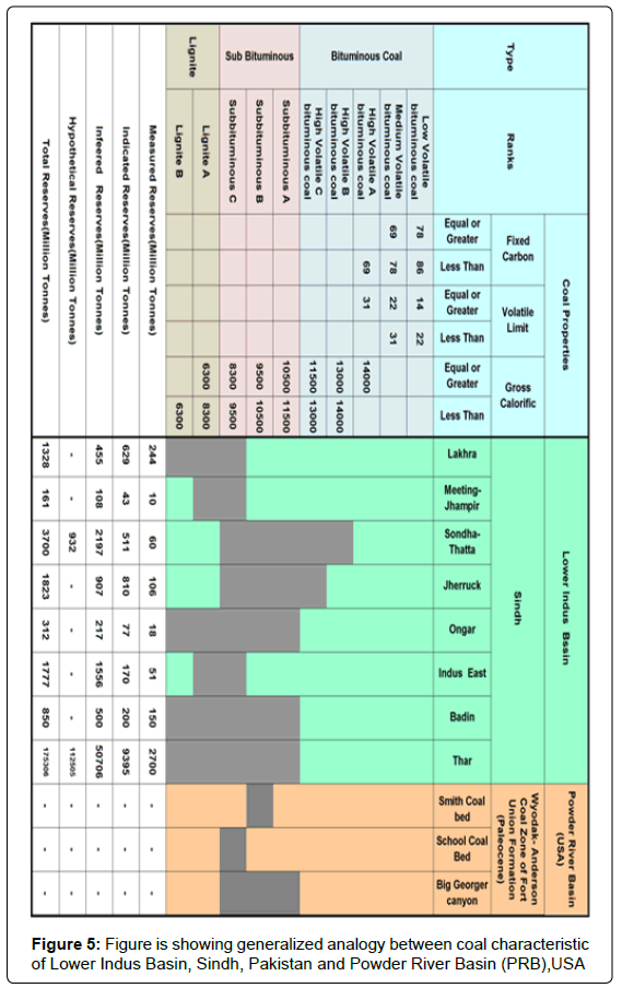
Figure 5: Figure is showing generalized analogy between coal characteristic of Lower Indus Basin, Sindh, Pakistan and Powder River Basin (PRB),USA
CBM resources in Barmer Basin (India)
The Western Rajasthan Shelf which forms an integral part of Indus Basin, and is composed of three main sub basins which are separated from each other by basement ridges/faults. These Sub-basins are:
1. Jaisalmer Sub-basin
2. Bikaner- Nagaur Sub-basin
3. Barmer-Sanchor Sub-basin
Barmer Basin [8] was considered as having extension of coal of Sindh and CBM has been exploited CBM in North Gujrat, nearby Pakistan Border (Figure 6). CBM Exploration in the acreage falling in Barmer-Sanchor Basin, covering an area of about 790 sq. Km in Banaskantha district of North Gujarat was taken up by ONGC as operator [9]. In this area, coal seams are confined to the Middle Tharad Formation of Middle Eocene age (Figure 7). The coal ranks as Lignite and is similar to lignite of Sindh. The Thard Formaton (Lower to Middle Eocene ) is correlatble with Laki Group on the basis of overall lithology and its lower part may considered as extension of Sohnari Member with coal bearing facies in Pakistan but thorough research is needed to firm it up. The initial syn-rift basin fill sediment is of Paleocene age and is equivalent to Syn–rift basin fill sediment of Paleogene in Sindh Monocline.
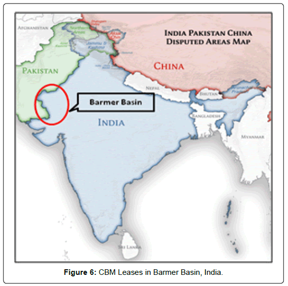
Figure 6: CBM Leases in Barmer Basin, India.
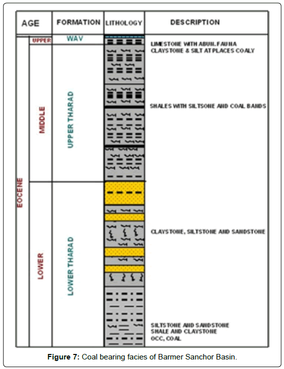
Figure 7: Coal bearing facies of Barmer Sanchor Basin.
According to Rao et al. [10], lab analysis data showed that Barmer Basin coals are high in moisture (9-23%), very low ash (2-9%), content with high volatile matter (30-55%) with low calorific value and were assigned to Lignite rank. Low Vitrinite reflectance (0.28 to 0.4) values were observed, indicating very low thermal maturity. The test wells in the study area did not produce coalbed gas, even after dewatering for one year, showing little accumulation of gas in the drilled wells. This is due to the low rank and low thermal maturity, lack of cleat and fracture, high degree of under saturation, great difference between reservoir pressures and critical desorption pressures. Whereas, Sindh coal is older than Barmer coal, which suggests that it got more time for maturation from Lignite to Bituminous, at places. Interestingly, cleats are present in Sindh coal contrary to Barmer coal, which was the main reason of deterioration of reservoir quality in Barmer coal.
Coal bearing facies in wells drilled in Sindh Monocline
Subsurface data of multiple wells shows that the coal bearing facies are mostly associated with Paleocene (Bara Formation) and Eocene (Sohnari Member of Laki Formation) in the surrounding of the Meeting-Jhimpir and Sonda-Thatta- Jherruck-Ongar areas. Figure 8 is showing thickness of Paleocene coal seams drilled in the petroleum wells situated in the surrounding of Paleocene coal fields of Sindh. Similarly Figure 9 is showing thickness of Eocene coal seams drilled in the wells present in the surrounding of Eocene coal fields (Sindh). Average thickness of Eocene coal is 1-3 m.
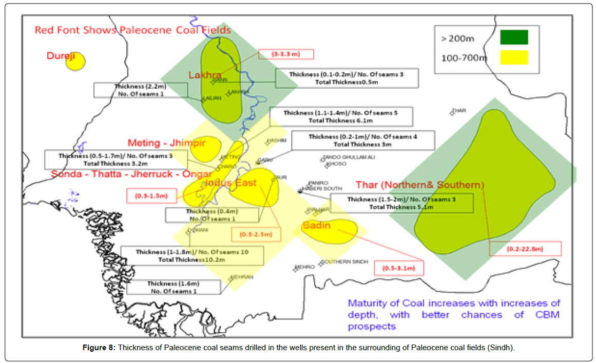
Figure 8: Thickness of Paleocene coal seams drilled in the wells present in the surrounding of Paleocene coal fields (Sindh).
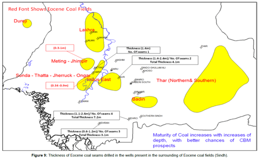
Figure 9: Thickness of Eocene coal seams drilled in the wells present in the surrounding of Eocene coal fields (Sindh).
Quality of Sindh coal
Qualitative analysis of coal bearing facies in Sindh province has been done on the basis of heating values of coal. The data used to arrive on the conclusions was used from the published report of Malkani [4] of Geological Survey of Pakistan (GSP). Lakhra, Meeting-Jhampir and Sonda East are low quality coals, because their rank is restricted to Lignite to subbituminous C only. Best quality of coal is situated in Sonda-Thatta-Jherruck-Ongar areas. Eocene Coal is also present in the surrounding of Sonda-Thatta- Jherruck –Ongar areas. Figure 10 is showing quality of coal seams of Paleocene/Eocene coal fields of Sindh, on the basis of heating values. This heating value is directly proportional to Methane in coal.
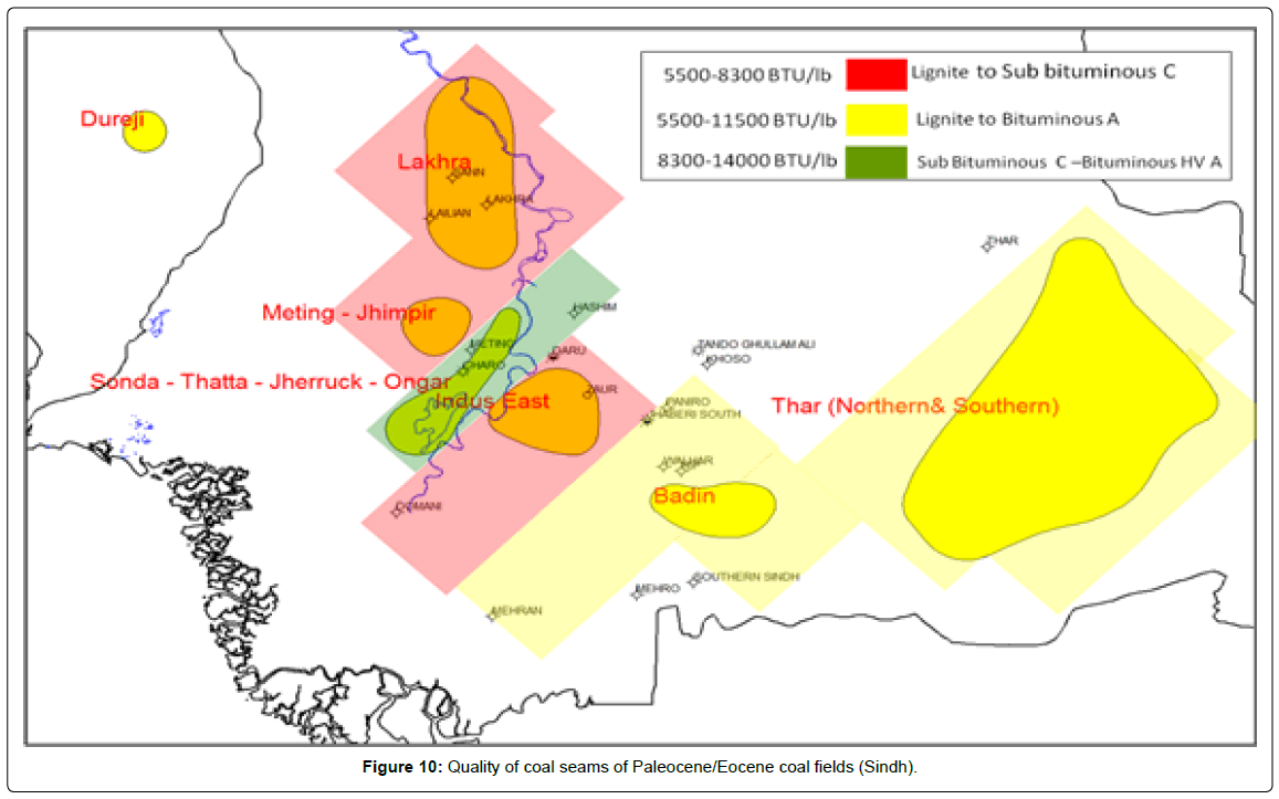
Figure 10: Quality of coal seams of Paleocene/Eocene coal fields (Sindh).
Lakhra and Sodha East contain low ranks of coal, of varying quality. The coal is not lignite throughout, but also matures at places up to Sub Bituminous C, which increases the tendency for adsorption of gas. Similarly, Thar Coal is not only limited to lignite rank throughout, it is also mature up to Bituminous-A rank. Results show that the Thar Coal is the best candidate for the exploration of CBM project as pilot project because (i) Heating value is higher than Powder River Basin and Barmer Basin Coal. (ii) Thickest Coal Seam is present in Thar. (iii) Thar Coal should be extended to deep in basin as deepest is considered, as the best part for exploitation of CBM gas. (iv) Micropores or intrinsic pore spaces within the coal matrix stores the methane gas in Thar Coal [6].
Ash quality of coal of various regions of Pakistan is also analyzed in this paper. Sonda-Thatta-Jherruck – Ongar coals produce highest proportion of ash as compared to other region’s coals. Figure 11 is showing distribution of ash in coal seams of Paleocene/Eocene coal fields (Sindh). Additionally, distribution of sulfur and moisture was also considered and the Figures 12 and 13 are showing distribution of Sulfur and moisture in coal seams of Paleocene/Eocene coal fields (Sindh) respectively. Results show that moisture content is comparatively less in Sonda.
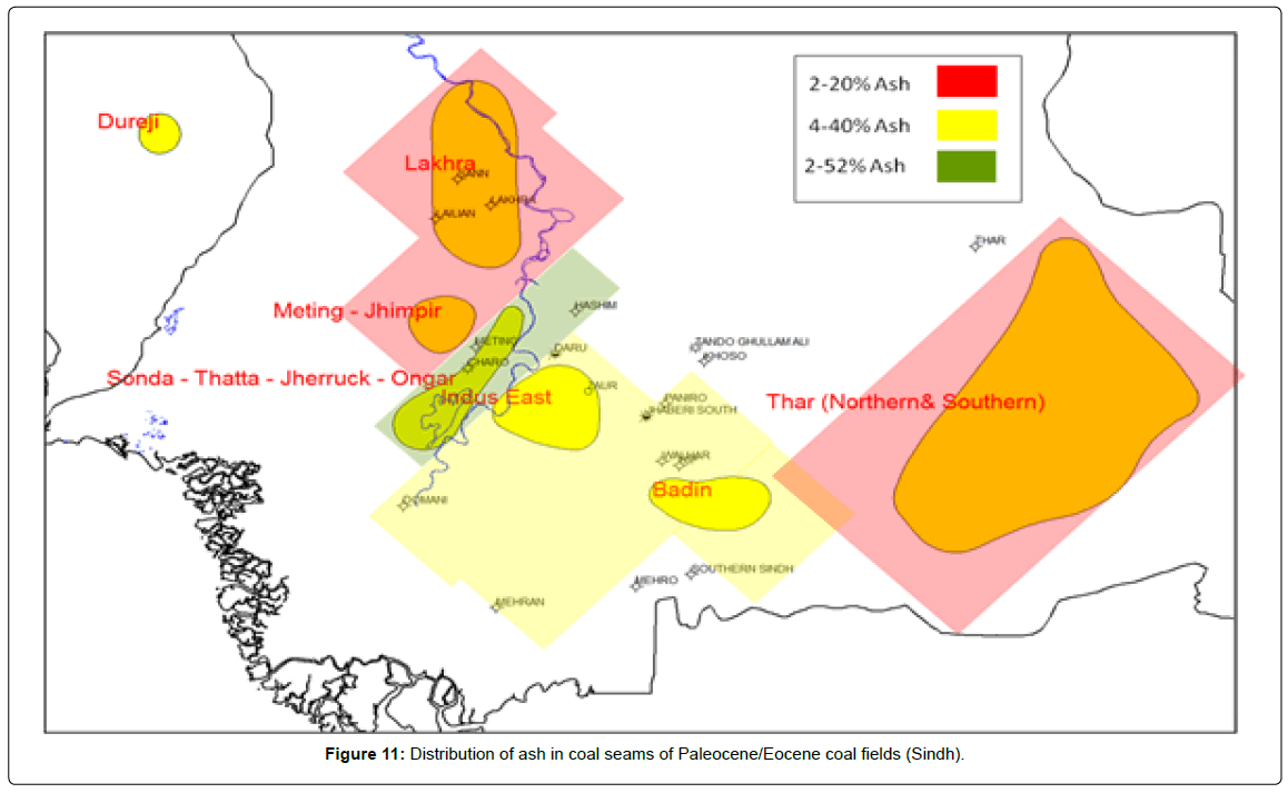
Figure 11: Distribution of ash in coal seams of Paleocene/Eocene coal fields (Sindh).
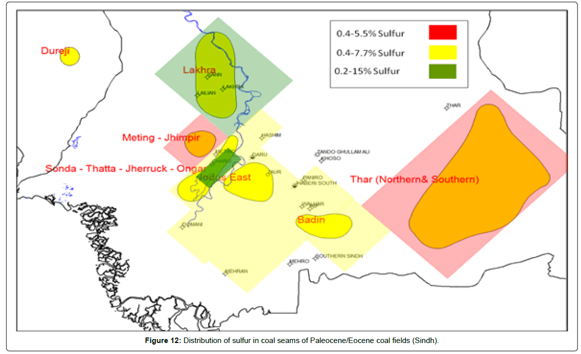
Figure 12: Distribution of sulfur in coal seams of Paleocene/Eocene coal fields (Sindh).
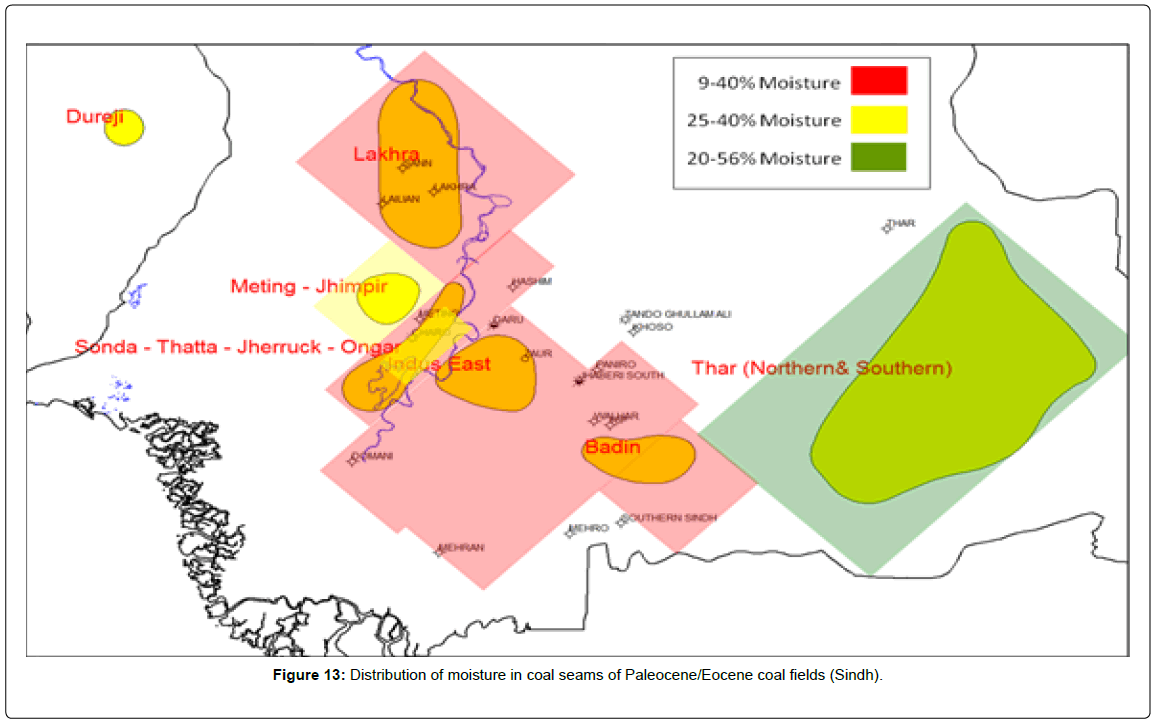
Figure 13: Distribution of moisture in coal seams of Paleocene/Eocene coal fields (Sindh).
Facies study on wireline logs
The depositional model shows that Bara Formation consists of sediments of deltaic environment. The predominant lithology is sand with intercalations of clay and shale (Figure 14). The formation can be divided into two parts,
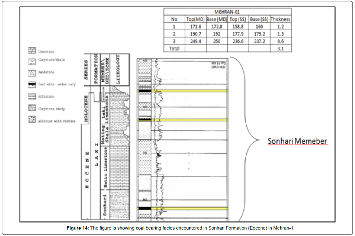
Figure 14: The figure is showing coal bearing facies encountered in Sonhari Formation (Eocene) in Mehran-1.
• Interbeds of sand and shale
• Mostly shaly part with sand at the base
Figure 15 is showing coal bearing facies in the mudlog as well as wireline of Meeting-01 well. The average thickness of coal is 1 m; it can be clearly seen on the mud log and wireline log. The Coal seams as interpreted on wireline log shows that the coals are well isolated seams. Whereas Figure 14 is showing stratigraphic section of coal bearing facies of Laki Group (Sohnari Member).
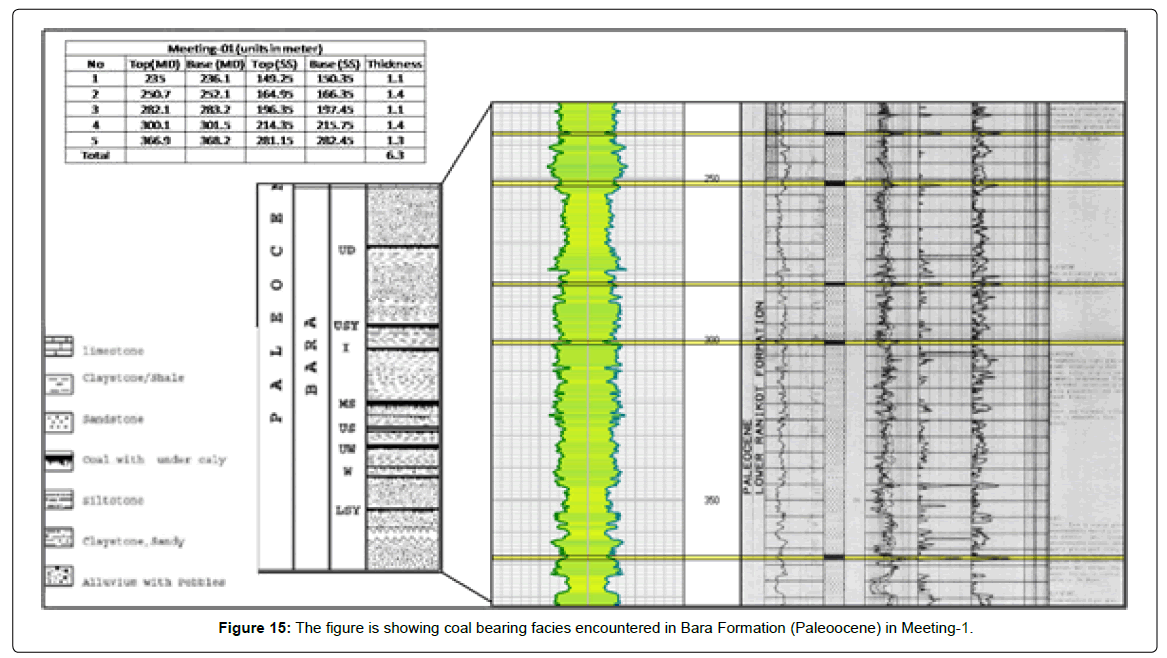
Figure 15: The figure is showing coal bearing facies encountered in Bara Formation (Paleoocene) in Meeting-1.
Eocene coal is present in the SSW of Meeting-Sonda-Thatta- Jherruck Fields. Meeting X-1 is only well in this project which contains both Paleocene and Eocene Coals. Figure 16 is showing wireline correlation of Coal facies in Sonhari Formation (Eocene), Lower Indus Basin, Sindh, Pakistan. Correlations show that isolated coal seams are present and probably deposited along the fringes of river dominant deltaic deposits. Figure 17 is showing Wireline log correlation of Coal Facies in Bara Formation (Paleocene), Lower Indus Basin, Sindh, Pakistan. Three types of facies are identified in wireline correlation.
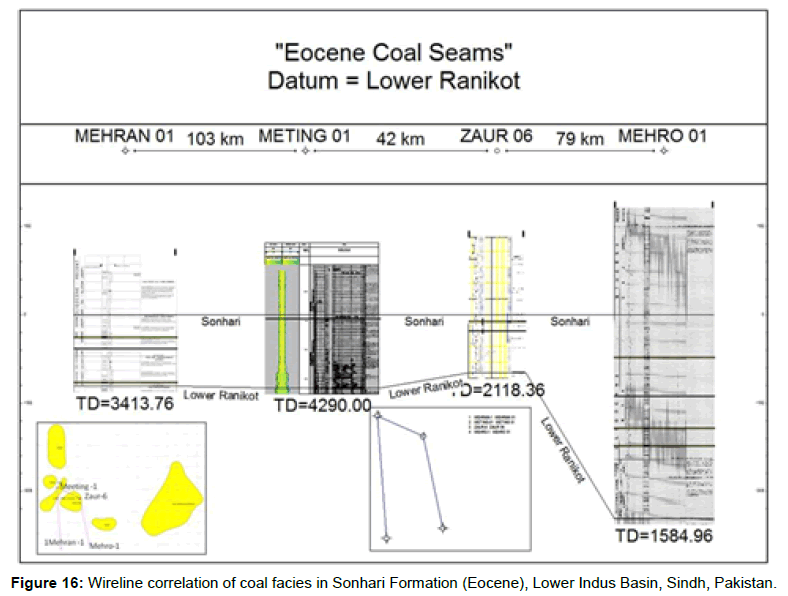
Figure 16: Wireline correlation of coal facies in Sonhari Formation (Eocene), Lower Indus Basin, Sindh, Pakistan.
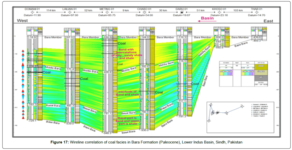
Figure 17: Wireline correlation of coal facies in Bara Formation (Paleocene), Lower Indus Basin, Sindh, Pakistan
Depositional model
According to Malkani [4], Thar coalfield rests on Pre-Cambrian shield rocks and is covered by sand dunes. The coal thickness varies from 0.20-22.81 m. There are maximum 20 coal seams in the area. The most common depth for coal seams is 150-203 m. The thickness of overburden varies from 114-245 m above the top coal seam. Malkani [4] considered Reed as origin of Thar Coal which is commonly used for grass like plant in wetland. The thick coal seam with low ash and sulfur indicate stable upper delta environments [7]. Kumar [11] presented origin of organic matter as mixture of pollens, spores, algae, cuticles, fungi and wood. Kumar’s [11] work suggests that palynological assemblages recommend a warm and exceptionally humid climate.
According to Hakkro [12], Bara Formation (Middle Paleocene) consist of fine-grained sandstone and subordinate amount of shale, carbonaceous shale, siltstone and coal beds of variable thicknesses in boreholes of Thar coal field and investigation of major elements (Si, Ti, Al, Na, Ca, K, Mn, Mg, Fe+3,). The major elemental ratios and their correlation coefficient (r2) show that the origin of its constituting silica content is detrital, which is further confirmed by differences in the source of silica and alumina [13]. Therefore, the studied sediments have potentially deposited along the fringe of basin of deposition in deltaic to near shore depositional environment. They assumed that sedimentation took place under humid climatic conditions, with relatively fast rate of sedimentation, showing better conditions for the growth, accumulation and preservation of organic source material of its coal. They proposed that sediments are potentially derived from igneous and metamorphic rock.
In this paper, Plate Reconstruction was carried out using GPlate software, results show that the greater Indian peninsula was approaching towards line of tropical humid environment (Figure 18) at the time of Paleogene. At that time, Indian Shield element was probably exposed and eroded due to rise and fall of sea and existing humid climatic conditions, as suggested by previous workers. As a result sediments were deposited along Indian Shield Element. As plate moved toward north, mangroves as discussed by Kumar [11] and thick vegetation had been grown in area of Thar Coal Field. Presence of carbonaceous shales show the presence of marshy area, which existed for some time. However, whole area was under influence of humid environment and tidal waves. As a result, thick vegetation grew in Thar Coal field area. Probably, Thar Coal area is relatively high as compare to its surrounding and shows possible reasoning for origin of thick vegetation in limited aerial extension. Figure 19 is showing gross depositional model based on wireline modeling and prevailing literature. Author believes that coal seams are not continuous in wire line logs showing isolated seams in subsurface along monoclonal slope of Sindh Monocline. In Lakhra, Sonda-Thatta, Ongar, Jherruck, and Sondha East, deposition of coal took place along margins of fluvial deltaic tributaries. Vegetation is not thick as compare to Thar in these areas.
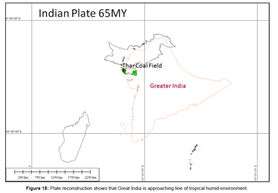
Figure 18: Plate reconstruction shows that Great India is approaching line of tropical humid environment.
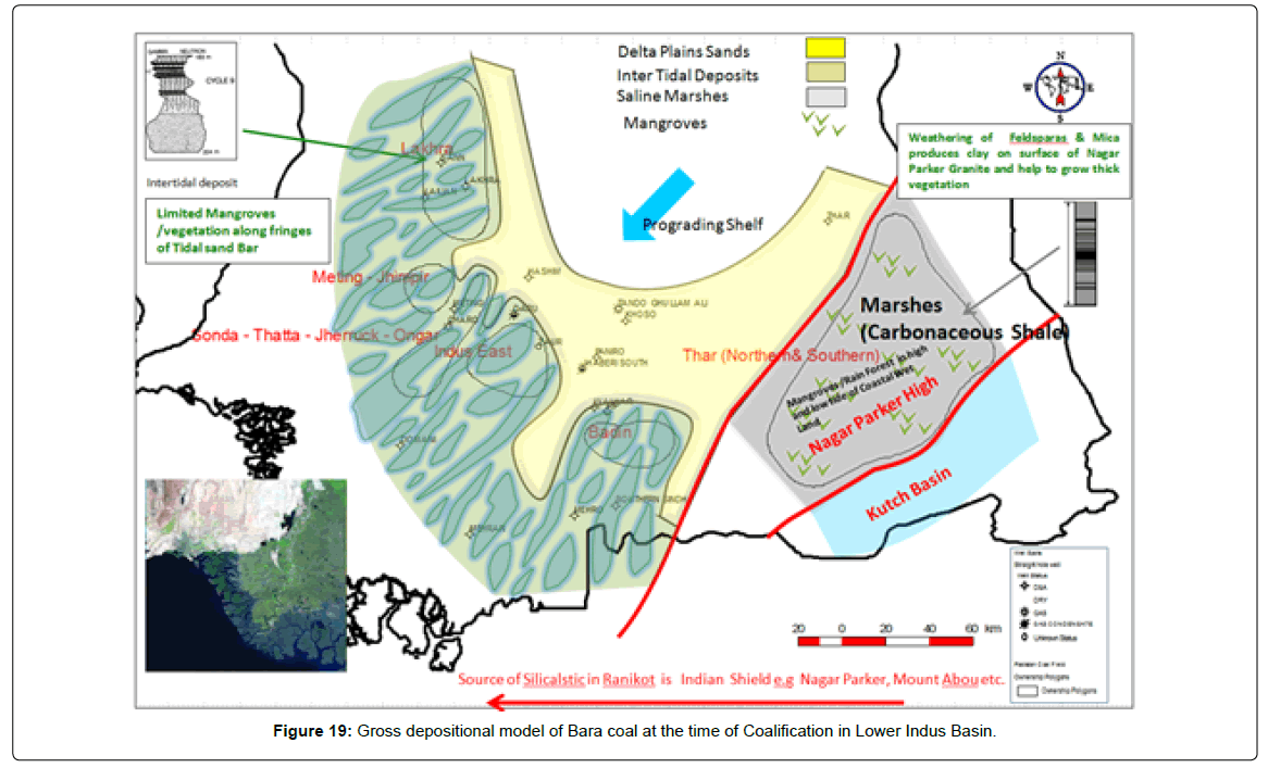
Figure 19: Gross depositional model of Bara coal at the time of Coalification in Lower Indus Basin.
Pore diameter of Thar coal
Professor Dr. Imdad Siddiqui of Sindh University recently studied the characteristics of pores and its effect on probable occurrence of coalbed methane in Thar coal field Pakistan and found that pore; diameter study shows that Thar coalfield has dual porosity. Some coal seams have nearly micropores or meso-pores, while other seams possess meso pores. On the basis of pore’s micropore, the pore volume is also determined and it shows that the pore volume vary between 0.06 and 2.36 cc/g for seams of Thar coalfield. This study shows that the Thar Coal contains pores to harbor free as well as adsorbed gas.
1. Coal is associated with Bara Formation (Middle Paleocene) and Sohnari Member (Early Eocene).
2. Quality of coal has been determined on the basis of heating values, published in literature.
3. Best quality of coal (Sub-bituminous-C, bituminous HV A) is associated with Sonda-Thatta- Jherruck.
4. Ongar, Badin and Thatta coal quality belongs to Lignite to bituminous A.
5. Lakhra-Meeting –Jhampir coal rank is Lignite to Sub-bituminous.
6. Mixed quality of coal is present in all over Lower Indus Basin, Sindh, Pakistan.
7. Coal seams are present in number of wells and could not be correlated to each other; showing isolated seams of coal.
8. Quality of coal will increase with depth along slope of Sindh Monocline. The reason for enhanced coal quality is attributed to overburden and maturation.
9. Thar Coal is considered as the biggest lignite deposits of Pakistan and overall study shows that Thar coal also extends into subsurface along monoclonal slope. Further investigations are also recommended.
10. Presence of cleats in Badin and Thar increases prospectively of coal.
11. Powder River Basin (USA) is considered as analogy of Sindh Coal Fields.
Authors strongly recommend Government of Pakistan, Sindh Coal Authority, National and International Donor Agencies and E&P companies to carry out Pilot project to exploit CBM resources in Lower Indus Basin, Sindh. Gas Pipe Line is already available nearby by prospect area. Seismic Mapping is helpful to mark prospect area for experimental drilling in subsurface. Gas adsorption properties will be established for CBM reserves on the basis of core studies taken during pilot project. We also recommend for development of legal frame work for the exploitation of CBM resources of Pakistan, incentive for exploitation through pilot projects and gas sales agreement as national policy.
We are grateful to the management of Pakistan Petroleum Limited to allow us to publish this paper. We also acknowledge Mr. Salim Muhammad Jandula (GM) and Atta Mohammad Khakwani because present publication is highly appreciated and supported by them. We also acknowledge Mr. Anjum Shah, Senior Geologist, Saif Energy Ltd, Islamabad for providing valuable input during proof read of this article.