Journal of Geology & Geophysics
Open Access
ISSN: 2381-8719
ISSN: 2381-8719
Research Article - (2016) Volume 5, Issue 5
Landslide is frequently occurring natural phenomenon causing land degradation in mountainous region of the world. The fragile Himalayan terrain of Uttarakhand often faces challenging and tough situation due to landslides, particularly in monsoon season. Change in rainfall pattern, anthropogenic activity, deforestation, construction on old landslide debris and Quaternary deposits and displacement of habitation from hill side to valley side are some significant increasing factors for the landslide susceptibility. Anthropogenic activities include very fast, unscientific and uncontrolled urbanization and these are considerably responsible to carved out the disaster viz., landslide, cloudburst and flash flood. Habitation and infrastructure development initiatives in close proximity of streams and rivers as also over Quaternary deposits and unplanned disposal of excavated rock and debris are observed to aggravate the fury of both, landslides and flash floods in the region. Mostly in monsoon season frequent disruption of road network by landslides cause hardship to tourists and pilgrims along with local people. During monsoon season torrential rainfall and cloudburst events are common which acts as basic factor for triggering the landslides in the area. It is therefore necessary to analyse the causes of landslides so as to suggest viable mitigation measures. The paper outlines slope instability and factors responsible for the landslide susceptibility in upper Alaknanda valley, Uttarakhand, India.
Keywords: Landslide, Upper Alaknanda valley, Uttarakhand Himalaya, Triggering factors, Causative factors
Landslides are one of the most common and widespread natural hazards that affect at least 15% of the land area of our country, an area which exceeds 0.49 million km2. Landslides of different types are frequent in geodynamically active domains in the Himalaya. Landslide is an important landform building process promoting soil formation and most habitations in the hills are located in the proximity of old stabilised landslides as these provide suitable land for agricultural operations. Direct losses due to landslides have been increasing and frequent disruption of transport network by landslides has been highlighted as a major hindrance in economic well-being of the region. Present study is an attempt to analyse the causes of landslides in the catchment of upper Alaknanda valley that meets Bhagirathi River at Devprayag to form Ganga River.
The study is initiated with the mapping of landslides in the upper Alaknanda valley and the same is followed by the correlation of these with different natural and man-made feature to assess the influence of these on the occurrence of landslides. This is intended to help in formulating of a viable strategy for minimising the menace of landslides. In the previous some years, mainly due to extreme precipitation events, landslides have however become major cause of concern. Losses due to landslides and flash floods in Uttarakhand in 2010, 2012 and 2013 testify this fact (Table 1).
| Sl. No. | Item | 2010 | 2012 | 2013 |
|---|---|---|---|---|
| 1 | Period of occurrence | August – September 2010 | August – September 2012 | Jun-13 |
| 2 | Number of affected districts | 13 | 2 | 13 |
| 3 | Number of villages affected | 9,162 | 129 | 1,603 |
| 4 | Population affected | 2.9 | 0.08 | 0.5 |
| (in million) | ||||
| 5 | Permanent loss of land (in ha) | 2,35,160 | - | 11,482 |
| 6 | Cropped area affected (in ha) | 5,02,741 | 10,899 | |
| 7 | Damaged houses | 21,045 | 652 | 19,309 |
| 8 | Human lives lost | 214 | 81 | 169 |
| 9 | Human beings missing | 0 | 6 | 4,024 |
| 10 | Persons injured | 227 | 27 | 236 |
| 11 | Animals lost | 1,771 | 537 | 11,091 |
| 12 | Damage to public properties | 3526 | 134 | 2163 |
| (in million US $) |
Table 1: Losses incurred in Uttarakhand due to the disasters of 2010, 2012 and 2013. (Source: Government ofUttarakhand, 2010, 2012, 2013).
The area under investigation lies in the upper Alaknanda valley that falls in lesser and Higher Himalayan terrain of Uttarakhand Himalaya (Figure 1). The study area lies within 78°47’45″E and 80°06’41″E longitudes and 31°05’28″N and 29°55’29″N latitudes. The area lies in seismic Zone - IV and V and receives heavy precipitation during monsoon season. The area is at the same time strategically important and well connected by road network of which National Highway 58 and 109 are an integral part. The area is visited by large number of people every year and the same contributes to the economy of the region. Rudraprayag town is located 140 kilometers from Rishikesh, on Rishikesh - Bardinath National Highway. Rishikesh is the nearest rail head while located in close proximity of Dehradun, the capital of Uttarakhand state, Jolly Grant airport also located in Dehradun.
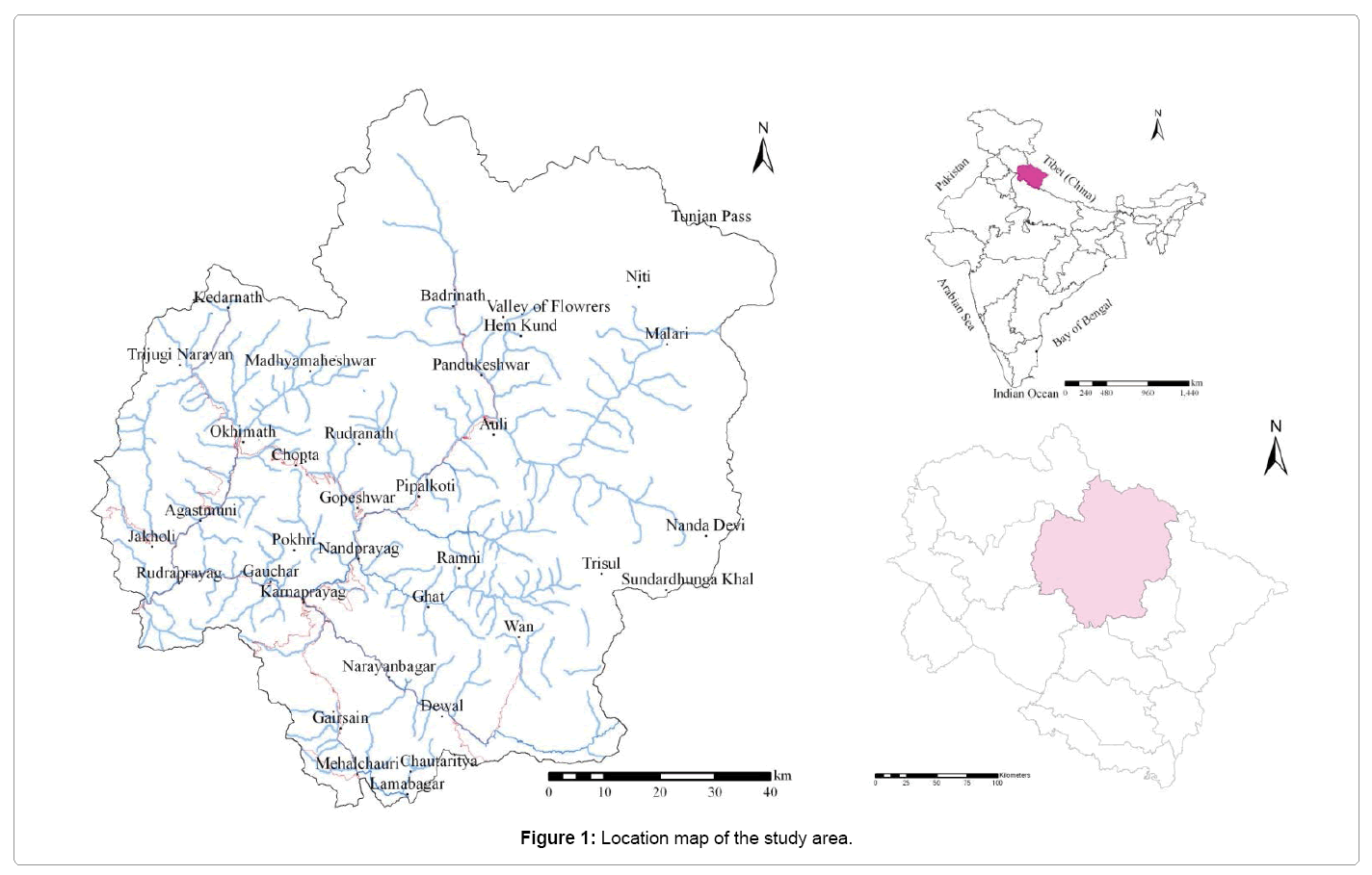
Figure 1: Location map of the study area.
Landslide distribution and classification
The terrain is characterized by predominance of high relative relief; monsoon rains further aggravate the problem of landslides. Various anthropogenic activities for infrastructure development further enhance the susceptibility of slope failure. These factors make the slope in the study area landslide prone. The macro-scale landslide inventory database of the area on 1:50000 scale has been prepared. A number of new landslides were observed to be initiated in the area due to flooding in Alaknanda and tributaries in June 2013. At many places old slides were observed to be reactivated.
A total of 510 landslides have been identified through field investigations in Upper Alaknanda valley (Figure 2). Observed landslides are classified on the basis of movement and rigidity of material comprising the slide mass; bed rock, debris and earth. The summary of the same is given in Table 2.
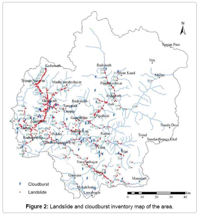
Figure 2: Landslide and cloudburst inventory map of the area.
| Sl. No. | Landslide type | Total number of slides |
|---|---|---|
| 1 | Debris/bouldery debris slide | 346 |
| 2 | Rock cum debris slide | 141 |
| 3 | Rock slide/fall | 23 |
| Total | 510 |
Table 2: Summary of different type of landslides observed in the area.
Landslide triggering factors
Heavy rainfall, bank erosion, road construction, lithological changes, presence of critical structural discontinuity and weathering are deducted to be the main causes of landslides observed in the area. For the assessment of landslide triggering factors proximity of the landslides to roads and streams was particularly analyzed together with other causative factors that include geological and structural set up of the area (Table 3).
| Sl. No. | Triggering factors | Number of landslides |
|---|---|---|
| 1 | Bank erosion | 173 |
| 2 | Bank erosion and change in angle of repose | 74 |
| 3 | Change in angle of repose | 148 |
| 4 | Others | 115 |
| Total | 510 |
Table 3: Summary of landslide triggering factors in the area.
Majority of landslides in this area (33.92%) are observed to be triggered by bank erosion by rivers and tributaries while 29.02% are caused by change in angle of repose, largely for road construction. Another 14.51% is triggered by both bank erosion and change in angle of repose. Large proportion of the landslides (22.55%) is caused by other factors that include heavy rainfall, cloudburst, seismicity, lithological and structural condition of the bed rocks and sub-surface hydrological factors (springs and seepage).
Causative factors
In any area slope, topography and climate play important role for landslide susceptibility. Tectonic movements have resulted in intense shearing, fracturing and faulting of the rocks observed in the area. Some most dominant and considerable causative factors responsible for the landslides are described.
Regional tectonics: It is very important for better understanding of landslide mechanism to study and collect all the data about lithology and tectonics. Stability of a site is therefore often inferred from the geology that is considered a key parameter conditioning landslide occurrence as sensitivity to active geomorphological processes such as landslides is considered to vary with geology [1,2]. Based on the fieldwork done in the area geological set up of the area is reconstructed (Figure 3). While undertaking geological mapping the focus is kept on identifying lithological characteristics of the various rock slopes and landslide zones present in these.
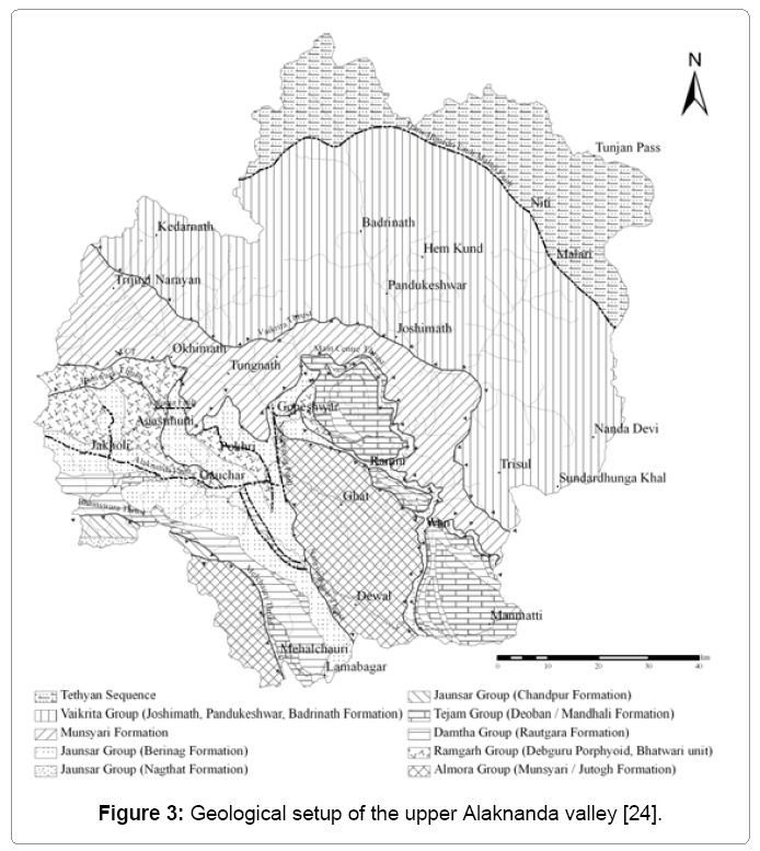
Figure 3: Geological setup of the upper Alaknanda valley [24].
In the study area Central Crystalline rocks are thrust over Garhwal Group of rocks along Main Central Thrust (MCT) which is a northerly dipping major tectonic discontinuity exposed across the Alaknanda River at Helang (Figure 3). The Garhwal Group of rocks of Lesser Himalaya are observed to comprise of low grade metasediments that are intruded by acidic and basic igneous rocks. These consist of thick succession of low grade metasediments made up of quartzite along with penecontemporaneous metabasics and carbonate rocks. The main rocks observed in the area include phyllite, quartzite, limestone, slate, granite and metabasics.
The rocks of Central Crystallines are represented by variants of gneiss, schist, quartzite, crystalline limestone, marble and granite. The lithotectonic succession is given in Table 4.
| Tethyan Sequence | |||
|---|---|---|---|
| -------------------------------------Trans - Himadri Fault / Malari Fault---------------------------- | |||
| Vaikrita Group | Central Crystallines | Badrinath Formation | Calc-silicate with sillimanite-kyanite-garnet-boitite gneiss and schist with granite (associated with migmatites). |
| Pandukeshwer Formation | Biotite and muscovite rich quartzite intercalated with schist and subordinate gneiss. | ||
| Joshimath Formation | Streaky and banded gneiss and kyanite-garnet rich mica schists. | ||
| ------------------------Vaikrita Thrust----------------------- | |||
| MCT zone | Helang/Munsiari Formation | Mylonitised porphyritic granites with subordinate amphibolite, chlorite-sericite schist and limestone. | |
| ------------------------------------------Main Central Thrust / Munsiari Thrust------------------------ | |||
| Lesser Himalaya | Garhwal Group (Metasedimentary rocks) | ||
Table 4: Litho-tectonic succession of upper Alaknanda valley [24].
Main central thrust is major structural discontinuity of Himalaya that traverses through central portion of the study area in northwest to southeast direction. Besides this, there also exist a number of local or regional weak planes. Rock mass in the vicinity of these is structurally weak and therefore these zones are identified as being highly vulnerable to mass wastage. Saturated debris together with fractured, jointed and sheared rocks on the hill slopes are easily displaced by moving water and gravity keeps them moving down.
Geomorphology: The area represents rugged topography characterized by high peaks, cliffs, moderate to steep slopes, elongated ridges, deep and narrow valleys of lesser and Higher Himalaya. The topography is highly precipitous, consisting of series of peaks like Neelkanth (6,596 m), Nanda Devi (7,816 m), Kamet (7,756 m), Mana peak (7,272 m), Sumeru Parvat (6,350 m) and Kedarnath (6,940 m). The slopes of these peaks are covered with snow and glaciers.
The upper Alaknanda valley is highly prone to landslides; particularly area falls in Higher Himalayan crystallines, debris avalanche, debris fall and debris flow are common due to abundantly present overburden material by the glacial and glacio-fluvial action with steep gradient. The prominent glacial landforms present mostly up to Hanumanchatti and Rambara are moraines, cirque, glacial horns, glacial cones/fans, U-shaped glacial valleys, waterfalls and hanging valleys indicated a major phase of glacial activity in the area during Pleistocene period.
Downstream to Hanumanchatti and Rambara V-shaped valleys, river terraces, point bars, sand bars, narrow deep gorges, ‘U’, ‘V’ and ‘S’ shaped sinuosity or meandering have been observed in the area. The landforms present in the study area may be classified into glacial, glacio-fluvial, fluvial and denudational. The Quaternary deposits are present in the form of glacial cones/fans, moraines, alluvium, colluvium and fluvial terraces made up of river borne material (RBM) all along the valley.
The river and stream course of the area appears to be controlled by lithological and structural factors as well as climatic fluctuation. Landscape changes have been enhanced serious problem of slope instability in the region. Gentle and moderate slope have been transformed into steep/vertical slope due to several natural and manmade reason. Unconsolidated Quaternary deposits with less cohesion are highly susceptible to erosion. There exists high probability of slope instability being initiated in these deposits. Hitherto stable slopes were observed to have become unstable due to flooding in the streams.
Heavy rainfall/cloudburst: Change in rainfall pattern has been observed in recent years, rainfall intensity is increasing in place of rainfall amount. The study area experiences enough rainfall due to southwest monsoon during June to September. The precipitation mainly arises during these months. The scattered rains and snowfall arise during winter months. The heavy seasonal downpour on the geologically and structurally deformed rocks creates a variety of slope failures. The rainfall data of the study area was collected and summarized in Figure 4.
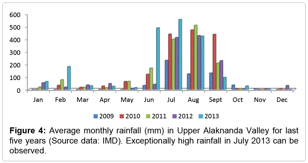
Figure 4: Average monthly rainfall (mm) in Upper Alaknanda Valley for last five years (Source data: IMD). Exceptionally high rainfall in July 2013 can be observed.
It is evident from Figure 4 that the rainfall in the area is highly variable due to its orographic and geographic disposition. The rainfall data reflect that the area has been recorded average maximum monthly rainfall 555.3 mm in July 2013 and minimum rainfall 1.5 mm in Nov. 2010 besides this 0% rainfall also recorded in some months. The maximum annual rainfall is about 1912.20 mm in the year of 2013 followed by 1628.80 mm in 2010 and minimum 562.70 mm in the year of 2009. Exceptionally high rainfall in June 2013 can also observe during five years (Figure 4).
During August and September 2010, Uttarakhand Himalaya witnessed large scale slope destabilization, particularly along the roads where widening work was in progress. The landslides killed about 220 people in the entire rainy season of 2010 [3]. According to National Remote Sensing Centre, ISRO, in the preliminary assessment, a total of 1356 landslides have been identified along the river valley of Alaknanda after Kedarnath disaster of June 2013. On the basis of landslide incidences, inundation and last five years rainfall data the triggering factor for the slope instability is exceptionally high rainfall in the area during the year of 2010 and 2013. The strength of the Indian monsoon determines the intensity of precipitation events in the Himalaya.
Changes in the intensity of the southwest monsoon, during years of strengthened atmospheric circulation correspond to an increase in the number of large landslides (>0.5 km3) in the Late Pleistocene and Holocene periods [4,5].
Moreover, cloudburst is one of the most considerable factors responsible for the slope instability. Such events are related to extreme hydrometrological conditions, debris flow, mud flow and landslides along the tributaries/rivers are common due to this. Torrential rainfall/ cloudburst are the natural phenomenon occurs during monsoon season over the regions dominated by orography like Himalaya. High intensity rainfall of more than 100 mm/hour within a limited geographical area of a few square kilometres is defined as cloudburst [6]. In this area total 52 cloudbursts location were identified and studied (Figure 2).
Based on field observation and information collected from local people mostly seasonal channel have been mostly inundated and debris flow also occurred along these, subsequently debris laden water accelerate the erosion capacity of major river (Figure 5). Slope failures and bank erosion are common during this phenomenon which result sedimentation and sometimes block the river course, turn them into big lake and create flood condition. For instance, the 1970, Alaknanda flood were caused on the destruction of a lake at Birahi, a tributary of Alaknanda [7]. Whereas, the 1978 Bhagirathi floods were the result of the breaking of the lake of Kandolia gad, a tributary of Bhagirathi [8]. Both these incidences have been associated with cloudburst induced landslide dammed lakes. Whereas, landslides in Ukhimath, dist. Rudraprayag and La-Jehkhla landslide dist. Pithoragad are recent example of cloudburst induced landslides in Uttarakhand. In Ukhimath hundreds of landslide scars riddled the ~5 km stretch between north of Chuni-Mangoli and up to Kimana village [9]. On 8th August, 2009 Lah- Jhekla landslide occurred due to cloudburst, the landslide wiped out two villages namely Jhakhla and Lah, claiming 43 lives [10,11].
If bed rocks present debris flow would be less, on the other hand unconsolidated material, old landslide debris, structurally weak area (traversed by fault/thrust and composed by highly weathered and jointed rocks) has been destroyed and damaged in a large scale (Figure 5). Downslope movement of debris was the main cause of devastation in all the previous cloudburst incidences in Mandakini valley that include Bheti-Paundar (August, 1998), Phata (July, 2001), Okhimath (September, 2012). Same was the case in Khirao Ganga (June, 2013) and Bhundar Ganga (June, 2013) in Alaknanda valley. It is noteworthy here that all these major cloudburst induced landslide incidences are concentrated in the Central crystalline domain or up to Main central thrust in upper Alaknanda valley.
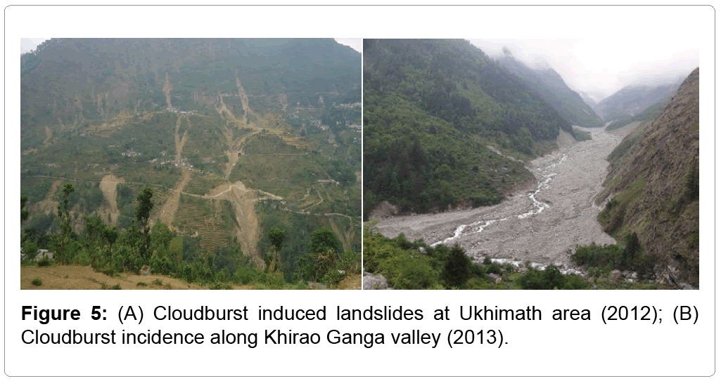
Figure 5: (A) Cloudburst induced landslides at Ukhimath area (2012); (B) Cloudburst incidence along Khirao Ganga valley (2013).
Anthropogenic activities and increase in head load: Several anthropogenic factors are also responsible for making this area conduceive for mass movements. Encroachment into stream and river banks, steep cutting of slopes and left untreated, indiscriminate and unscientific construction of buildings, roads and dams are important anthropogenic activities. During the road construction, the removal of base support destablised the slope and promotes extensive landslides [12]. Newly constructed roads in Himalaya are ravaged by landslides and other processes of mass movements during the rains, thus producing collossal volume of debris [13]. Whereas, during construction phase of Hydro Electric Projects (HEPs) slope failure occur through excavation of slope mass in the construction of roads, tunnel and other project appurtenances. During field investigation a number of landslides were observed around Singroli - Bhatwari, Kali Ganga Stage – I and Son HEPs in Mandakini valley. Blasting with dynamite recklessly for the construction of dams and tunnels has triggered thousands of landslides. When the first rain comes, these landslides fill the riverbed with rubble [14]. Considering the extent of human interference, it is likely that the terrain sustainability is precariously balanced. A minor perturbation would have been enough to generate a cascading effect on the terrain instability. And the impetus was given by the unusual rain during 16 and 17 June 2013, which caused the Himalaya to respond violently against the unscientific human interference [15].
Semi village is situated just opposite to Okhimath town; it was faced worst condition of slope instability. National Highway (NH-109) going through lower, middle and upper part of the village, it was damaged and subsided at several portions (Figure 6). Large scale construction viz., buildings, hotels, shops, petrol pump and road were constructed on the Quaternary deposits. Singoli-Bhatwari hydro-electric project has also been constructed near the village and muck dumping sight was situated just below the village right bank of the Mandakini River. Moreover, absence of adequate drainage arrangement was also observed which exacerbates pore water pressure during heavy rainfall and resulting into failure of the slope. A number of buildings were observed to be damaged and large number of cracks was developed in many buildings. Overloading or increase in head load accompanied with bank erosion induced slope instability at Semi village and several locations in the area. Gaurikund, G.I.C. Tilaknagar, Kunjethi, etc. are some important locations encountered similar problem after June 2013 disaster.
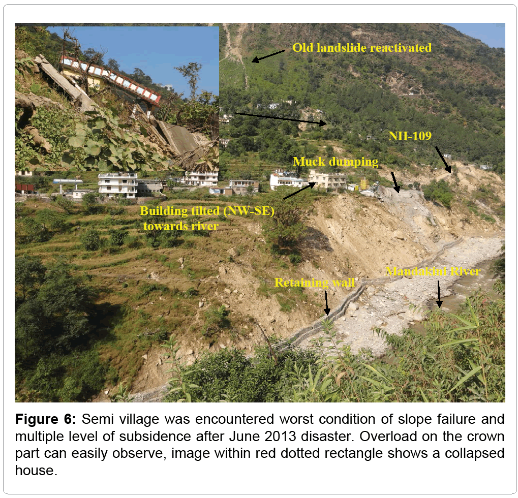
Figure 6: Semi village was encountered worst condition of slope failure and multiple level of subsidence after June 2013 disaster. Overload on the crown part can easily observe, image within red dotted rectangle shows a collapsed house.
Bank erosion: It is well-known that riverbank retreat occurs both by continuous fluvial erosion as well as abrupt bank failure [16,17]. River bank-toe erosion causes to increase the bank height and the slope of the bank to the extent that eventually riverbank mass failure occurs [18]. Bank erosion by streams and rivers is the major causative factor for the slope failure in this area. Old landslide debris, Quaternary deposits, colluvium, alluvium and overburden material at several locations makes the area vulnerable for the bank erosion. At a number of places in the field, bank erosion is observed to cause slope instability e.g., Pandukeswer, Gobindghat, Narayan bagar, Ganganagar, Vijaynagar, Chandrapuri, Tilwara etc. villages are under threat of landslides (Figures 7A-7F). Besides, lake formation was observed near Jaggi-Bedula slide, right bank of Madhyamaheswer river (Figure 7D) and the chronic kaliysaur landslide, left bank of Alaknanda river also triggered by bank/toe erosion.

Figure 7: (A) Indiscriminate construction right bank of Nandakini river at Ghat town (B) NH-109 going on eroded terrace at Vijaynagar town, Mandakini river shifted left bank (10-15 m.) (C) Landslide along Karanprayag-Tharali road, generated by change in angle of repose (D) Lake formation observed near Jaggi-Bedula slide right bank of Madhyamaheswer river. (E) A major bouldery debris slide triggered by MCT at Thalla bend along Pokhri - Mohankhal road, approx. 200 m road stretch remarkably subsided. (F) View of severally damaged Barrage of Singoli - Bhatwari hydroelectric project at Kund after June 2013.
Seismicity: The entire Himalayan region is geo-dynamically active and prone to earthquake along the existing thrust and faults. The epicentre of Chamoli earthquake (1999) is very close to Munsiari Thrust (MCT zone) across the Alaknanda River at Helong. The area falls under the high hazard and very high hazard categories (seismic zone IV and V) of the seismic zonation map of India. Moreover, habitations and infrastructure which are close vicinity to MCT zones are also susceptible to landslides (Figure 7E). Keefer [19] in a comprehensive study has identified 14 types of landslides associated with earthquake activity. The most common are rock falls, rock slides and disrupted soil slides. Earthquakes reduce stability by imparting both a shearing stress and a reduction in resistance to slope material. Uttarkashi (1991) and Chamoli earthquake (1999) and frequently occurring tremors of short duration have widened the joints of already highly fractured and jointed rocks of the area. Being tectonically active zone, the area is controlled by structural elements like thrust/faults and lineaments (Figure 3), subsequently responsible for slope failure during earthquake. Seismicity creates disturbance in these tectonic features and eventually causes landslide within their vicinity.
Deforestation: Deforestation has been a significant effect on soil erosion and run-off in the Himalaya due to moderate and steep slope. Large scale depletion of forests has drastically altered the hydrological conditions of the slopes. Infrastructure development and growing population in the study area is putting tremendous pressure on the agriculture land and forest land leading to deforestation. A large number of trees felling have been happened in the area for the road construction. Trees were uprooted either by dumping of excavated debris on the valley side or by landsliding occurring after the excavation. The vegetation covering the hill slopes also gets eroded in the process, which leads to further soil erosion as well as increase in run-off from the hill slopes [13].
Developmental activities like unscientific way of construction of houses, canals and unscientific blasts during road construction increase the probability of landslides [20]. The women led ‘Chipko’ movement (1973) started after the Alaknanda flood (1970), caused by logging in the Alaknanda valley, they connected the deforestation to landslide and flooding. Recent scientific studies suggest that landslide, flood and deforestation in the Alaknanda valley are closely related [21,22]. Apart from this forest fires have been increased in recent years, which lead to increased surface erosion and mass wasting.
Forest lands have been cleaned in a large scale for the construction and mining. The state governments own data shows that 1,608 hectares on the riverbeds were being mined in 2012. The state’s forest department says that between 2000 and 2010, almost 4,000 hectares of land previously under its jurisdiction were diverted for mining [23]. As per data from the Union Ministry of Environment and Forests (MoEF), 44,868 ha of forest land have been diverted to non-forest use in Uttarakhand since 1980 [24]. The maximum number of development projects that required forest diversion has been approved in Chamoli district. A total of 1,767 ha forest land has been cleared in the district. Interestingly, the maximum forest area that has been cleared for hydel projects, roads and transmission lines is in Chamoli, Uttarkashi, Rudraprayag and Pithoragarh [25-28]. While Chamoli and Rudraprayag district are integral part of upper Alaknanda valley.
Heavy and prolonged rainfall was the main triggering factor for landslides in Upper Alaknanda valley. The area is observed to be highly tectonised and the same has rendered the rocks of the area highly sheared, fractured and jointed. As many as three sets of joints are observed at most places. Field work carried out in the area suggests that landslides have been largely (in 77 percent cases) caused either by slope modification for infrastructure development or by toe/bank erosion by streams and rivers, mostly during spells of high discharge. Besides, zones of old landslides material, colluviums and alluvium deposits are identified as being most vulnerable to slope failure. Together with these the slopes occupied by unconsolidated material, loose soil and highly weathered and fractured rocks are observed to be vulnerable. Structural disposition of rocks is also observed to facilitate mass movement. The decision to settle down over stable and firm ground at the same time minimized losses during an earthquake.
Indiscriminate and unscientific way of construction is most important anthropogenic activities accelerated deforestation and landslide incidences. Deforestation is the main contributing factor for the slope instability processes. The transportation network is the life line for the socio-economic development of hills and the hydropower potential provides the means to finance economic growth and social development. It is therefore necessary that any type of construction must be done according to the properly considered geo-environmental and ecological factors. Geo-environmental factors include geology/ structure, slope, relative relief, landuse/landcover and hydrology; these are controlling factors for the landslides. It should be understood that infrastructure development if properly done it will be beneficial and auspicious for the human being but if not it will take toll in the form of disaster.
Landslide and flash flood are both induced by atmospheric precipitation and can well be predicted in case real time data on rainfall is available and thresholds are worked out for different catchments based upon slope, geology, distribution of Quaternary deposits, catchment area and landuse. Generation of timely warning, its timely dissemination in the area likely to be affected and prompt and effective response hold the key to saving lives. Metrological observation network in the area however needs to strengthen for the generation of site specific warnings.
In case of road construction, distance from the river and streams is also important. Mostly road disruption on large scale takes place at such location where toe/bank erosion occur frequently. We have to understand that farther the road from the river, safer it is. It may cost a little more in the beginning but it would prove out to be a better decision in long run. Road construction in the hills is necessarily accompanied by slope stabilisation and rainwater disposal measures. Durability of road network will be useful and strengthened response/relief, recovery, search and rescue operation after disaster. Besides, considering 68% debris slide in the study area, afforestation of the surroundings using site specific species, wire mesh and jute netting along with appropriate engineering measures can help in the stability of slope. Landslide hazard can be minimized by avoiding construction in landslide prone region. Moreover, in this area infrastructure development project should be allowed only after proper understanding of geological, geotechnical and environmental factors.
Landslide inventory map are useful for the planning of infrastructure development. Such maps also give ground level information about the sites and helpful in clear demarcation of safe and unsafe zones. Identification of such sites is very useful for the prohibition and regulation of future construction and developmental activities where cloud burst frequently occurred and active and old landslide zones situated. For better landslide risk reduction mass awareness on large scale should be conducted.