
Indexed In
- Euro Pub
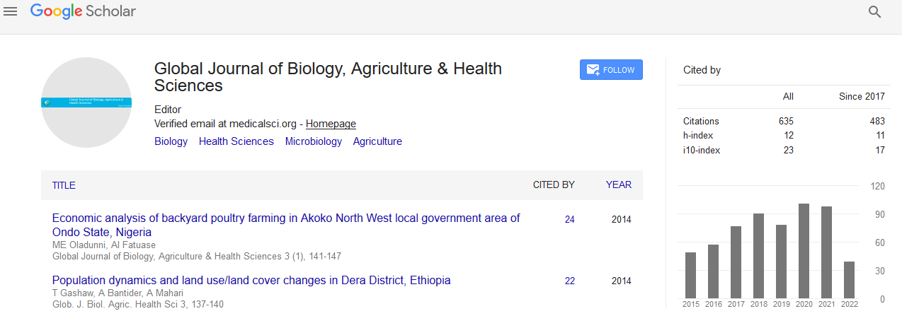
- Google Scholar
Useful Links
Share This Page
Journal Flyer
Open Access Journals
- Agri and Aquaculture
- Biochemistry
- Bioinformatics & Systems Biology
- Business & Management
- Chemistry
- Clinical Sciences
- Engineering
- Food & Nutrition
- General Science
- Genetics & Molecular Biology
- Immunology & Microbiology
- Medical Sciences
- Neuroscience & Psychology
- Nursing & Health Care
- Pharmaceutical Sciences
Abstract
Appraisal of Some Water Quality Criteria of the Shatt Al-Arab River by Applying Geographical Information System (GIS)
Abdul-Razak M. Mohamed, Sadek A. Hussein, Laith F. Lazem
The present work illustrates the potential application of geographic information systems (GIS) and spatial analysis techniques to classify spatial and temporal distribution and predictions of some water characteristic. The study extended from December 2011 to November 2012. To execute the work three stations were selected based on the nature of the areas. Water samples were collected on monthly basis, from the three stations. Results revealed that water temperature ranged between 11.3-35.7 ˚C, salinity varied from 1.37 to 3.13 ‰, the pH ranged from 7.33 to 8.33. TDS differed from 1985 to 7131 mg/L, the dissolved oxygen 6.1-9.5 mg/L. Transparency fluctuated from 38.3 to 72.3 cm
Published Date: 2016-10-05;